

Utah has five national parks, the famous Mighty Five, and they’re all packed into the southern third of the state within a single week’s road trip of each other. We’ve filmed in all of them, repeatedly, and here’s the short version. Zion is the best. Bryce Canyon has the best sunrise. Arches has the most famous rocks. Canyonlands has the most solitude. Capitol Reef is the one everybody skips and shouldn’t.
This guide ranks all five honestly, gives you the 2026 fee and permit picture, covers the monuments most folks miss, and lays out the route that connects everything. The per-park detail lives in our dedicated guides, linked throughout.
The big 2026 news first. Arches dropped its timed entry reservation requirement this year, so for the first time since 2022 you can show up to every Utah park without an entry reservation. Zion raised camping and wilderness permit fees instead, which we break down in our Zion 2026 fee and permit guide.

The Mighty 5 Compared
| Park | The Draw | Time Needed | Base Town | 2026 Fee |
|---|---|---|---|---|
| Zion | Angels Landing, The Narrows, 2,000 ft canyon walls | 2 to 3 days | Springdale | $35 |
| Bryce Canyon | The largest collection of hoodoos on Earth | 1 to 2 days | Bryce Canyon City | $35 |
| Arches | Delicate Arch and 2,000+ stone arches | 1 to 2 days | Moab | $30 |
| Canyonlands | Mesa Arch, canyon country at continental scale | 1 to 2 days | Moab | $30 |
| Capitol Reef | The Waterpocket Fold, orchards, no crowds | 1 to 2 days | Torrey | $20 |
All five fees are per vehicle and good for seven days. If you’re doing the full loop, the $80 America the Beautiful annual pass beats paying $150 in individual fees. Nonresidents of the US should note that Zion and Bryce Canyon now charge an additional $100 per person, so the $250 nonresident annual pass is the move for international road trippers.
117 public lands destinations are under threat. Get the free briefing that 27,000+ people use to stay informed and take action.

1. Zion National Park
The best park in Utah, and it’s not close. Zion Canyon is half a mile deep, the hikes are the most dramatic in the park system, and the Virgin River pulls off the neat trick of being both the architect of the place and its best trail. Yes, nearly five million folks a year agree with us. It’s popular because it’s extraordinary.
Angels Landing requires a $6 per person lottery permit through Recreation.gov, with seasonal and day-before drawings. The Narrows needs no permit bottom-up, just a tolerance for hiking in a river. The free shuttle is mandatory in Zion Canyon roughly March through November, and the Zion-Mount Carmel Highway is the best scenic drive in the state.
The crowd fix is built into the park. Kolob Canyons, Zion’s quiet northwest corner off I-15, gets a fraction of the canyon’s traffic and looks like a private national park. We wrote it up separately, along with Lava Point, the park’s high overlook on Kolob Terrace Road.
For 2026, campground rates rise on July 1, Watchman electric sites go to $45 a night, and all wilderness permits moved to Recreation.gov in January. Full details in our fee and permit breakdown. Start planning with the Zion hub, things to do, best hikes, and the best time to visit.


2. Bryce Canyon National Park
The best sunrise in the national park system. Bryce isn’t actually a canyon. It’s a series of natural amphitheaters cut into the edge of a high plateau, filled with the largest concentration of hoodoos on Earth. At first light from Sunrise or Inspiration Point, the whole basin glows orange like it’s lit from inside.
The essential move is getting below the rim. The Navajo Loop through Wall Street, combined with the Queens Garden trail, is about three miles and the single best short hike in Utah. Up top, the rim sits between 8,000 and 9,100 feet, so summer stays cool and winter buries the hoodoos in snow, which is the park’s most underrated look.
A day covers the highlights and two days covers the park. We settled the obvious question in Zion vs Bryce Canyon. More in the Bryce Canyon hub, things to do, and facts.


3. Arches National Park
The most famous rocks in America. More than 2,000 documented natural arches in one compact park, including Delicate Arch, the one on the license plate. The three-mile round trip hike to it at sunset is a Utah rite of passage, and the slickrock approach with no shade is harder than the distance suggests.
For 2026 the park lifted its timed entry requirement, so no reservation is needed. The trade-off is lines at the gate on spring and fall weekends, so arrive before 8 am or after 3 pm. Landscape Arch, a 306-foot ribbon of rock that looks ready to drop any minute, anchors the Devils Garden trail. The Fiery Furnace requires a $10 per person permit or a ranger-led tour and rewards you with the best maze in the park.
Arches ranks third because it’s a half-day park wearing a full-day crowd. See it well and pair it with Canyonlands, 40 minutes away. Plan with the Arches hub, things to do, best hikes, and facts.


4. Canyonlands National Park
The Grand Canyon with a tenth of the people. Canyonlands is Utah’s largest national park, carved into four districts by the Green and Colorado Rivers, and most folks only ever see one of them. Island in the Sky is the drive-up mesa with Mesa Arch at sunrise, the Green River Overlook, and the Shafer Canyon switchbacks dropping a thousand feet off the rim.
The Needles district, 90 minutes south, is the best backpacking in Utah. The Maze is one of the most remote places in the lower 48 and should be treated accordingly. The 100-mile White Rim Road is the classic multi-day 4WD and bikepacking loop, permit required.
It ranks fourth only because its scale works against casual visits. Given three full days, it would fight Zion for the top spot. See the Canyonlands hub, things to do, best hikes, and facts.


5. Capitol Reef National Park
The most underrated park in Utah. Capitol Reef protects the Waterpocket Fold, a hundred-mile wrinkle in the Earth’s crust, and it sits dead center on the Mighty Five route while somehow staying the least visited of the five. Ranking it last says more about Utah than about Capitol Reef.
The historic Fruita orchards sit right in the canyon bottom, and in season you can pick fruit the pioneers planted the ancestors of. The Gifford House sells pies until they run out, which is early. Hickman Bridge is the easy essential hike, Grand Wash is the easy essential canyon, and Cassidy Arch gets you above it all in two miles.
The $20 fee applies to the Scenic Drive, and the Cathedral Valley loop is the best high-clearance day in Utah, monoliths rising out of empty desert with nobody around. See the Capitol Reef hub, things to do, and facts.

Beyond the Mighty 5, Utah’s National Monuments
Utah’s monuments would be the headline attraction in most states. Here are the ones worth working into a trip, roughly in order. We ranked the whole country’s in our guide to every US national monument.

Grand Staircase-Escalante National Monument
Nearly 1.9 million acres of slot canyons, waterfalls, and petrified wood between Bryce and Capitol Reef, crossed by Scenic Byway 12, the best road in Utah. Lower Calf Creek Falls and the Dry Fork slots (Peek-a-Boo and Spooky) are the classic outings. You drive through it on the Mighty Five loop anyway. Budget a day for it.

Bears Ears National Monument
Sacred land to five tribes and home to more than 100,000 archaeological sites, including the cliff dwellings of Cedar Mesa and the House on Fire ruin. Its boundaries have been redrawn by three administrations and remain a live political fight, so check current access rules before you go. Treat every site like the irreplaceable cultural record it is.
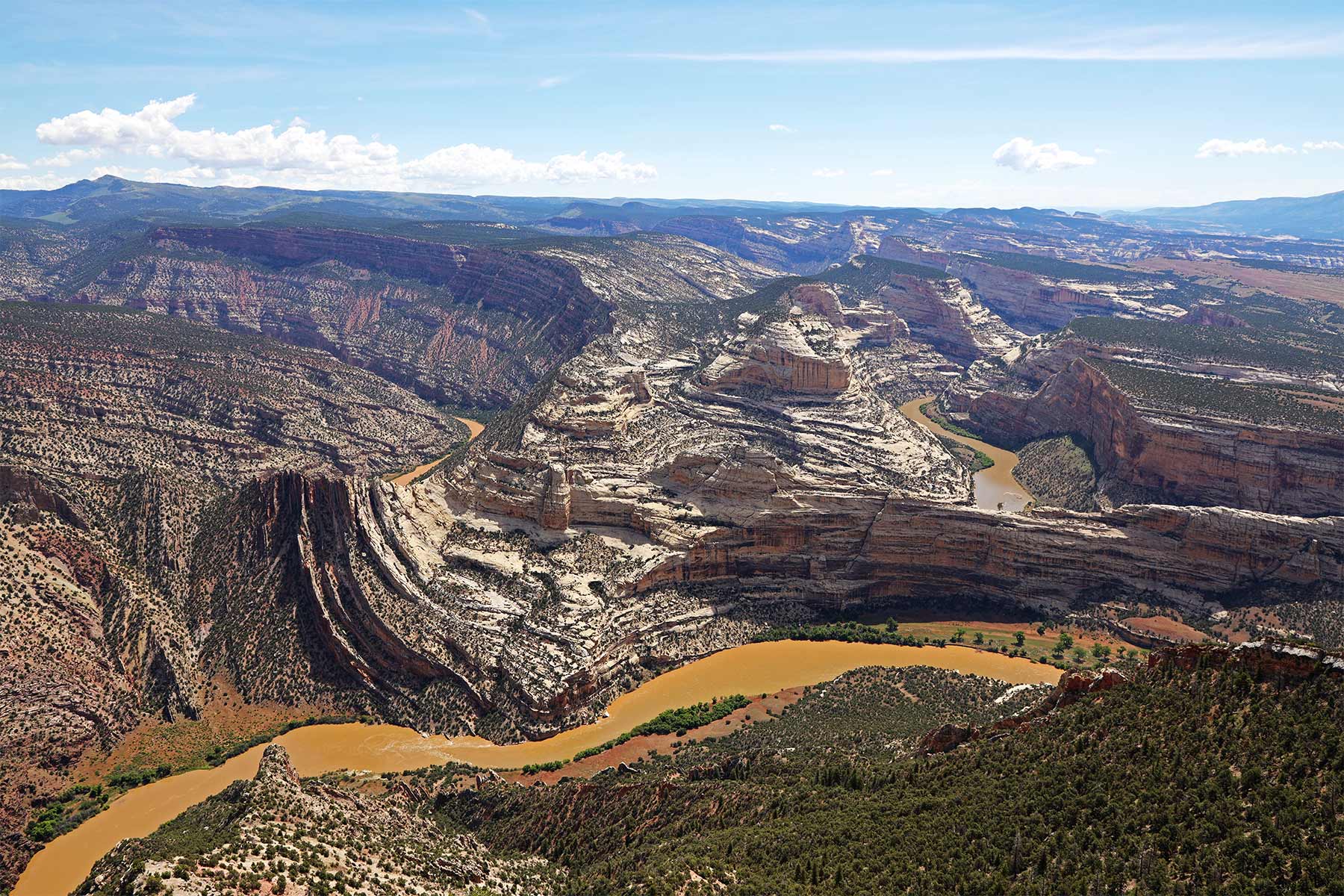
Dinosaur National Monument
The Quarry Exhibit Hall near Jensen encloses a wall of about 1,500 dinosaur bones still embedded in the rock, and you can touch 149-million-year-old fossils with your actual hands. The monument spills into Colorado and adds world-class rafting on the Green and Yampa. It’s a four-hour detour from the Mighty Five loop and worth it for anyone traveling with kids.
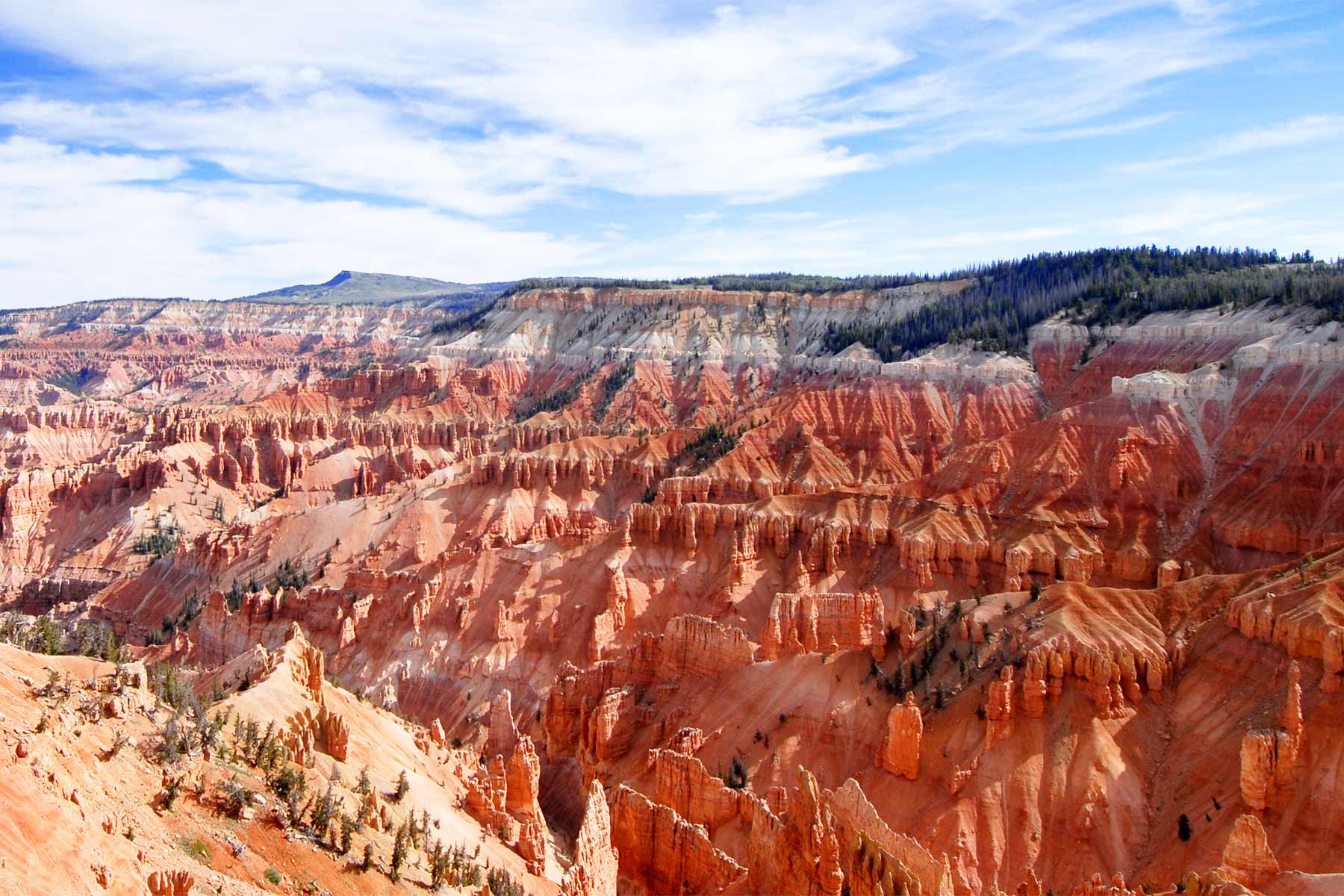
Cedar Breaks National Monument
Bryce Canyon’s quieter sibling, a hoodoo-filled amphitheater half a mile deep with a rim above 10,000 feet. Summer brings one of the best wildflower displays in the state and some of the darkest night skies anywhere. It’s 30 minutes from Cedar City and an easy add between Bryce and Zion. The rim road closes under snow much of the year.

Natural Bridges National Monument
Three massive stone bridges, carved by water rather than wind, in a quiet corner of southeast Utah. It was the world’s first International Dark Sky Park, and Owachomo Bridge under the Milky Way is the photograph to chase. Our full guide covers the loop drive and hikes.
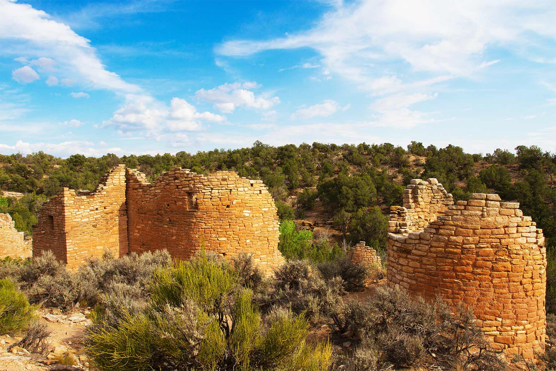
Hovenweep National Monument
Eight-hundred-year-old ancestral Puebloan towers standing on the rim of a quiet canyon on the Utah-Colorado line. The two-mile rim loop past the towers takes an hour and you may have it to yourself. Pairs naturally with Bears Ears country.

Also Worth Knowing
Timpanogos Cave hides a tour-only cave of helictites at the top of a steep paved trail in American Fork Canyon, 40 minutes from Salt Lake City and a good leg stretch on arrival or departure day. Rainbow Bridge, one of the largest natural bridges on Earth, requires a boat ride across Lake Powell or a long permitted hike across Navajo Nation land. Jurassic National Monument at the Cleveland-Lloyd quarry holds the densest concentration of Jurassic dinosaur bones ever found, deep in the San Rafael Swell.
Planning a Utah National Parks Road Trip
When to Go
April, May, September, and October are the answer. Summer pushes Arches and Canyonlands past 100 degrees and fills Zion’s shuttle line, though Bryce and Cedar Breaks stay pleasant at elevation. Winter is the sleeper season. Bryce under snow is spectacular, Zion is quiet, and you’ll trade some closed high-country roads for empty trails. The Narrows is best in early fall when the water is low and warm-ish.
The Route
The classic loop runs Salt Lake City to Moab for Arches and Canyonlands, west on I-70 and south to Capitol Reef, down Scenic Byway 12 through Grand Staircase-Escalante to Bryce, then US-89 to Zion and out through Las Vegas or back up I-15. Eight days does it comfortably. Five days is possible if you treat Capitol Reef and Canyonlands as half days, which we’ve already argued you shouldn’t.
| Days | Base | What You’re Doing |
|---|---|---|
| 1 to 2 | Moab | Arches (Delicate Arch at sunset, Devils Garden early) |
| 3 | Moab | Canyonlands Island in the Sky (Mesa Arch at sunrise) |
| 4 | Torrey | Capitol Reef (Hickman Bridge, Scenic Drive, pie) |
| 5 | Bryce / Tropic | Scenic Byway 12 through Escalante, Bryce at sunset |
| 6 | Bryce / Tropic | Sunrise on the rim, Navajo Loop and Queens Garden |
| 7 to 8 | Springdale | Zion (Angels Landing if you drew a permit, The Narrows) |
Drive times are honest out here. Salt Lake City to Moab is about 3.5 hours, Moab to Capitol Reef about 2, Capitol Reef to Bryce about 2.5 on Byway 12, and Bryce to Zion under 2. We mapped five variations, including a Vegas loop, in our Utah national parks road trip guide.
Which Park Do You Skip With 3 or 4 Days?
Capitol Reef. It stings to type after defending it for five paragraphs, but our own ranking puts it fifth and the geography backs it up. With three days, do Zion, Bryce, and Arches. With four, add Canyonlands, which sits 40 minutes from Arches and shares your Moab hotel room, so it costs almost nothing to include. Capitol Reef sits alone in the middle of the route, demands the most driving for the fewest hours, and rejoins your life the easiest, since it anchors a perfect second trip down Scenic Byway 12 with Grand Staircase-Escalante. The park you skip is never Zion.
Permits and Reservations Checklist for 2026
- No entry reservations anywhere. Arches lifted its timed entry requirement for 2026.
- Angels Landing. $6 per person lottery on Recreation.gov, seasonal or day-before.
- Fiery Furnace. $10 per person permit or ranger tour, Arches.
- Zion wilderness. All permits on Recreation.gov as of January 2026, day-use $6, overnight $20 plus $7 per person per night. Covers The Subway and top-down Narrows.
- Campgrounds. Book six months out for spring and fall. Zion’s rates rise July 1, 2026.
- White Rim Road. Day and overnight permits through Canyonlands.
One more note. Utah also has five national forests, and Fishlake’s Pando aspen clone, a single organism spread across more than 100 acres, is the kind of roadside wonder this state hands out for free. We wrote about it here.
Why Listen to Us About Utah’s Parks
We’ve spent years filming Utah’s parks and public lands through every season, and we’ve worked with the National Park Service, the Department of the Interior, and the U.S. Forest Service. The ranking is ours, built on repeat visits rather than a single drive-through, and we’re happy to defend Capitol Reef’s honor in the comments.
See how the Mighty Five stack up against all 63 national parks ranked. The order shifts there, with Canyonlands and Capitol Reef jumping ahead of Arches and Bryce, because that list scores each park head to head on the national stage, while this one ranks them as pieces of a single Utah trip, where Bryce’s sunrise and Delicate Arch earn their keep in a day.
Utah National Parks Map (Printable)
Download the printable Utah National Parks Map.


