
Article Overview: Best Hikes in Canyonlands National Park
The best hikes in Canyonlands National Park are some of the best hikes in the country. This roughly 340,000-acre southeastern Utah park combines some of the most rugged backcountry in the country with Colorado Plateau scenery..
Undoubtedly, Canyonlands National Park proudly sits among Utah’s Mighty 5 parks. It’s the largest park in the group but also has the lowest annual visitors. Compared to Zion National Park, Canyonlands is more than twice as large, but Zion gets 600% more visitors each year.
It begs the question–why are the best hikes in Canyonlands National Park not attracting more crowds? In The Mighty 5, Canyonland is the beast of the group.
It’s larger than Los Angeles or Phoenix. Trying to see the park in one day is almost impossible, given that it’s spread into three different land sections. The Green and Colorado Rivers split the park sections, offering a fourth region for river activities. Then the fifth section is in a canyon even more remote than the others.
At the same time, seeing all of the sections would require 408 miles of drive time. Much like the North Rim and South Rim of the Grand Canyon, there’s not an easy route between them.
Furthermore, Canyonlands is also one of the more remote parks, sharing this chunk of Utah with Arches National Park. You must WANT to be here and have to pass up some pretty amazing parks along the way.
There’s also an unforgiving aspect of Canyonlands National Park, which is why it attracts more experienced and adventurers.
It’s challenging to whittle down dozens of trail options into one EPIC list of best hikes in Canyonlands National Park, but let’s give it a shot.

12 Best Hikes in Canyonlands National Park
Table Of Contents: Best Hikes in Canyonlands National Park
Table of Contents: Best Hikes in Canyonlands National Park

Things to Know Before You Visit Canyonlands National Park
Entrance Fees
$30 vehicle OR if you plan to visit more National Parks within the next 12 months, purchase the America the Beautiful Pass. It can be found online or at the entrance gates to most national parks. This pass gets you into all National Parks, Forests, Monuments, and more, including 2,000 sites for free after a one-time $80 fee.
Sunscreen
Use it. Lots of it. Especially this one, which I never leave the house without because it plays nice with our dear friend, Earth 🙂
Insect Repellent
If you’re looking for a good insect repellent that plays nice with our good friend Earth, we recommend this one. Try this one if you’re a DEET person.
Guide Book
The Best Guide Book for Canyonlands National Park is this one which we’ve marked up and highlighted quite a bit.
Map
The Best Map: I like this map best for Canyonlands National Park.
National Parks Checklist Map: This beautiful National Parks Checklist Map can be ordered to your house.
Framed National Parks Map: We’re a sucker for maps; this framed national parks map is the best.
Where to Stay in Canyonlands National Park
Where to Stay: This is our favorite hotel in/around Canyonlands National Park.

The Layout of Canyonlands National Park
Planning the best hikes in Canyonlands National Park means you need to know which district it’s in. Since no roads cross the rivers, accessing Islands in the Sky and The Maze means driving 170 miles.
Here are the four regions or districts of Canyonlands National Park:
- Island in the Sky: Referred to as the “Sky District,” and is located in the northern part of the park. The Island in the Sky district offers stunning panoramic views of deep canyons carved by the Colorado River. It’s known for its mesa top drives and overlooks, making it a popular destination for those seeking breathtaking vistas.
- The Needles: Situated in the southeastern park, The Needles offers by colorful rock formations, towering spires, and intricate canyons.
- The Maze: The Maze is the most remote and rugged district, located in the western part of the park. You must have a 4WD high-clearance vehicle to get here.
- The Rivers (Colorado and Green Rivers): This district includes the canyons carved by the Colorado and Green Rivers. That means opportunities for river rafting and kayaking adventures.
- Horseshoe Canyon: Horseshoe Canyon is located in the western part of Canyonlands National Park. It is famous for its impressive collection of ancient rock art and well-preserved petroglyphs.
Top 12 Best Hikes in Canyonlands National Park
#12 Gooseberry Trail
- Distance: 4.6 miles
- Difficulty: Strenuous
- Elevation Gain: 1,529 feet
- Time Required: 4 – 6 hours
- Section: Island in the Sky
This is the steepest hike in Canyonlands National Park’s Island in the Sky District—likely the steepest maintained trail in the park. It drops down from the top of the Island in the Sky mesa and switchbacks severely down to the White Rim Road, which follows the evocative White Rim Bench that girdles the mesa about midway down to river level.
Undoubtedly watch your footing on this one, given the sheer grade and loose scree here in the uppermost portions of Gooseberry Canyon. The scenery is knockout, though, and you’ll also likely enjoy plenty of solitude on this comparatively little-trammeled trail. There’s a backcountry camp near the lower trailhead, freeing you up for further explorations along the White Rim Bench/Road (including to some amazing brink-edge looks into Monument Basin).

#11 Slickrock Foot Trail
- Distance: 2.4 miles
- Difficulty: Easy
- Elevation Gain: 80 feet
- Time Required: 2 – 3 hours
- Section: Needles
Basically, the Slickrock Foot Trail provides one of the best introductory hikes in Canyonlands National Park’s Needles section. At the same time, many trails in this district dive down into the joints, canyons, and rock gardens, but this easy lollipop loop sticks to slickrock uplands.
Accessed along the Needles scenic drive, the Slickrock Trail comes marked by cairns. Four viewpoints lie along its route. The first—situated just before the trail splits into a loop—gives you fine far-reaching panoramic looks, specifically with landmarks including the Needles, Elaterite Butte, the great lightning rod of North Sixshooter Peak, the La Sal and Abajo Mountains.
Additionally, other viewpoints allow you to peer into the edging defiles of Little Spring and Big Spring canyons and north-northwest to the stair-stepped Island in the Sky rise up to Junction Butte and Grand View Point.

#10 Whale Rock
- Distance: 0.8 miles
- Difficulty: Moderate
- Elevation Gain: 141 feet
- Time Required: 1 – 1.5 hours
- Section: Island in the Sky
Among the beloved hikes in Canyonlands National Park for kids—and rewarding for anyone seeking a wide-open vantage—Whale Rock looms as a bulbous sandstone fin on the Island of the Sky near Upheaval Dome. From the trailhead, you can indeed make out the formation’s rough resemblance to a whale—and anticipate the fun of climbing up the “tail” to the “blowhole” up top.
After a short walk across desert scrub, you’ll begin the ascent, which is a semi-steep but overall easy slickrock clamber. Contrarily, potholes stud the broad finback of the rock. After that, the views unfurl in all directions across the Island in the Sky and beyond across dissected canyons and spires.
Additionally, Whale Rock provides an excellent big-picture, side-on view of Upheaval Dome, especially satisfying if you’re also going to hike to its overlooks (more on that to come!).

#9 White Rim Overlook Trail
- Distance: 1.8 miles
- Difficulty: Easy
- Elevation Gain: 159 feet
- Time Required: 1 – 2 hours
- Section: Island in the Sky
The White Rim Overlook Trail is a simple scenic route to the edge of the Island in the Sky mesa–another of the best hikes in Canyonland National Park, undoubtedly. It shares a trailhead with the Gooseberry Trail, but unlike that demanding, switchbacking adventure, this is a gentle, easy-peasy sort of stroll that stays up top.
Moreover, the White Rim Overlook Trail tends to be less busy than the similar Grand View Point Trail, and the Park Service also recommends it for those acrophobic types who might find the latter’s exposure a bit unsettling. It follows a well-marked route along a southeasterly spur of the Island in the Sky.
Another key point is that the White Rim Overlook looks east over the tremendous breaks dropping far down to the Colorado, with the namesake White Rim bench of chalk-colored sandstone situated centerstage.
You also get a nice top-down look into Monument Basin, a natural sculpture garden of spires and buttes bearing not a little resemblance to Monument Valley. In addition, a view east to the La Sal Mountains, which loom past 12,000 feet.

#8 Upheaval Dome Overlooks
- Distance: 1.2 miles to the farthest overlook
- Difficulty: Moderate
- Elevation Gain: 115 feet
- Time Required: 90 minutes maximum
- Section: Island in the Sky
Basically, hiking in Canyonlands National Park shows off an absolute smorgasbord of geology, of course, but the mighty swell of Upheaval Dome ranks up there in terms of sheer enigmatic oddness. Situated on the Island of the Sky mesa, it resembles, to an aerial observer, a huge stone bull’s-eye.
The Upheaval Dome Overlooks give you the best on-the-ground appreciation for this strange, gaping monstrosity. There are two overlooks, and it’s well worth taking both in on the short but steep trail.
Need more of a challenge?: Circle the canyons around Upheaval Dome on the Syncline Trail. Park rangers say it’s not only the hardest hike in the Sky district but also the place where the most hiker rescues happen. Obviously, this is for the experienced hikers only.
As a matter of fact, geologists have long debated how Upheaval Dome formed, with two leading theories. On one hand, it is suggested to be a salt dome formed from deposits of viscous liquids that pushed through the bedrock of an ancient sea. Differential weathering and erosion then carved the bulged, tilted sedimentary stacks as a result to create the rimmed spiral.
On the other hand, a theory suggests Upheaval Dome is the remnants of a bulged impact crater formed by the momentous smack of a 60-million-year-old meteorite.

#7 Aztec Butte
- Distance: 1.4 miles
- Difficulty: Moderate
- Elevation Gain: 222 feet
- Time Required: 1.5 hours
- Section: Island of the Sky
Set on the Island of the Sky mesa above the uppermost breaks of Trail Canyon, the slickrock knob of Aztec Butte serves up swoon-worthy views into the Colorado Plateau prehistory. It’s that combo that makes this one of the best hikes in Canyonlands National Park.
From the road, this short trail follows a sandy wash to a fork. The eastern, righthand path leads up Aztec Butte, partly marked by cairns and with a little scrambling involved to attain the summit. The views from here extend from the broad mesa top-down Trail Canyon and out to the distant, laccolithic heights of the Abajo and La Sal mountains even more. As a result, you might spend more time on this trail just gawking.
In addition, you’ll see a few signs of Ancestral Puebloan ruins along the flanks of Aztec Butte, and more await on this hike. On the final stretch, you’ll see enigmatic archaeological sites used by ancient civilizations. View from a distance; don’t enter or otherwise touch them.


#6 Druid Arch
- Distance: 10.8 miles
- Difficulty: Strenuous
- Elevation Gain: 503 feet
- Time Required: 5 – 7 hours
- Section: Needles
Druid Arch is one of the best hikes in Canyonlands National Park because, at least to me, it looks like Zion and Arches National Parks had a baby–a really tough, challenging baby–and this trail is the cradle.
Nestled at the head of Elephant Canyon in the Needles District backcountry, this is one of the most strenuous yet rewarding views you’ll find in Needles by and large.
To illustrate, it’s a very distinctive-looking arch: blocky and pillared, with two sliver-shaped keyholes. The overall visual effect particularly calls to mind Stonehenge or another of the other ancient human-made standing-stone structures in the English countryside—hence the whole “Druid” tag.
The trail to Druid Arch kicks off at Elephant Hill and initially traces the route to Chesler Park. However, it then splits off all of a sudden and heads up along the sandy wash of Elephant Canyon. Finally, the last quarter-mile to reach the arch is the toughest part: a scrambling climb involving a ladder.


#5 The Chocolate Drops
- Distance: 8.8 miles
- Difficulty: Moderate
- Elevation Gain: 540 feet
- Time Required: 3.5 – 5 hours
- Section: The Maze District
The Maze District is the most remote unit in Canyonlands National Park: a grand corrugated outback that represents the Southern Utah wildlands at its best. That’s one of many reasons it has many of the best hikes in Canyonlands National Park for advanced hikers.
Straightaway, it’s as undeveloped as national parkland comes, though it’s hard to see exactly how you could install much in the way of “improvements.” The Chocolate Drops Trail provides a comparatively easy introduction to the far-flung beauty of the Maze. At the same time, it shows off one of the district’s defining landmarks.
Those would be the Chocolate Drops: a quartet of soaring, blocky-but-skinny brown fins of Organ Rock Shale topped with pale caps. Situated due southwest of Petes Mesa, north of the Land of Standing Rocks, they stagger the skyline at the north end of a long slickrock divide between South Fork Horse Canyon and the Pictograph Fork and are unmistakable from the Maze Overlook.
REMINDER: You need a 4WD high-clearance vehicle to access this section of the park, not to mention the skills to fix a flat tire or be prepared with desert survival skills.
But the cairn-lined route is mostly level and undemanding by comparatively tough Maze standards. You’ll see plenty of other standing rocks besides those magnificent Drops, and also nab a very far-off view of the Harvest Scene Pictograph Panel, enigmatic Barrier Canyon-style rock art in the Pictograph Fork Canyon.

#4 Salt Creek Canyon Trail
- Distance: 22.5 miles
- Difficulty: Moderate
- Elevation Gain: 80 feet
- Time Required: 10+ hours
- Section: Needles
Best tackled as an experienced backpacking overnighter, the Salt Creek Canyon Trail in the Needles District offers one of the best hikes in Canyonlands National Park for archaeology buffs. Also, it emphatically delivers some epic scenery courtesy of dramatic sandstone formations.
Kicking off at the Cathedral Butte Trailhead on Salt Creek Mesa, the trail drops into the East Fork Salt Creek Canyon and follows this—circumventing riparian thickets and reeds—into the mainstem Salt Creek Canyon. To that end, sights along the way include a remarkable lineup of cliff-dwelling ruins and indigenous rock art, including the famous, colorful All-American Man Pictograph and the Four Faces.
In addition, this canyon-belly route has numerous sandstone arches, including the strikingly circular Wedding Ring Arch.

#3 Mesa Arch
- Distance: 0.6 miles
- Difficulty: Easy
- Elevation Gain: 56 feet
- Time Required: Half-hour
- Section: Island of the Sky
One of the truly classic best hikes in Canyonlands National Park—and among the undeniably iconic vistas in Utah—Mesa Arch offers whopping scenery for minimal effort. This 29-foot clifftop arch overlooks the yawning, intricately sculpted depths of Buck Canyon that splits the White Rim on its way down to the Colorado River.
First, it’s a short walk off Island in the Sky Road to reach Mesa Arch. Second, the ease of access combined with the stupendous natural tableau makes this a super-popular trail, especially among shutterbugs looking to nab a ravishing sunrise shot. It’s a joy to peer through the opening and see framed within such striking landmarks as Washer Woman Arch, Monster Tower, Airport Tower, and—on the eastern skyline—the La Sal Mountains.
Mesa Arch makes an excellent hike for youngsters, but definitely keep them close in the vicinity of the arch, which stands over a 500-foot cliff face.

#2 Chesler Park/Joint Trail Loop
- Distance: 10.7 miles
- Difficulty: Strenuous
- Elevation Gain: 1,188 feet
- Time Required: 5-7 hours
- Section: Needles
This ranks among the geologically dazzling best hikes in Canyonlands National Park. There are multiple ways to hike the lovely, almost dreamlike Chesler Park area, including substantially shorter out-and-backs and loops, but this long walkabout gives you just about the best tour possible as you venture through the base of the needles formations.
Chesler Park is a broad grassland basin edged by remarkable sandstone spires and pinnacles, part of the Cedar Mesa Sandstone formation. Starting from the Elephant Hill Trailhead, the trail to Chesler Park leads through pinyon-juniper scrub, traverses the depths of Elephant Canyon, and serves up views westward toward the staggered drop-down country of the Grabens as well as the toothy Needles.
What’s more is that after basking in the vantage of the Chesler Park Viewpoint, you’ll make your way through the Cedar Mesa Sandstone that narrows to only about two feet across.

#1 Grand View Point
Distance: 1.8 miles
- Difficulty: Easy
- Elevation Gain: 73 feet
- Time Required: 1 – 2 hours
- Section:
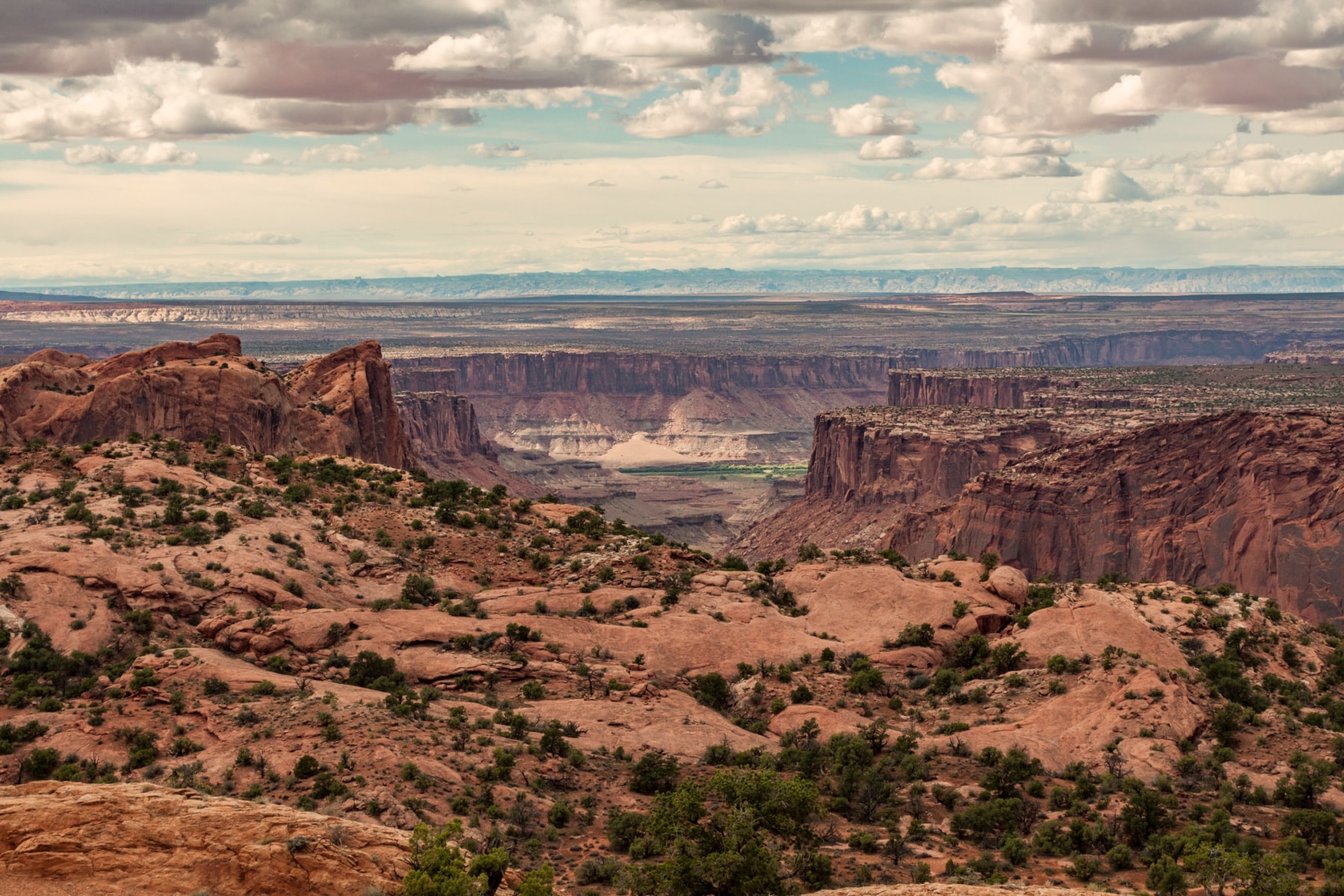
Finally, we reach the Grand View Point of Canyonlands. The Great Island in the Sky mesa peters out at its south end to the ridiculously scenic peninsula of Grand View Point overlooking the Green/Colorado confluence.
This is the culmination of the Island in the Sky District scenery, and the easy walk hitting up two different viewpoints—one of the shortest best hikes in Canyonlands National Park—is accessible to a broad spectrum of park visitors.
To begin with, a short paved path accesses the first viewpoint, and then the trail descends to bare sandstone to reach a second vantage. Subsequently, the far-reaching vistas sweep from the White Rim, the garden of spires called Monument Basin and the deep cuts rivers far beyond the Needles and the Maze.

Map of Best Hikes in Canyonlands National Park
Summary of Best Hikes in Canyonlands National Park
- Grand View Point
- Chesler Park/Joint Trail Loop
- Mesa Arch
- Salt Creek Canyon Trail
- The Chocolate Drops
- Druid Arch
- Aztec Butte
- Upheaval Dome Overlooks
- White Rim Overlook Trail
- Whale Rock
- Slickrock Foot Trail
- Gooseberry Trail
Pin Best Hikes in Canyonlands National Park


Helpful Related Articles
Utah National Parks Road Trip: 5 Best Utah National Park Road Trips
Things to Do Bryce Canyon: 20 Epic Things to Do in Bryce Canyon National Park
Zion National Park Guide: Ultimate Guide to Zion National Park
Things to Do in Zion: 18 EPIC Things to Do in Zion National Park
Best Hikes in Zion: 16 EPIC Hikes in Zion National Park
Angels Landing: Complete Guide to Hiking Angels Landing
Things to Do in Arches: 16 EPIC Things to Do in Arches National Park
Best Hikes in Arches: 12 Best Hikes in Arches National Park
Utah’s Manti-La Sal National Forest: Manti-La Sal National Forest: The Forest As Beautiful as Utah’s Parks
Leave a Reply