We’ve spent years behind the wheel on national park road trips, from the Pacific Coast to the Florida Keys and everywhere in between. The routes we know best are the ones that combine great driving with great parks. This guide is built from that experience.
I’ve driven across and around Colorado for years, yet I still feel like I’ve hardly scratched the paved surface of ultimate exploration. I’ve even taken some wrong turns that can help you avoid my driving disasters.

Things to Know Before Your Colorado Road Trip
I grew up in the Midwest, where a mountain meant the Ozarks, and high altitude was only something you could find flying out of Missouri. If you’ve never taken a road trip to Colorado approaching from the east, I have some disappointing news. the mountains don’t start at the Colorado state line.
In fact, you have about 200 miles of flatter land that feels like 2,000 miles as you strain your eyes to see peaks over the plains.
The most beautiful weather of my life was experienced in Colorado. The most fearful I’ve ever been on the road was also in Colorado. No two roads are the same, and even interstates have some white-knuckled twists and turns. I hope my wanderlust and haphazard luck patterns can help you along your chosen path.
Colorado Road Trip Weather
It helps to understand the different climate zones that will impact your adventure on a Colorado Road Trip.
High Plains (Eastern Colorado)
Eastern Colorado, often referred to as the High Plains, is known for its semi-arid climate. This region experiences extreme temperature variations throughout the year, making it a land of contrasts.
- Summers: Hot and dry, with temperatures frequently soaring above 90°F (32°C). Be prepared for scorching days if you visit during this season.
- Winters: Cold and snowy, with temperatures frequently dropping below freezing. Snowfall is common during the winter months.
Front Range (Denver, Colorado Springs, Pueblo)
Moving westward into the Front Range region, which includes Denver and Colorado Springs, you’ll encounter a different climate profile. This area enjoys four distinct seasons, offering a more temperate experience.
- Summers: Warm to hot, with daytime temperatures ranging from 70°F to 90°F (21°C to 32°C). Expect sunny days that beckon outdoor exploration.
- Winters: Cold and crisp, with temperatures usually hovering between 30°F to 50°F (-1°C to 10°C). Snowfall, though less intense than in the mountains, graces this region during winter.
Rocky Mountains (Central Colorado)
As you venture into the heart of Colorado, the Rocky Mountains, the climate transforms into a more alpine environment. Here, you’ll discover cooler temperatures and increased precipitation.
- Summers: Cool and refreshing, with daytime temperatures ranging from 60°F to 80°F (15°C to 27°C). Ideal conditions for hiking, biking, and exploring the stunning landscapes.
- Winters: Cold and snowy, with temperatures typically between 20°F to 40°F (-6°C to 4°C). Snow blankets the mountain towns, creating a winter wonderland for skiers and snow enthusiasts.
Western Colorado (Grand Junction, Aspen, Durango)
Western Colorado, encompassing regions like Grand Junction, Aspen, and Durango, offers a unique semi-arid climate that combines elements of desert and mountain environments.
Temperature:
- Summers: Warm and dry, with daytime temperatures frequently exceeding 90°F (32°C).
- Winters: Milder compared to the mountains, with daytime temperatures ranging from 30°F to 50°F (-1°C to 10°C). Snowfall occurs but is generally less intense.

Colorado Road Trip Requirements
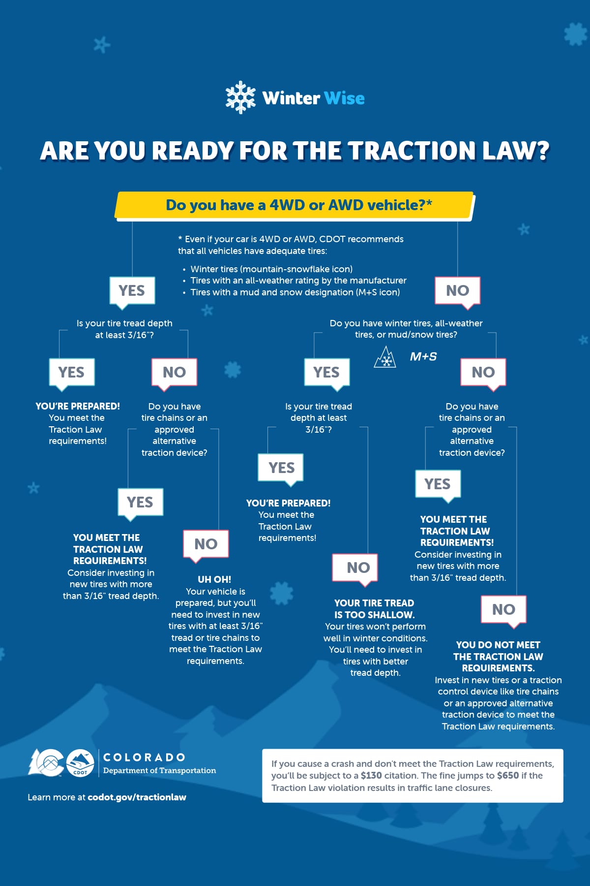
The best-planned Colorado road trip can’t start without the right type of vehicle. In fact, Colorado has a Traction Law that applies to residents and visitors, even if you’re getting a rental car. During winter storms, the Passenger Vehicle Chain Law goes into effect.
You can get fined if you don’t follow the traction law. Meanwhile, it’s wise guidance any time of year for any Colorado Road Trip. I took a cross-state trip in the summer of 2017 in an old Toyota Celica convertible. At times, I wasn’t sure if we’d make the next incline (we did, that car was a beast!).
The Traction Law Guidance is good for any time of year driving through Colorado.
- Get an AWD or 4WD Vehicle.
- Check that tires have 3/16 of an inch tread depth.
- Have tires with an all-weather rating or snow tires with 3/16 of an inch tread depth.
As of 2019, Colorado’s laws also require that from September 1 through May 31, the traction law is always in effect on I-70 from Dotsero to Morrison, and tires must have a tread depth of 3/16 of an inch. Here’s a full list of approved All-Traction Devices.
Supply List for Colorado Road Trips
We invite you to bookmark our list of Road Trip Essentials & Packing before you head out on any road trip. I can’t tell you how many times my car battery jump starter has paid for itself in convenience, as my Subaru had a bad battery that was easily replaced (and under warranty).
I don’t want to waste your time with the essentials, but a few aspects of Colorado warrant emphasizing.
- Bear Necessities: This is bear country; your food should always be in bear-proof containers. Use bear-proof trash cans at rest stops to limit the scent coming from your vehicle. Each person should also have their own bear spray that is easily accessible. For example, hook it to your hip.
- Sunscreen: You want any exposed skin (yes, even that arm hanging out the window) to be covered in Eco-friendly sunscreen. Don’t forget lip balm with SPF.
- Cardboard: A few flats of cardboard or carpet won’t take up much car space but can easily help get a car out of a snow bank or muddy spot.
- Altitude Sickness Medication: It’s one thing to feel lightheaded and descend a hike. You don’t always have that option on a Colorado road trip. Use this handy guidance from the CDC to find the right medication and treatment for mild to life-threatening high-altitude illnesses.
- Dramamine: This can help anything from vertigo to car sickness. I can’t go anywhere without mine. I’m not a fan of heights, and one little dizzy spell can ruin my day.
- Bright Red Something: I have a stash of red towels I picked up at a post-Christmas sale that always stays in my car. These are great flags for breakdowns in the snow or low-visibility weather.
Car Maintenance for Colorado Road Trips
The higher elevations can also make your car deal with altitude sickness. Expect your car to lose about 3% of its engine power with every 1,000 miles you climb.
- If you’re driving your own car, get a full inspection of all systems and top-off fluids.
- Confirm that your spare tire is inflated (I made that mistake once).
- Finally, bring extra windshield washer fluid and a clean air filter in case you go through debris from wildfires or cars kicking up salt/sand/mud/snow/ice.
“Unlike normal wear and tear that’s compounded over time, altitude effects build as soon as the vehicle starts to climb. The reduced oxygen means that your engine struggles to intake enough air to feed itself. This can lead to inefficient and even sluggish performance. If it’s not tuned correctly, it can impact everything from towing capability to acceleration.”
AAMCO Colorado
Every time you stop for gas, check the tire pressure. That’s because the change in elevation and temperatures can impact the pressure.
Are You a No Gas Getter on Road Trips?
I need to know if I’m the only human out here who does this, but I live in a world where OF COURSE, there is another gas station up the road. Is it REALLY “57 Miles Until Next Gas Station”? That seems excessive. Once I’m in a groove, I don’t like to pull over and ruin all the work it took to bypass that chain of semis coming up the hill to Vail.
This awful habit has only burned me once, but it won’t again. Especially if you are heading off the interstate to one of the 26 scenic byways listed below, stop to get gas. As a rule of thumb, fill up when you get to half a tank. You never know when an accident will leave you idling in a winter storm or record heat.
DID YOU KNOW? Speaking of gas, did you know that you will flatulate and urinate more at high altitudes? In fact, less frequent urination could be the first sign of dehydration. At the same time, the increased frequency of flatulence is known as HAFE (High Altitude Flatus Expulsion) and starts acting up around 11,000 feet.
Electric Charging Vehicle Stations in Colorado
Colorado has more than 1,500 locations to charge a vehicle, either at Level 2 or DC Fast Charging. The total number of ports is around 3,300.
Here are some resources to help plan a Colorado road trip with an electrical vehicle.
- EV Match: Pair up with homes, businesses, and other housing that allows you to charge a vehicle. It’s like booking a rental home but for your vehicle.
- Alternative Fuel Locator: A list of all locations in Colorado.
- Plug Share: Create a free account to map charging stops along the way.
Colorado Road Trip Resources
It’s important to note how quickly weather conditions can change in Colorado. That goes for any season. A clear day can quickly turn dark and stormy. You’ll also be sharing the major interstates and highways with semi-truck drivers.
- COTrip.org is a website and app you can use to plan your trip, check live cameras, get real-time traffic, look for construction zones, or track disruptive weather. Create your own account and set your routes to get alerts.
- Motorcycle drivers should review the resources available, complete with a map of skill ratings on various roads.
- Winter drivers should track the snow plows throughout the state.
- This helpful map from CODOT offers mile markers across the state, along with recreational opportunities and regional guidance. Here’s the backside of that map.
You can dial 511 at any time from your mobile device to get travel information statewide.
DID YOU KNOW? If you’re using Google Maps to plot your course, you can download maps of National Park Service properties to use offline. That means you’ll have mapping abilities even when you don’t have an internet connection. We find this works for most federal lands, but you might find local and state parks in there too.
Click on the image below to open a new window with our top FREE Road Trip Planning Tools and Apps.
Wildfire Dangers in Colorado
I’ve twice been to Colorado during devastating fires for work to help with local news management. My first one was near Colorado Springs. I remember driving down I-25 thinking, “Oh! There’s a thunderstorm! I hope that rain will help with the fire.” Only it wasn’t a thunderstorm. It was the massive cloud of the wildfire creating its own weather.
While it was my job to drive near that fire, you don’t want to take that same risk when you’re taking a Colorado road trip.
Here are some tools to help you out:
- Wildfire Risk Map: Create your own outline to find out the fire risk along your route or recreational activities.
- Active Wildfire Map: A map showing the areas where active fires are burning. Click on each incident to get more information.
- BLM Colorado Fire Dashboard: List of fire restrictions, prescribed burns, and other fire information across the state.
- Colorado Air Quality Alerts: Wildfire smoke can cause air quality alerts, tough breathing conditions, and limited visibility. You can sign up for alerts about air quality in the link.
Colorado Road Trip Camping
From the backcountry to bougie, camping options span the entire state and several different governing bodies of rules.
- National Park Service Campsites Across Colorado: Usually requires a reservation and can also be full months in advance.
- Forest Service Campsites: You’ll likely have better luck (and looser restrictions) when choosing a Forest Service campsite.
- BLM Recreation Guide: Come and go as you please, but follow the liberal rules of BLM campsites in Colorado.
- Campgrounds Across Colorado: Other campsites outside of NPS properties, either at local or state-owned parks.
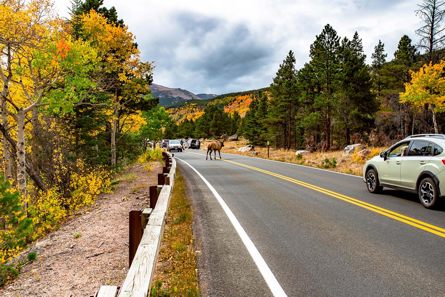
You’ll want to review the basics, such as how to fend off a curious bear and what to do if you stumble upon a bulging elk during the rut. It is always illegal to feed, harass (even making a noise to get an animal’s attention is considered harassment), or touch wildlife, even if they appear injured. Even if they are really cute. Always.

Colorado Road Trip Night Sky Viewing Map
I do a lot of yoga but never really grasped the “be at one with the universe” until I saw the night skies of Colorado. More than a dozen locations in Colorado are designated Dark Sky Parks or Dark Sky Communities. Most are well south of I-70 and make a great excuse to extend your Colorado road trip to the southern state section or down less-traveled roads.
Colorado Road Trip Highlights
As stated above, road closures can have an impact and that goes well into spring. Most roads closed in the winter don’t open until around Memorial Day. Concurrently, early spring brings some of the largest snow totals of the year, and snow can fall well into May.
When is the Best Time of Year to Plan Your Colorado Road Trip?
Certainly, there isn’t a bad time of year to road trip across Colorado. You will find the pros and cons of all four seasons.
Winter
First of all, you should check the annual closures for winter in Colorado. No matter what the weather conditions, these locations will close from late fall through late spring.
- Virginia Dale Rest Area on US 287
- Mount Evans on CO 5
- Independence Pass on CO 82
- Cottonwood Pass in Chaffee/Gunnison Counties in Southwestern Colorado
- Kebler Pass
- US 34/Trail Ridge Road
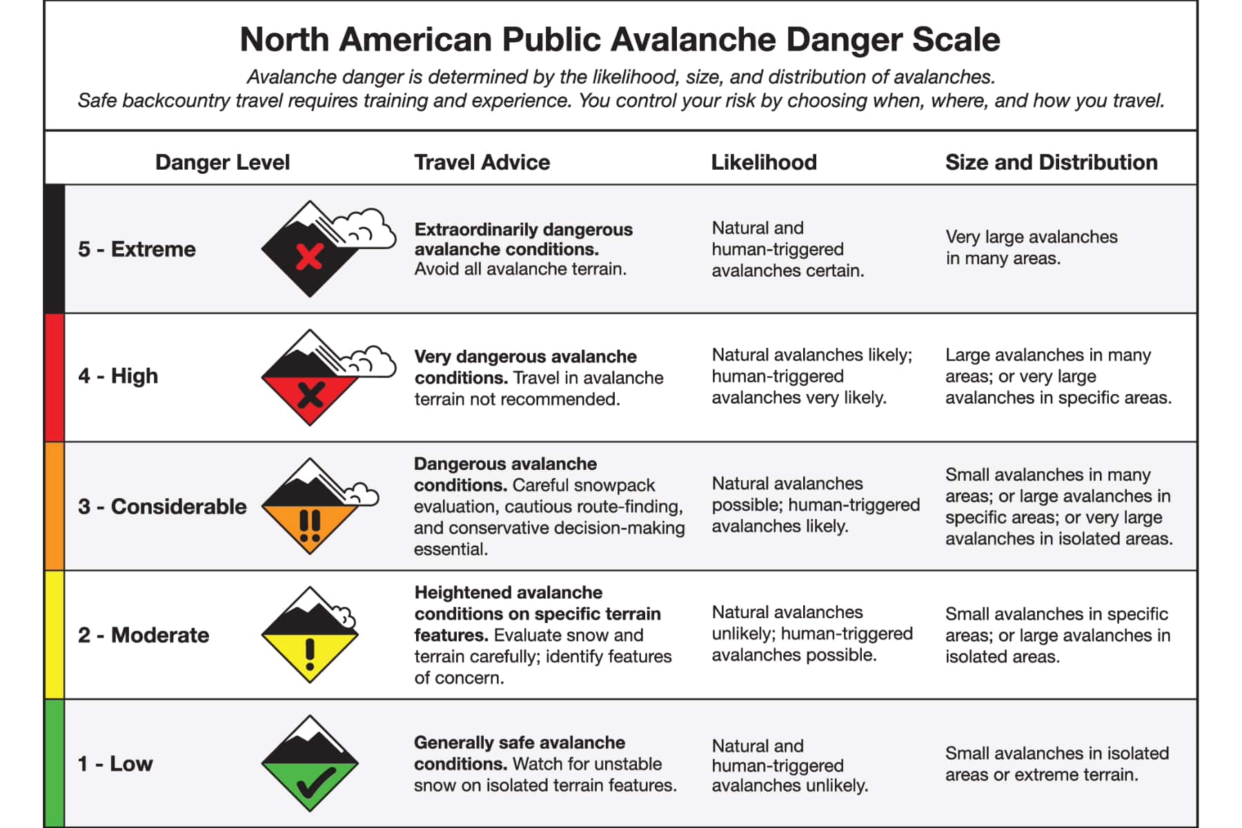
It’s essential to know the avalanche risk on your Colorado road trip itinerary. Colorado roads have more than 500 areas known to be avalanche-prone.
Spring

On the other hand, the Eastern Plains are blooming wildflowers in April and May. Higher elevations in the Rockies won’t get those blooms until July or August. A 4th of July Colorado road trip poises to offer the best blossoms in the higher elevations.
Wildfire Season: The official wildfire season is said to run from May through September, but wildfires can happen any time of the year. They are more frequent or more intense in late spring through early fall.
Summer
By and large, summer follows the calendar in Colorado, kicking off at the summer solstice and running through early September. The peak summer travel season also spans those months, with no real “low tourist weekend” in that timeframe.
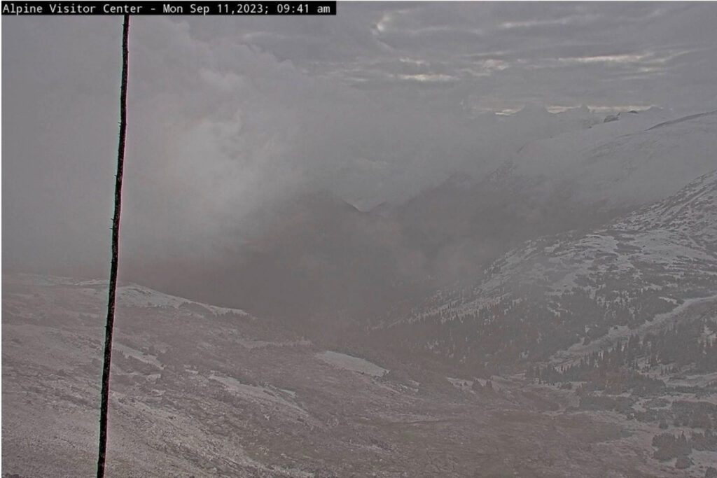
Winter can sneak past fall sometimes, with snow falling in early September as it did in 2026.
These smaller storms can be inconvenient for Colorado road trip tourists as roads can close without much notice. As noted above, that’s one reason it’s important to check weather and road conditions on each leg of your trip.
Summers can also be incredibly hot, “but it’s a dry heat,” and then cool to cold at night.
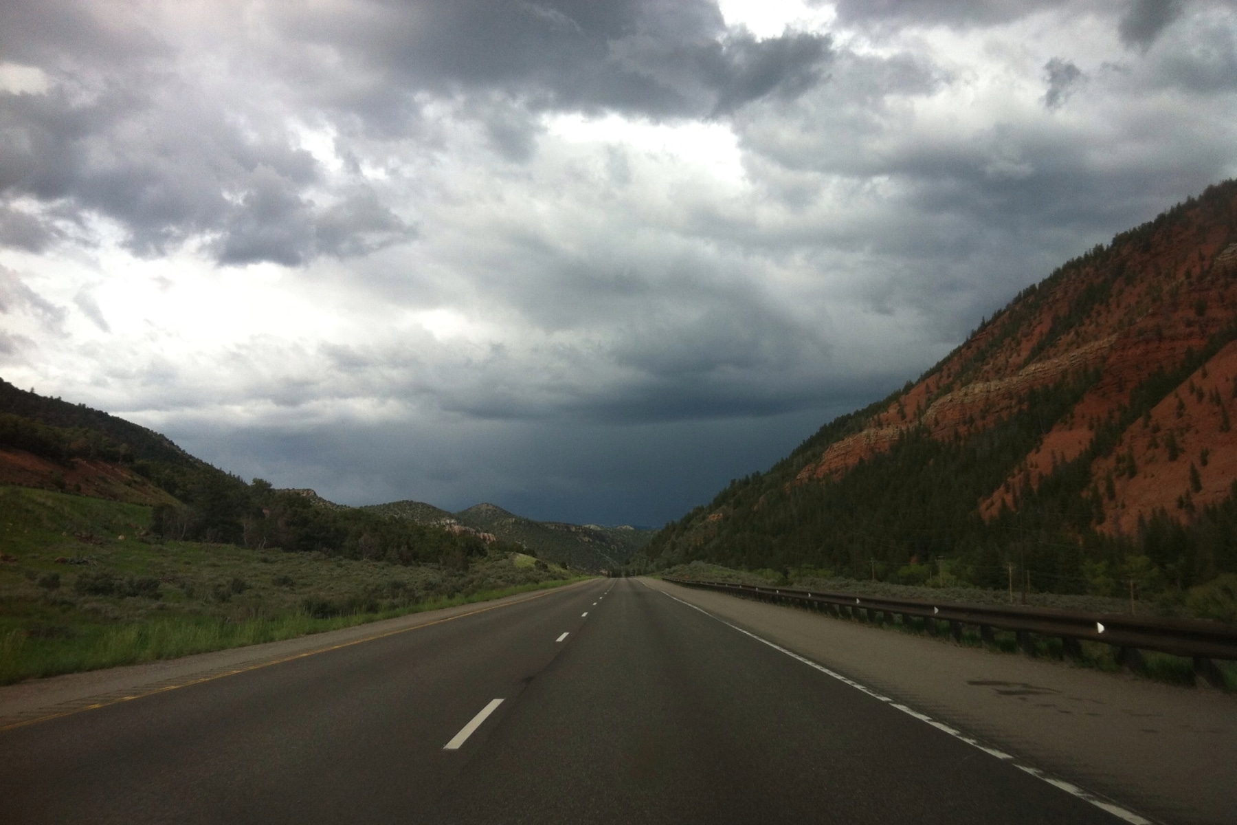
Thunderstorms can build quickly in the mountains and be intense at times. The photo below shows a storm that developed ahead of me, and I thought I was pacing well behind it, only to end up in a tornado warning while stuck in Denver traffic.
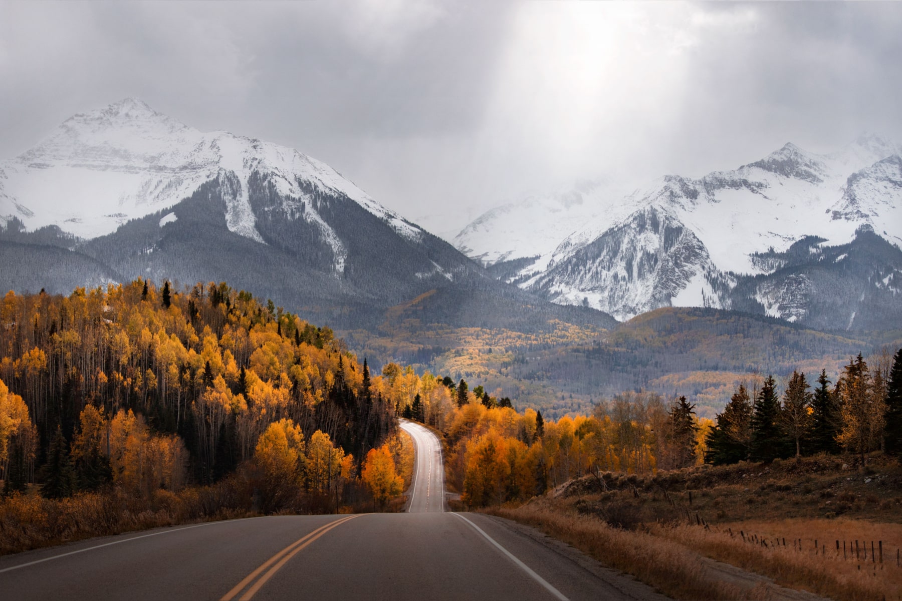
Fall
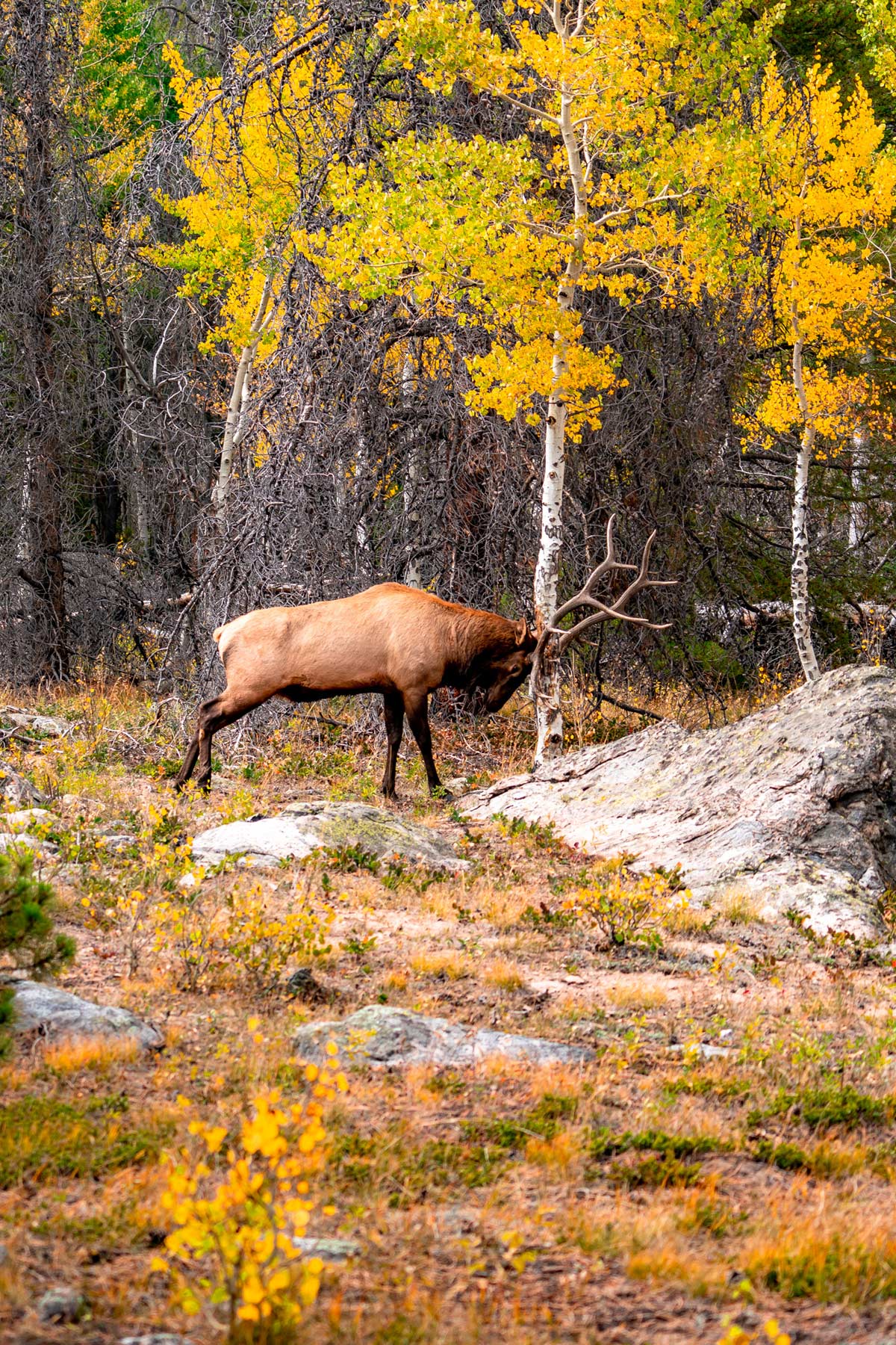
The word “leaf-peeping” does to my brain what the word “moist” does to others. So we’re going to call it fall foliage. Either way, the leaves begin to change throughout September, with the higher elevations evolving first.
Southern Colorado might have that peak stretch into October, but there’s a 10 to 20-day window to experience the best views. Each year is slightly different, depending on weather patterns, moisture, and temperatures going back to the previous winter.
The Colorado State Forest Service offers great advice on planning a Colorado road trip to see fall colors.
Pack plenty of base layers and insulated and/or waterproof outer layers, as one day can feel like summer and the next like winter.
List of Colorado Scenic Byways
As much as we want to see everything on road trips, it’s really not feasible unless you’re retired or living the RV life. In either event, I’m jealous of you!
We’re going to break down the 26 scenic byways for your Colorado road trip by section of the state.
Southwest Colorado Scenic Byways
Six scenic byways run through the southwest part of the state:
Alpine Loop
Length: 63 miles
Drive Time: 4-6 hours
Seasonal Closures?: Closed in Winter, Mud potential year-round
4WD Required?: Yes
Colorado Electric Byway? Yes
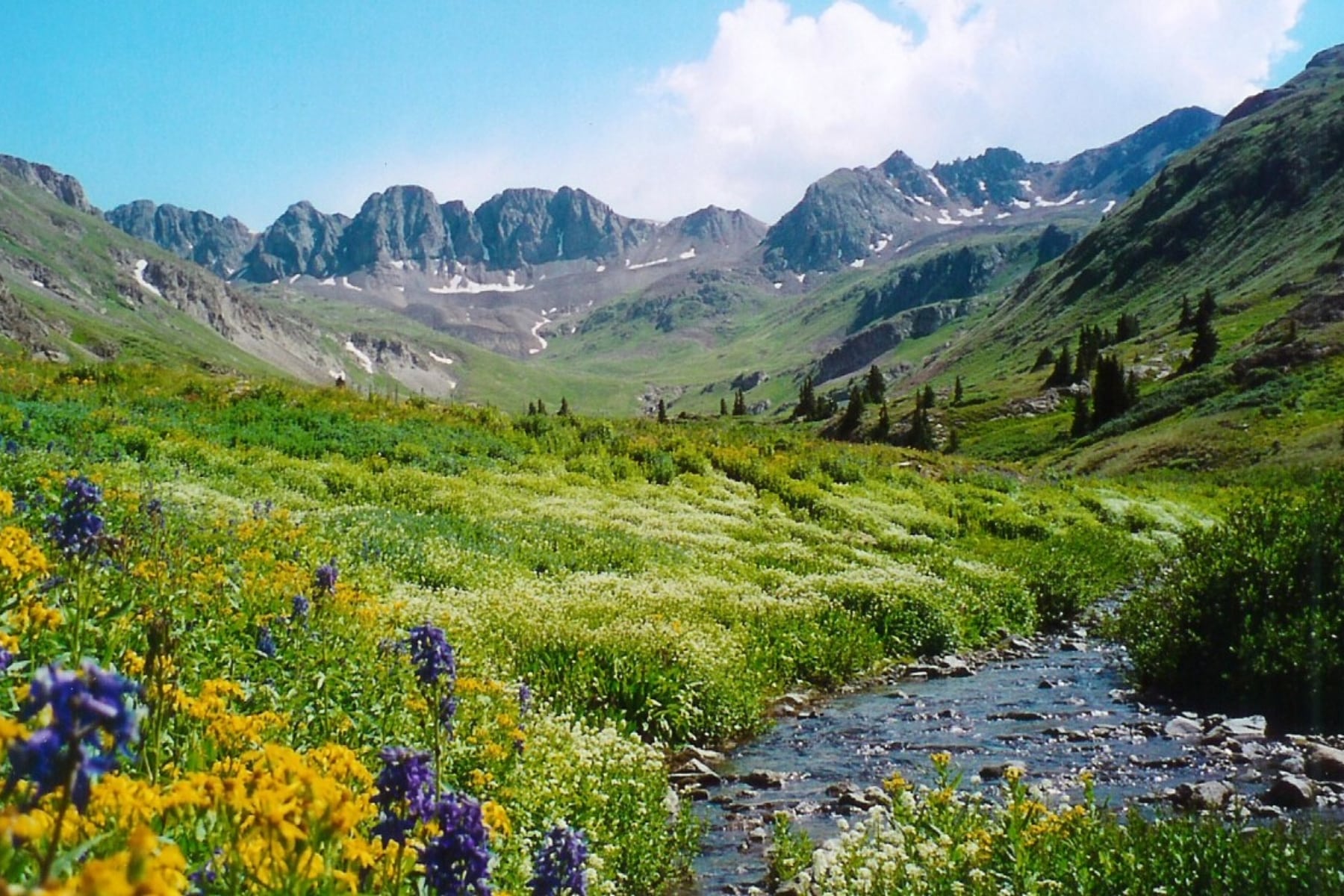
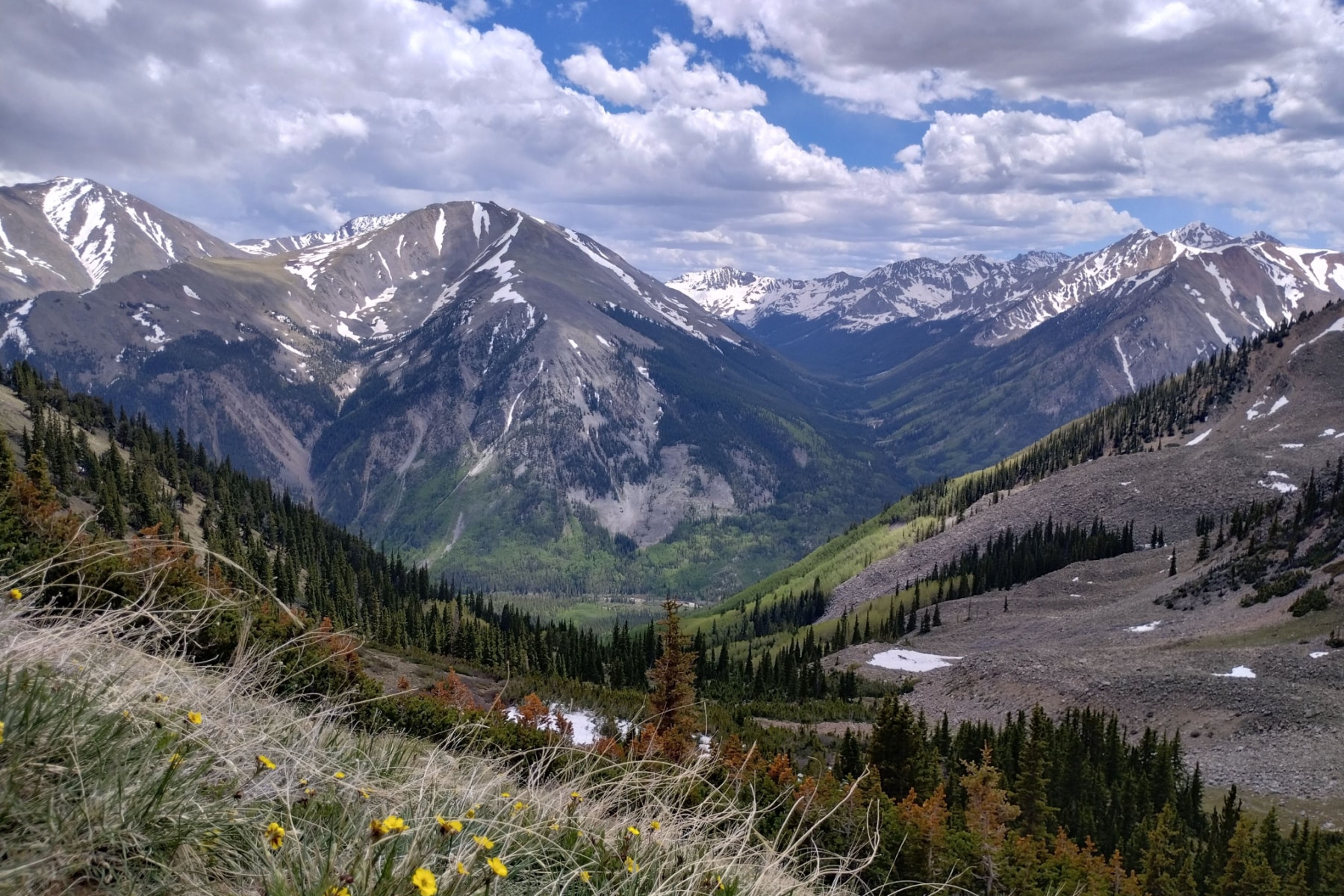
Following a rugged path from Silverton to Ouray, you’ll go through San Juan National Forest along roads once trekked by miners. In addition to the wonderful views from the 12,000+ peaks at Cinnamon and Engineer mountains, you’ll find waterfalls, ghost towns, and historical sites bookending the Alpine Loop.
West Elk Loop
From dinosaurs to dynamic Rocky Mountain National Park scenery, northwest Colorado includes four scenic byways, one that takes you right to an RMNP entrance.
Length: 205 miles
Drive Time: 6-8 hours
Seasonal Closures?: More than 30 miles over Kebler Pass closed in winter.
4WD Required?: No, but AWD or 4WD is helpful.
You’ll use part of the West Elk Loop to get to Black Canyon of the Gunnison National Park, so why not take the full ride? The drive includes Mount Sopris and Black Canyon summits. In addition, you’ll pass through the Colorado towns of Hotchkiss, Crawford, Gunnison, and Crested Butte.
Other public lands on the way include White River and Gunnison National Forests and Curecanti National Recreational Area.

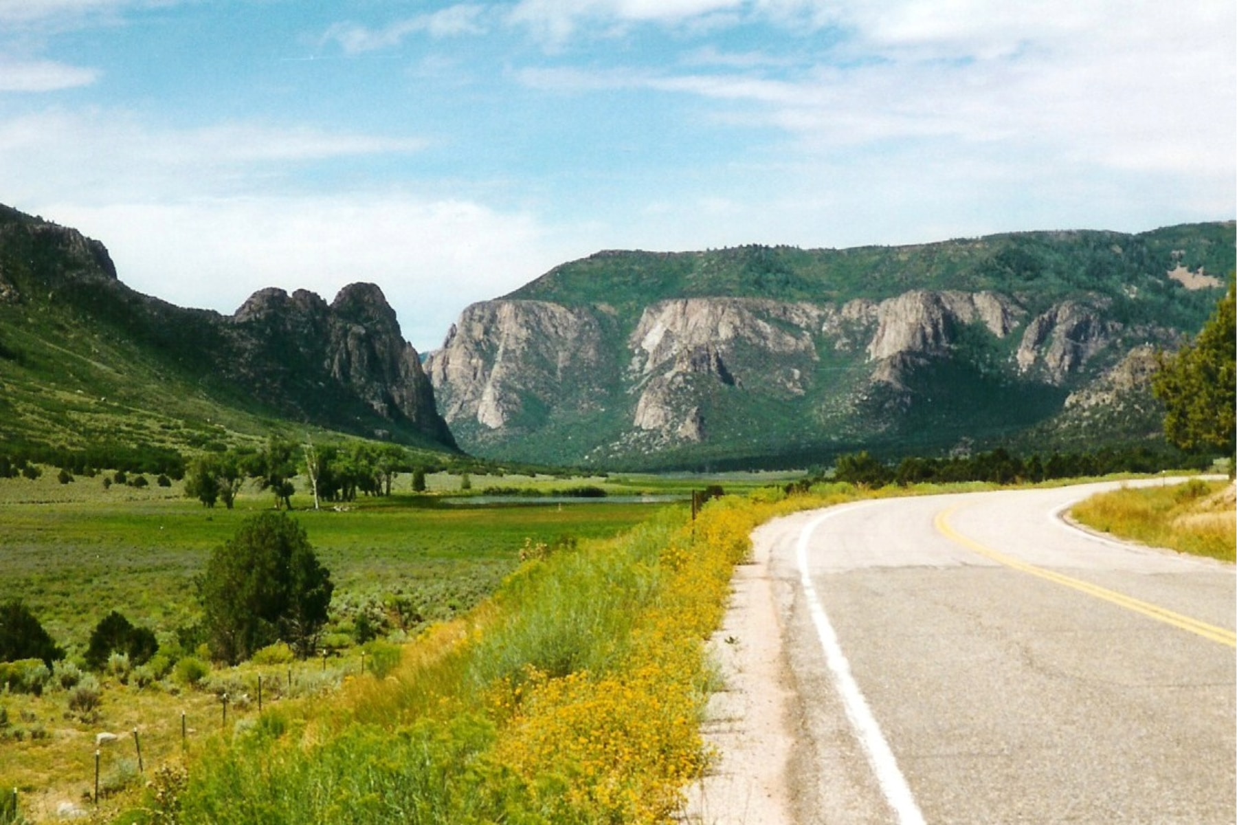
San Juan Skyway
Length: 236 Miles
Drive Time: 6 Hours
Seasonal Closures?: Possibly, check road conditions
4WD Required?: No, but AWD or 4WD preferred
Indeed, this is one of the best scenic byways for a Colorado road trip. You’ll have several public lands along the way. For example, Mesa Verde National Park and Canyon of the Ancients (BLM). Meanwhile, you’ll pass through epic towns like Telluride,

Tracks Across Borders
Length: 89 miles in Colorado, 125 miles between Colorado and New Mexico
Drive Time: 2.5 hours
Seasonal Closures?: Possibly
4WD Required?: No
Historic stories of Indigenous people and the narrow gauge railroad cover this scenic byway. The first thing to remember is to respect tribal lands. It’s also worth noting that those lands have their own law enforcement. Chimney Rock National Monument is a must-see on this Colorado road trip.

Trail of the Ancients
Length: 116 miles
Drive Time: 6 hours
Seasonal Closures?: Possibly
4WD Required?: Preferred. Muddy sections and gravel surfaces present
Not only does the Trail of the Ancients take you through ancestral Pueblo land, but you’ll get several public lands along the way to highlight the lifestyles we can only interpret through stories passed from generations.
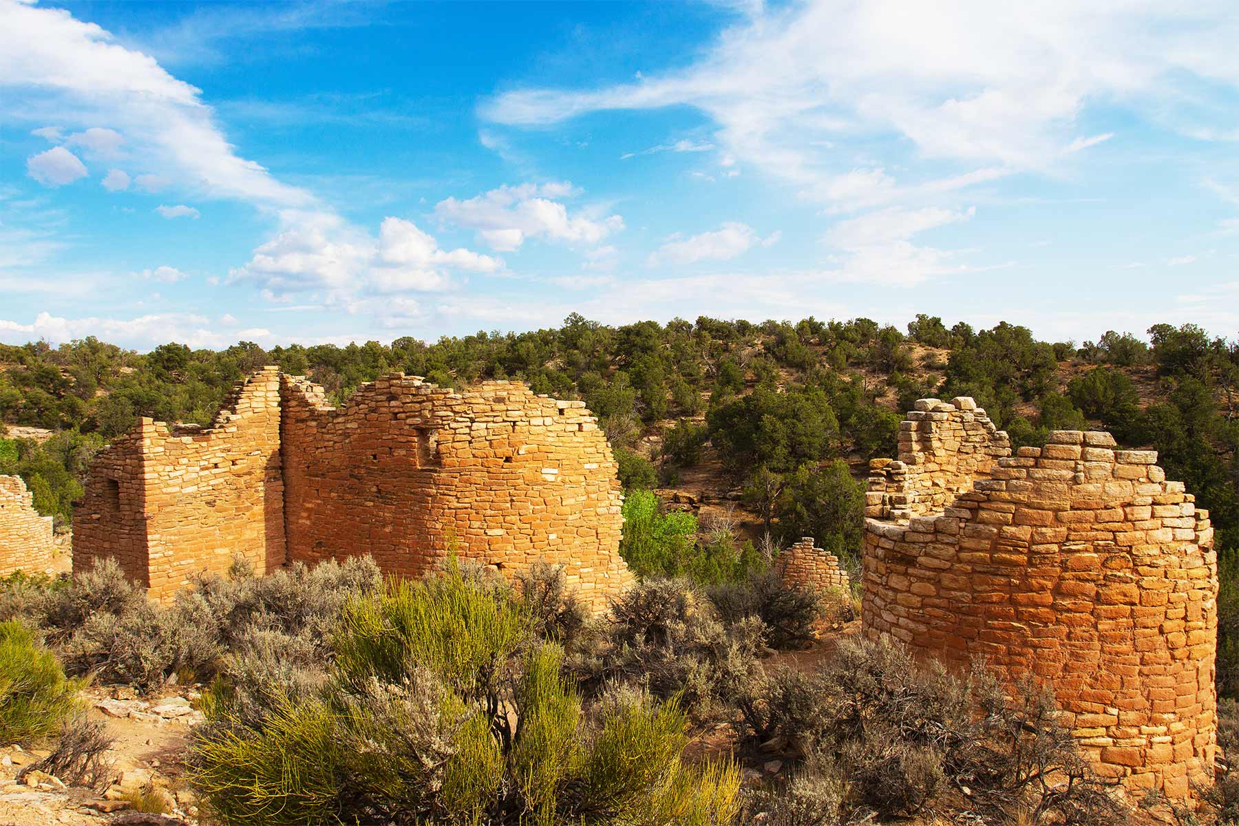
Along the way, you’ll pass Mesa Verde National Park, Hovenweep National Monument, and Canyon of the Ancients (BLM). The byway takes travelers to the Four Corners area, and the road continues into Utah.
Unaweep/Tabeguache
Length: 133 Miles
Drive Time: 3 Hours
Seasonal Closures?: Possibly
4WD Required?: No, but AWD or 4WD is preferred.
Known as the UTB, this scenic byway hugs around the remote western edge of Colorado. History and cultural lessons are balanced against a slew of recreational activities. The coloring of UTB reminds you of the best parts of the Grand Canyon, Zion National Park, and the Rockies.
Dinosaurs once roamed this land, and cultural landmarks dot the landscape. Canyon rivers and sheer, ominous cliffs await, with a history of mining copper and ore behind the rock walls.
Map of Southwest Colorado Scenic Byways
Santa Fe Trail
Length: 188 Miles
Drive Time: 4 Hours
Seasonal Closures?: Possibly
4WD Required?: No
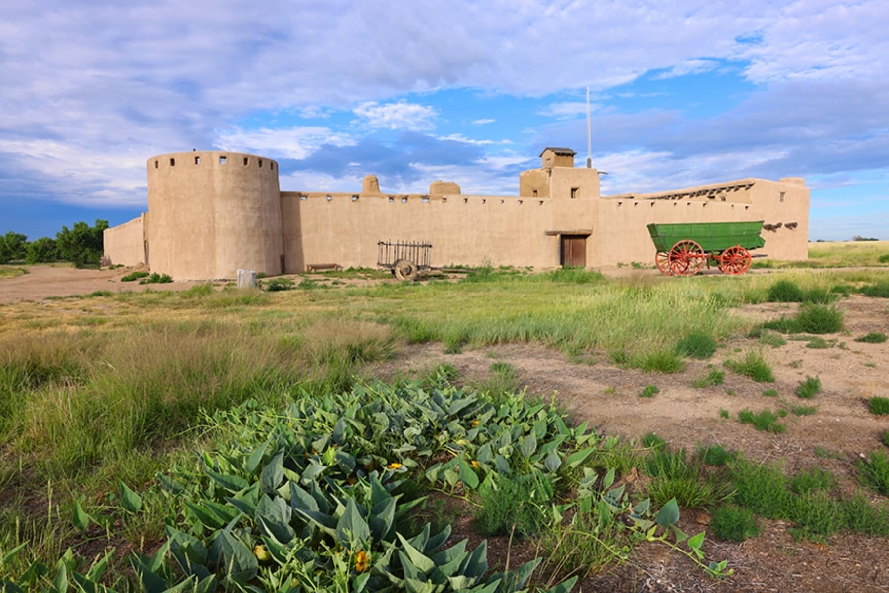
All of a sudden, you realize you’re on the same path that wagons once took on this famed trade route of the 1800s. About halfway through the drive, you’ll come to Bent’s Old Fort National Historic Site. Mountain passes included Trinidad and Raton Pass, and farmers will seasonally be selling goods along the roadside.
The full Santa Fe Trail runs from Boonville, Missouri, to Santa Fe, New Mexico, covering 900 miles and five states.
South Central Colorado Scenic Byways
Finally, to wrap up the southern part of the state, we’re looking at the South Central sections of the Colorado road trip scenic byway options.
Collegiate Peaks
Length: 57 miles
Drive Time: 90 minutes
Seasonal Closures?: Possibly
4WD Required?: No, but some side roads might require it.
Colorado Electric Byway? Yes
Collegiate Peaks Scenic Byway takes you through an Ivy League of 14,000-foot mountain peaks in less than two hours. The best time to ride the Collegiate Peaks Scenic Byway is in the fall when foliage explodes with colorful spectrums adoring different elevations.
Follow the road to the Arkansas River to explore rafting and kayaking hot spots. At the same time, you can go off the beaten path to ghost towns like St. Elmo. Tired of hiking or sitting in a car? Try out the various hot springs along the way.
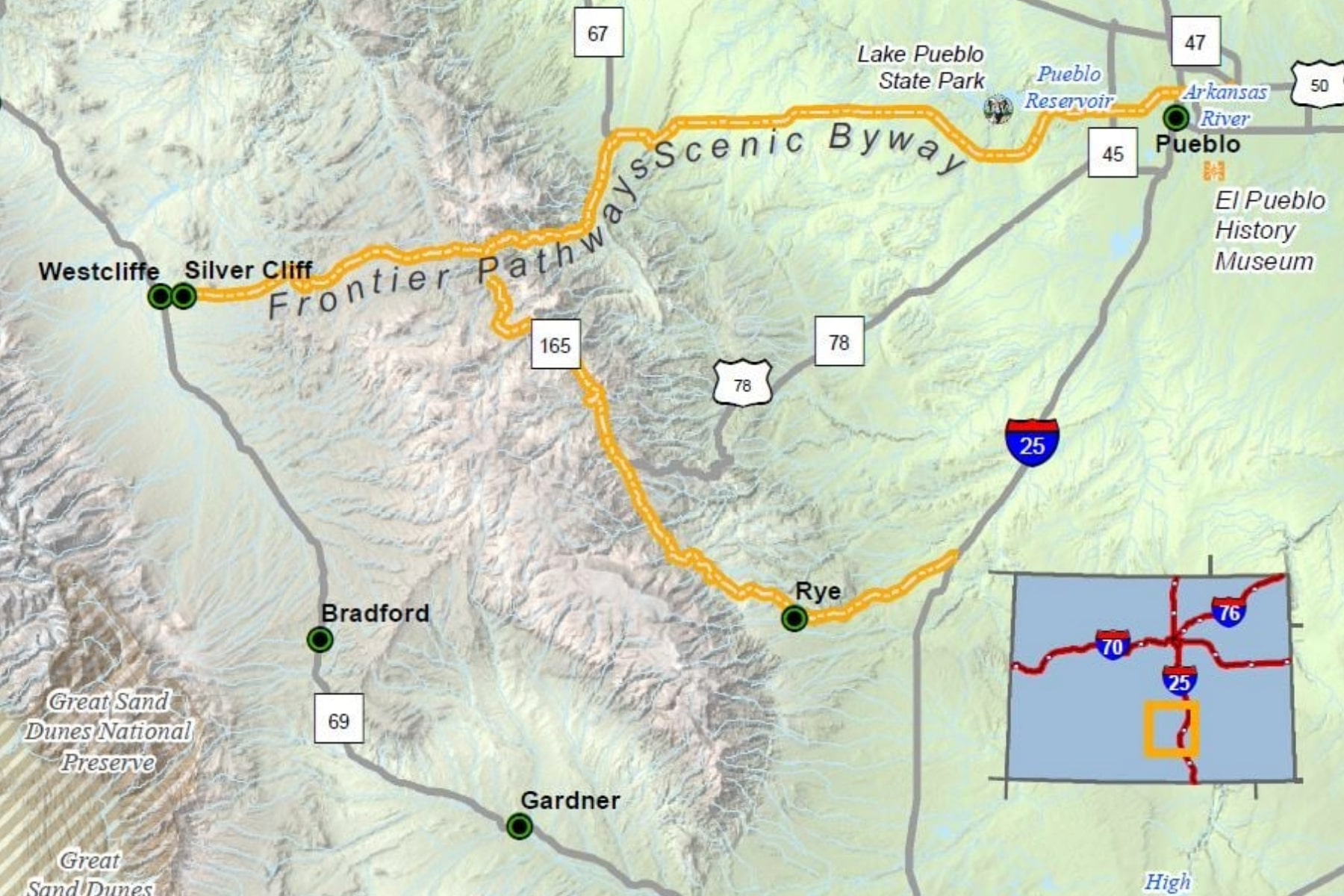
Frontier Pathways
Length: 103 miles
Drive Time: 3.5 miles
Seasonal Closures?: No, but check conditions
4WD Required?: No
By all means, join the thousands of people who’ve walked or ridden this stretch of Colorado. It’s called the Frontier Pathways since Indigenous people, Spanish, French, settlers, and Gold Rush hunters all came through this storied land.
Mountain peaks and wide meadows meet you along the way, with historical markers telling stories of those who came before you. Pueblo is a great home base for this road trip, which also covers part of the San Isabel National Forest.
Gold Belt Tour
Length: 131 Miles
Drive Time: 5 Hours
Seasonal Closures?: Possibly
4WD Required?: Yes, on the Upper Shelf. Phantom Canyon Road limits vehicle size to 25 feet.
To begin with, you’ll see the Florissant Fossil Beds National Monument. The byway takes you through historic gold towns like Cripple Creek, Florence, McCourt, Wilbur, and Victor.
I highly recommend staying a night or two in Canon City, where the Royal Gorge is found with “America’s Bridge” spanning the chasm. If you have a fear of heights, take a railroad tour or go for a rafting trip instead.
TRAVEL TIP: Avoid Shelf Road if you don’t have a 4WD or have a problem with narrow, 200-foot drops off sheer cliffs from a rock/dirt road. If that’s your thing, you’ll find epic rock-climbing locations along the way.
Los Caminos Antiguos
Length: 129 Miles
Drive Time: 3 Hours
Seasonal Closures?: Possibly
4WD Required?: No
Staying in the car becomes hard when you’ve got a great place like Great Sand Dunes National Park to explore along the way. The towering sand dunes seem like a mirage at first glance. Tucked between the Sangre de Cristo Mountains and the San Luis Valley, surf the sand before getting back in the car.
As the path goes on, you’ll pass through several of the oldest Colorado locations, with markers from the 1600s when the Spanish claimed the territory originally. If you want to park the car for a bit, take a ride on the Cumbres & Toltec Scenic Railroad between Colorado and New Mexico.

Silver Thread
Length: 117 Miles
Drive Time: 3 Hours
Seasonal Closures?: Possibly, especially when off-roading
4WD Required?: In some places, yes.
Colorado Electric Byway? Yes
The mix of mining towns coupled with the off-road and backcountry trail adventures makes this byway a real treat for hikers. The byway follows the route of silver miners back in their heyday.
Tours of mining towns are along the way, some perched at clifftops with others open to underground passage. Be sure to mark North Clear Creek Falls for one of the best waterfalls in the state. You’ll also get a peak at the “14ers”, mountains that top 14,000 feet. Set your GPS to stop at Windy Point Scenic Overlook.
Concurrently, you can explore the waters of the Rio Grande or spend a day fishing.
Top of the Rockies
Length: 115 Miles
Drive Time: 3-4 Hours
Seasonal Closures?: Possibly
4WD Required?: No, but a vehicle that can handle high altitudes is necessary.
Colorado Electric Byway? Yes
You know a scenic drive poises to be a good one when Aspen isn’t even the top three spots to stop on the list. Just 30 miles off I-70, you’ll arrive at the highest incorporated community in America. Leadville sits at 10,200 feet. Comparatively, you’ll still feel small compared to the “14ers” that rise above you. You’ll also cross the Continental Divide in three spots.
This scenic byway also offers the expansive White River National Forest, home to 11 ski resorts, 10 peaks topping 14,000 feet, and eight wilderness areas. You would enter through the Holy Cross Ranger Station.
Northwest Colorado Scenic Byways
Colorado River Headwaters
Length: 80 Miles
Drive Time: 2 Hours
Seasonal Closures?: Possibly
4WD Required?: Yes, if planning to take the road between Kremmling and State Bridge, which is all gravel and limited service or mobile service.
Colorado Electric Byway? Yes
The nearly 1,500-mile Colorado River starts in the humble waters around Grand Lake, where a stream eventually becomes a watery carver of canyons. Grand Lake reigns as the largest natural lake in the state.
You can avoid the gravel section by adding another 15 or so miles using Highway 134. The byway takes you to the Kawuneeche Visitor Center of Rocky Mountain National Park, which is open from late May through the end of October.
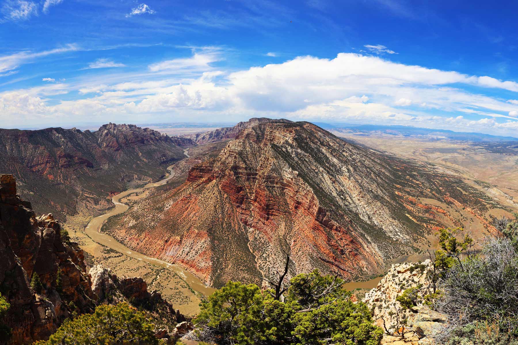
Dinosaur Diamond
Length: 134 Miles (486 miles for the entire Colorado/Utah Route)
Drive Time: 2-3 Days for the entire route, 3-5 hours for the Colorado route
Seasonal Closures?: Possibly
4WD Required?: No.
The Dinosaur Diamond gets its name from the diamond shape it forms around eastern Utah and far western Colorado.
The Colorado side of this scenic byway is an easy drive with a few hairpin turns and the Canyon Pintado National Historic District along the way.
This is a great loop to take if you’re also planning to explore Canyonlands National Park, with the closest entrance being Island in the Sky.
The byway gets its name from the extensive dinosaur fossils found in this region, including several museums and historic locations along the way. This Colorado adventure includes long stretches of lonely road, the purest form of a Colorado road trip.
Flat Tops Trail
Length: 82 Miles
Drive Time: 2 Hours
Seasonal Closures?: Yes. Closed in winter from Dunkley Pass on the east to mile marker 31 on the west.
4WD Required?: No, but a long stretch is on a gravel road. 4WD is helpful if it’s muddy or rainy.
You can start this as a road trip, but you’ll have a hard time staying in the car if you love the outdoors. Outfitters offered along the scenic byway will take you on day hikes, multi-day backcountry hikes with hot meals, and horseback riding.
As part of the Flat Tops Wilderness Area, you’ll cruise above 10,000 feet through the second-largest protected piece of land in Colorado. This is also a great byway to see wildlife since development is not permitted on this land. Be sure to add the Trappers Lake spur road to your road trip itinerary when taking Flat Tops.
Grand Mesa
Length: 63 Miles
Drive Time: 2 Hours
Seasonal Closures?: Possibly
4WD Required?: No. Services are limited between Cedaredge & Mesa.
Colorado Electric Byway? Yes
I’ve taken this drive several times, more as a functional road to get to family in Cedaredge, but the views never fail to impress. You’ll turn off I-80 through Plateau Creek before climbing to 11,000 feet above sea level through forests and lakes.
There are a few nail-biting turns on the road. Luckily, I’ve only taken the trip in the summer when the roads are clear, but there’s always still a little snow in the shadows.
The Land’s End Observatory sits at the end of a winding and gravel/dirt road on Grand Mesa. In warm weather, it’s doable with a regular vehicle. However, at least AWD helps. I can’t even use words to give the view justice, so here’s a picture.
Northeast Colorado Scenic Byways
The flatter parts of the scenic byways are in this quadrant, and anyone who’s driven the eastern edge of Colorado to Denver knows you can use ANY excitement along the way.
Pawnee Pioneer Trails
Length: 128 Miles
Drive Time: 3 Hours
Seasonal Closures?: Possibly
4WD Required?: No, but watch out for trucks and rocks kicked up on this road.
The anchor towns of this northeast Colorado Roap Trip are Sterling, Ault, and Fort Morgan. While it’s hard to compete with mountainous byways, the Pawnee Pioneer Trails is a nice detour off I-80 along the Colorado Piedmont.
You’ll see buttes and seemingly endless grasslands while feeling the gentle slope as the land eventually rises to the Rockies. As you adventure through Pawnee National Grassland, be sure to know the difference between public and private land. Here’s a map to help.
South Platte River Trail
Length: 19 Miles
Drive Time: 30 Minutes
Seasonal Closures?: Possibly
4WD Required?: No
Don’t let the short distance of this trail negate its worth. By and large, anyone who went west in the 19th century throughout the expansion of the United States took this route. A stop on the Pony Express earned itself a monument in Julesburg.
Julesburg was once a dangerous, sinful town. In retaliation for the Sand Creek Massacre, it burned to the ground at the hands of Indigenous people fighting for their land. As part of the Overland Trail, the wickedness grew from the ashes, a far cry from the charming, quaint town it is today.
TRAVEL TIP: If you’re starting your Colorado Road Trip from Nebraska, the Colorado Welcome Center is the perfect place to stop.
All roads to the scenic byways of north central Colorado run through Denver, Boulder, or Fort Collins. This includes the central stretch of the Rockies immediately west of Denver.
Map of North Central Colorado Byways
Cache la Poudre (North Park)
Length: 101 Miles
Drive Time: 3 Hours
Seasonal Closures?: Possibly
4WD Required?: No
Two things are important to know about this route between Fort Collins and Walden. First, it’s along the Poudre, the only “Wild and Scenic River” designated in the state. Second, it’s more than a byway. It’s the only direct way between those cities. That means summer traffic and sharing the rock with truckers.
That’s even more of a reason to go off the road into the water or the trails along the way. You have several public lands to explore:
- Arapaho & Roosevelt National Forests
- Cache la Poudre River National Heritage Area
- Arapahoe National Wildlife Refuge
Guanella Pass
Length: 22 Miles
Drive Time: 1 Hour
Seasonal Closures?: Yes, from late November through late May.
4WD Required?: No, but the road is more rugged without lane markings in most places. It feels more off-roading than it really is.
Colorado Electric Byway? Yes
Starting at I-70 near Georgetown, I have to tell any Lifetime or Hallmark Christmas movie fan that you simply must stop in town. If a movie hasn’t been shot here, then it should be on the shortlist. Both Georgetown and Silver Plume have Victorian vibes with towering mountains in the background.
This road takes you through Mount Evans Wilderness, covering nearly 75,000 acres. While the distance is short, the list of outdoor adventures is not. As the Forest Service oversees this land, you’ll find looser rules compared to national parks (and smaller crowds). You get two of the “14ers” here, too.
Lariat Loop
Length: 40 Miles
Drive Time: 2 Hours
Seasonal Closures?:
4WD Required?: No
Colorado Electric Byway? Yes
Lariat Loop circles the foothills of Denver. It’s the perfect Colorado road trip for those who want to make a lot of pit stops and not have to worry about remote wilderness. The loop only runs 40 miles but could easily parlay into a long day trip or an enjoyable weekend.
The anchor cities surround this loop. First, you start in Golden, where you can drive clockwise or counterclockwise. Either way, you’ll be able to visit Morrison and Evergreen. Pay tribute to Buffalo Bill at the gravesite and museum. Take a train ride at the Colorado Railroad Museum. If heading to the outer reaches of Colorado to see dinosaur fossils isn’t ideal, you have Dino Ridge on Lariat Loop. It’s where the first Stegosaurus remains were found.
Sample the outdoors of Colorado at Evergreen Lake or the Lookout Mountain Preserve.
Mount Evans
Length: 49 Miles
Drive Time: 2 Hours
Seasonal Closures?: Yes, closed in winter.
4WD Required?: No, but length restrictions of 30 feet are in place year-round. Reservations are required even for the scenic byway.
Mount Evans joins the illustrious list of 14ers with one of the only locations where you can drive to the summit. You’ll want a car that can handle an incline with good brakes on the way down. That’s because 28 of these miles climb 7,000 feet on winding and narrow roads.
This once offered only an out-and-back route but now includes a sloppy loop that goes from Idaho Springs to the summit to Bergen Park, or you can take it in the other direction. This is a busy road, even with the timed entry requirements.
Peak to Peak
Length: 55 Miles
Drive Time: 80 Minutes
Seasonal Closures?: Possibly
4WD Required?: No, but many roads off the main scenic byway are gravel, and 4WD would be helpful.
As the oldest scenic byway in Colorado, Peak to Peak Scenic Byway might also be the most epic. You ride the ledge of the Rockies Front Range. Along the way, public lands adorn the landscape. Here’s a map to find the vehicle restrictions and off-road allowances along the way.
The road goes from Black Hawk to Estes Park, with a collection of parks, trails, ghost towns, and Continental Divide views.
Public lands on this route include:
- Rocky Mountain National Park
- Arapaho National Forest
- Indian Peaks Wilderness Area
NOTE: The National Park Service oversees Rocky Mountain National Park, while the other two are under the Forest Service umbrella.
Trail Ridge Road: Rocky Mountain National Park
Length: 48 Miles
Drive Time: 2 Hours
Seasonal Closures?: Yes, November through May. Call (970)586-1222 for road conditions.
4WD Required?: No. Timed entry is required from late May through late October.
Colorado Electric Byway? Yes
This vertiginous roadway, perched at an elevation unmatched by any paved thoroughfare in the nation, wows not only with its exceptional engineering but also with its panoramas.
A road of this caliber, blending the thrill of elevation with such vistas, remains an exclusive gem found nowhere else but in the heart of Colorado.
This is an epic roadway for wildlife viewing.

BOLD means it’s recognized on a national level as a National Scenic Byway or All-American Road.
- Alpine Loop
- Cache La Poudre: North Park
- Collegiate Peaks
- Colorado River Headwaters
- Dinosaur Diamond
- Flat Tops Trail
- Frontier Pathways
- Gold Belt Tour
- Grand Mesa
- Guanella Pass
- Highway of Legends
- Lariat Loop
- Los Caminos Antiguos
- Mount Evans
- Pawnee Pioneer Trails
- Peak to Peak
- San Juan Skyway
- Santa Fe Trail
- Silver Thread
- South Platte River Trail
- Top of the Rockies
- Tracks Across Borders
- Trail Ridge Road: Rocky Mountain National Park
- Trail of the Ancients
- Unaweep/Tabeguache
- West Elk Loop
Map of Colorado Road Trip Preserved Land
Your Colorado road trip can be customized to include one of many National Park Service, Forest Service, or Bureau of Land Management landscapes. Here’s a map of all locations.
Pin Colorado Scenic Byways Road Trip
Related: 15 Must-See Historic Sites In Colorado
Related: 6+ Amazing National Parks Near Colorado Springs
Related: 6 Epic National Parks Near Aurora
Helpful Related Articles
Road Trip Essentials: 35+ Road Trip Essentials (You’ll Love + Packing Tips)
Look Familiar?: Look Familiar? 10 BEST Road Trip Movies & Where They Were Filmed
Things to Do Black Canyon of the Gunnison: 15 EPIC Things to Do at Black Canyon of the Gunnison National Park
Black Canyon of the Gunnison Facts: 10 Fascinating Facts About Black Canyon of the Gunnison National Park
Things to Do Great Sand Dunes NP: 20 Amazing Things to Do at Great Sand Dunes National Park
Colorado National Parks: These 4 Colorado National Parks Will Blow Your Mind (Helpful Guide)
National Parks Near Denver: 6 Epic National Parks Near Denver You’ll Love
Rocky Mountain National Park Hikes: 18+ Epic Rocky Mountain National Park Hikes (+ Photos)