Zion National Park Map
Interactive park map — click a pin to learn more
Zion National Park at a Glance
5 alertsEvery year, roughly 4.5 million folks pour into Zion Canyon. They ride the shuttle. They photograph Angels Landing from the bridge. They wait 45 minutes for a parking spot in Springdale. And most of them have no idea that 40 miles north, right off Interstate 15, there is an entirely separate entrance to the same national park that gets a fraction of the traffic.
Their loss.
Kolob Canyons is the northwest corner of Zion National Park, and it is, by nearly every measure, the most underrated section of one of America’s most popular parks. The sandstone is just as red. The scale is just as massive. The difference is that you can actually hear yourself think out here.
Love Zion? It's one of 109 threatened public lands destinations we're tracking. Get the free weekly briefing.
I have been photographing Zion for over a decade, and some of my favorite frames from the entire park were shot along this 5-mile dead-end road that most folks blow past on the interstate without a second glance. This guide covers everything you need to know to plan your visit.
What Kolob Canyons Actually Is
Kolob Canyons is a distinct section of Zion National Park with its own entrance, its own visitor center, and its own scenic road. It sits off Exit 40 on I-15, about 20 minutes south of Cedar City and roughly 40 minutes north of St. George. If you are coming from the main Zion Canyon near Springdale, the drive takes about 45 minutes via Highway 9 and I-15.
This is not a separate park. It is part of Zion. Your $35 entrance fee covers both sections, and if you have an America the Beautiful Pass, you are already good to go. There is no shuttle system here, no timed entry reservation, no line of cars backed up to the highway. You just drive in.
One thing that changed in 2026 and is worth flagging. Non-U.S. residents age 16 and older now pay a $100 per-person surcharge at Zion, on top of the standard entrance fee. That applies to both the main canyon and Kolob Canyons. If you are an international visitor planning multiple parks, the Non-Resident Annual Pass at $250 covers the surcharge for everyone in your vehicle and is almost certainly the better deal.
The visitor center sits right at the entrance off the interstate. It is small, staffed by rangers, and has restrooms, trail maps, and current conditions. Beyond the visitor center, Kolob Canyons Road winds 5 miles through the heart of the area to a dead end at the Timber Creek Overlook trailhead.
The Finger Canyons and the Geology
Before getting into the hikes, it is worth understanding what you are actually looking at. The “finger canyons” that give this section its nickname are a series of parallel canyons cut into the edge of the Markagunt Plateau, each one separated by a narrow sandstone ridge. From above, they look like the fingers of a hand reaching south toward the desert.
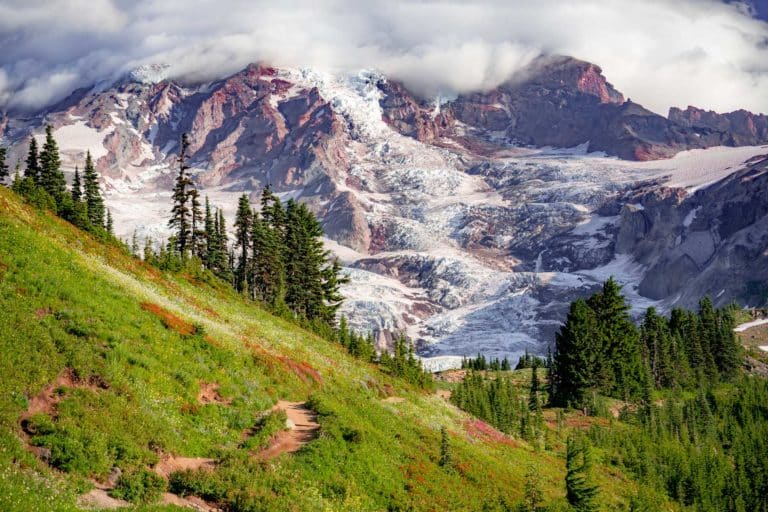
The main scenery-maker here is the Navajo Sandstone, the same formation that builds the walls of Zion Canyon. It is Lower Jurassic in age, roughly 190 million years old, and it started as sand dunes in a vast desert that covered this part of the continent. The cross-bedded layers you see in the cliff faces are the frozen surfaces of those ancient dunes. The red and orange coloring comes from hematite, iron oxide that acts as a cement between the sand grains.
What makes Kolob geologically distinct from the main canyon is the Hurricane Fault, a major fracture in the earth’s crust that runs along the western edge of the Colorado Plateau. The fault has lifted the Kolob side up relative to the lowlands to the west, which is why you see these enormous cliff faces exposed right off the interstate. It is an enormous natural cutaway of the Markagunt Plateau, and the finger canyons display both the oldest and youngest rocks in all of Zion, along with the park’s tallest peak, 8,926-foot Horse Ranch Mountain.
I am a photographer, not a geologist. But understanding the geology makes the landscape click. When you see those parallel ridges catching the late afternoon light, you are looking at 190 million years of dune deposits, faulted and uplifted and carved by water into something that barely looks real.
Kolob Canyons Road Scenic Drive
The scenic drive is the backbone of any visit here, and honestly, the road alone is worth the detour off I-15. It climbs roughly 1,000 feet over 5 miles as it winds into the heart of the Kolob Fingers, those enormous red Navajo sandstone ridges that jut out of the earth like the ribs of something ancient and massive.
There are several pullouts along the way, and each one gives you a different angle on the formations. The first few stops look south toward the finger canyons. As you climb higher, the views open up to include the distant Pine Valley Mountains to the west. The colors shift throughout the day, but late afternoon light turns the whole scene into something that barely looks real. The sandstone goes from orange to deep crimson, and if there are clouds catching the light above, forget about it.
The drive takes about 20 minutes if you do not stop. You will stop. Plan for at least an hour, more if you are carrying a camera.
A note on road conditions. Kolob Canyons Road is open for most of the year but closes frequently in winter due to snow and ice. The road has also experienced periodic closures for repairs. In 2023, a section near the Taylor Creek Trailhead collapsed down a steep hillside and required major reconstruction, including excavation to a depth of 8 feet and installation of geo-grid reinforcement. That repair was completed, but the road has seen additional closures since. Always check the NPS conditions page or call the Kolob Canyons Visitor Center before making the drive, especially between November and March.
The Hikes
Kolob Canyons has four primary trails. Two are short and accessible. Two are long backcountry routes that reward serious effort. Here is what to expect from each one.
Timber Creek Overlook Trail
Distance 1 mile round trip
Elevation Gain 100 feet
Difficulty Easy
This short trail starts at the end of Kolob Canyons Road and climbs to a panoramic viewpoint overlooking the Kolob Fingers, the Timber Creek drainage, and the Pine Valley Mountains. On a clear day, you can see all the way to the Markagunt Plateau. The whole thing takes about 20 minutes, and the view-to-effort ratio is one of the best in the entire park.
If you only have time for one thing in Kolob Canyons, do this. There is a small bench at the top if you want to sit and take it in. I have spent more time on that bench than I probably should.
The trail follows a small ridge with open exposure, so bring sunscreen and water even though the distance is short. In summer, morning or late afternoon is the better call. Midday sun flattens everything up here.
Taylor Creek Middle Fork Trail
Distance 5 miles round trip
Elevation Gain 450 feet
Difficulty Easy to moderate
This is the signature hike in Kolob Canyons, and for good reason. The trail follows the Middle Fork of Taylor Creek through a narrow canyon, crossing the creek multiple times along the way. Expect wet feet, especially in spring when snowmelt keeps the water running. The NPS last assessed water conditions in April 2025 and noted boulders creating obstructions and seasonal water level changes at the crossings. Bring shoes that can handle getting wet or carry a pair of water sandals.
Along the trail, you pass two historic homesteader cabins from the early 1900s, Larsen Cabin and Fife Cabin. Both are still standing and worth a look. The trail ends at the Double Arch Alcove, a massive concave overhang carved into the sandstone by centuries of water seepage. The alcove is not a true arch, but it is enormous, and the acoustics inside are genuinely surreal. Clap once and the sound bounces around above you for what feels like a full second.
I have done this trail in every season. Fall is the best, when the cottonwoods along the creek turn gold against the red canyon walls. That color contrast is some of the best autumn scenery in southern Utah. Spring is a close second, with wildflowers along the lower stretches and strong water flow through the creek crossings. Summer works if you start early, but the canyon holds heat in the afternoon. Winter can be beautiful with snow on the red rock, but the trail gets icy and the creek crossings are genuinely cold.
Plan for 2 to 3 hours at a comfortable pace. The trail is family-friendly, though younger kids will need help at some of the creek crossings when the water is up.
La Verkin Creek Trail to Kolob Arch
Distance 14 miles round trip
Elevation Gain 1,950 feet
Difficulty Strenuous (length and cumulative elevation)
This is the big one. Kolob Arch spans approximately 287 feet, making it one of the largest freestanding natural arches on Earth. Getting to it requires a 7-mile one-way hike along La Verkin Creek, which most folks do as a long day hike or an overnight backpacking trip with a permit.
The trail begins at Lee Pass and descends into the canyon with stunning views of the Kolob Fingers as it crosses Timber Creek. The first and last miles have minimal shade and the most elevation change. The majority of the 1,950 feet of cumulative gain hits you on the final 2 to 3 miles as you climb from the creek back up to the trailhead. In between, much of the route follows La Verkin Creek through a shaded canyon, and the walking is pleasant if long.
Bring more water than you think you need. In summer, I would carry at least 3 liters per person. A water filter is smart insurance since you are walking along a creek for most of the route.
The arch comes into view from a spur trail near the turnaround point. You cannot get directly underneath it, but the viewpoint gives you a clear look at the span. It is genuinely massive, and on a weekday, there is a reasonable chance you will have the viewpoint to yourself. Try doing that at Landscape Arch in Arches.
Spring and fall are the best seasons for this hike. Summer heat is punishing on the exposed sections, and the 14-mile round trip is a long day even without temperatures in the 90s. The trail is accessible year-round in theory, but winter conditions can make the creek crossings and shaded sections dangerously icy.
Hop Valley Trail
Distance 13.4 miles one way (to Zion Canyon via connector trails)
Elevation Gain Variable
Difficulty Strenuous
Hop Valley is a backcountry connector trail that links the Kolob Canyons area to the main Zion Canyon via the Wildcat Canyon Trail and eventually the West Rim Trail. This is serious backcountry hiking that requires a permit, solid navigation skills, and multi-day planning. It is not a casual day hike.
That said, for experienced backpackers, the Hop Valley to West Rim route is one of the best through-hikes in the park system. You start in the quiet Kolob section and end up descending into Zion Canyon on the West Rim, which means you go from near-solitude to the full spectacle of the main canyon. It is a legitimate wilderness experience that very few Zion visitors ever attempt.
For a full breakdown of trails in the park, including difficulty ratings and our honest picks, check out our guide to 16 amazing hikes in Zion National Park.
When to Visit Kolob Canyons
Spring (April through early June) and fall (September through November) are the sweet spots. Temperatures are comfortable for hiking, the light is excellent for photography, and you will have fewer folks around than during peak summer, although Kolob never really gets “crowded” in the way Zion Canyon does.
Summer works, but be prepared for heat. Daytime highs can push past 100 degrees at the lower elevations, and the Taylor Creek Trail offers limited shade for much of its length. Start early or go late. The upside of a summer visit is that Kolob Canyons is dramatically less busy than the main canyon, even during the park’s busiest months. While folks are standing in a 90-minute shuttle line in Springdale, you could be sitting at the Timber Creek Overlook with nobody else in sight.
Fall Colors in Kolob
If I had to pick one time of year for Kolob Canyons, it would be late September through mid-October. The cottonwoods along Taylor Creek turn gold, the bigtooth maples on the higher slopes go orange and crimson, and all of it pops against the red Navajo sandstone like someone designed it on purpose. The color typically starts at higher elevations in the last week of September and works its way down over about two weeks. By mid-October, the Taylor Creek canyon floor is at peak color in most years.
Average highs in October sit around the mid-60s, which is perfect hiking weather. The light angle is lower and warmer than summer, the air is clearer, and the combination of fall foliage with crimson sandstone is some of the best autumn scenery in the Southwest.
Winter brings snow to Kolob, and it is beautiful. The red sandstone under a layer of fresh white snow against a blue sky is one of the most striking scenes I have photographed in any national park. The catch is that Kolob Canyons Road can close temporarily during and after storms. The elevation here is higher than the main canyon floor, so snow accumulates faster. When plows are working, pedestrian access is closed too. Check the NPS conditions page before making the drive in winter.
For a deeper look at seasonal conditions across the whole park, we put together a guide on the best time to visit Zion National Park.
Kolob Canyons vs. Zion Canyon
This is not a competition. Both sections of the park are world-class. But the experience of visiting them is fundamentally different, and understanding that difference helps you plan a better trip.
Zion Canyon is a managed experience. You park in Springdale, ride a shuttle, and share the trails with thousands of other folks on any given day. Angels Landing requires a permit lottery. The Narrows trailhead looks like a bus station in summer. The scenery is spectacular, but the logistics are a whole thing.
Kolob Canyons is self-directed. You drive your own car on a 5-mile road. There is no shuttle, no reservation, no timed entry. On an average weekday outside of peak summer, you might share the entire Taylor Creek Trail with a dozen other hikers. The Timber Creek Overlook might have three other cars at the trailhead. The difference in crowd pressure is not marginal. It is orders of magnitude.
The scenery differs too, but in degree rather than kind. Zion Canyon is a deep, narrow slot. You are on the canyon floor looking up at 2,000-foot walls. Kolob is more expansive. You are on the rim looking across at massive ridges and deep finger canyons that stretch toward the horizon. Both are carved from the same Navajo Sandstone. Both are red. Both are enormous. But the perspective is inverted, and that changes the feel of the landscape completely.
My advice. Do both. But if you have only one day and your priority is solitude and scenery over famous trailheads and bragging rights, Kolob might actually be the better call.
Photography in Kolob Canyons
I am going to be direct about this. Kolob Canyons is one of the most photogenic sections of any national park in Utah, and almost nobody photographs it. The compositions here practically build themselves.
Late afternoon is the prime window. The Kolob Fingers face roughly east, which means the last few hours of daylight paint the sandstone in deep reds and oranges as the sun drops behind you. The pullouts along Kolob Canyons Road give you clean sightlines to the finger canyons, and a telephoto lens in the 70-200mm range is ideal for isolating individual formations. Wider angles work well at the Timber Creek Overlook, where the full panorama opens up.
Early morning works too, especially in fall and winter when low-angle light rakes across the canyon walls. But the afternoon glow is what makes this place special.
The Taylor Creek Trail in autumn is a different kind of shot entirely. Golden cottonwood leaves against red canyon walls, with the creek running through the foreground. It is southern Utah fall color at its finest, and you will have the trail mostly to yourself while every photographer in the state is fighting for position at the Watchman in Zion Canyon.
If you catch snow on the red rock, shoot everything. That color combination of white, red, and blue is one of the most striking palettes in nature, and conditions like that do not last long before the snow melts or the road closes.
Practical Information
Entrance Fee $35 per vehicle (7-day pass), $30 per motorcycle, $20 per person on foot or bicycle. Covered by the America the Beautiful Pass. Non-U.S. residents age 16 and older pay an additional $100 per-person surcharge as of January 1, 2026.
Directions Take Exit 40 off I-15. The visitor center is immediately off the exit. From Cedar City, the drive is about 20 minutes south. From St. George, about 40 minutes north. From Springdale and the main Zion Canyon, about 45 minutes via Highway 9 to I-15 north.
Facilities There is a visitor center with restrooms, a small bookstore, and ranger staff at the entrance. Beyond that, facilities are limited. There are no restaurants, gas stations, or developed campgrounds within the Kolob Canyons section. Cedar City is the nearest town for fuel, food, and lodging.
Camping There are no campgrounds in the Kolob Canyons section. Backcountry camping along the La Verkin Creek and Hop Valley trails requires a permit from the Zion Wilderness desk. The nearest developed campgrounds are in or near Cedar City.
Shuttle or Reservation Neither. You drive your own vehicle on Kolob Canyons Road. There is no timed entry system and no shuttle. Just show up.
Time Needed A minimum of 1.5 to 2 hours for the scenic drive and the Timber Creek Overlook Trail. Half a day if you add the Taylor Creek Trail. A full day or overnight for the La Verkin Creek Trail to Kolob Arch.
Cell Service Spotty to nonexistent once you are past the visitor center. Download maps and trail info before you leave the interstate.
Why Kolob Canyons Matters
I have said this before, but it is worth repeating. Kolob Canyons is what Zion Canyon felt like 30 years ago, before 4.5 million annual visitors changed the equation. The sandstone is the same age, the same color, the same impossible scale. The difference is the quiet. You can stand at the Timber Creek Overlook and hear wind moving through the canyon below you. You can hike the Taylor Creek Trail and go an hour without seeing another person.
That will not last forever. As the main canyon continues to hit capacity and reservation systems become the norm, more folks will discover this corner of the park. That is not a bad thing. More people should see this place. But right now, today, you can drive in without a reservation, hike without a crowd, and photograph some of the finest sandstone formations in the American West without competing for a tripod spot.
The exit on I-15 is easy to miss if you are not looking for it. Most folks are not looking for it.
Their loss.
More Zion National Park Guides
Planning a bigger trip to Zion? These guides cover the rest of the park.
- Zion National Park Complete Guide
- 20 Things to Do in Zion National Park
- 16 Amazing Hikes in Zion National Park
- Best Time to Visit Zion National Park
- 12 Fantastic Facts About Zion National Park
- The Narrows Hike in Zion
- Lava Point Overlook in Zion
- Utah National Parks Guide
What to Bring to Zion
Gear we recommend for Zion. Affiliate links support our work at no cost to you.
Affiliate disclosure: Some links on this page earn us a small commission at no extra cost to you. We only recommend gear we actually use.
More Than Just Parks Film Watch our 8K film of Zion We spent weeks in Zion, one of our favorite public lands destinations, capturing it the way it deserves. Take a few minutes and see it for yourself.