
Peak color lands around Oct 4 in most of Colorado, but it moves 52 days across the state. Here’s where, and when, and how sure we are.
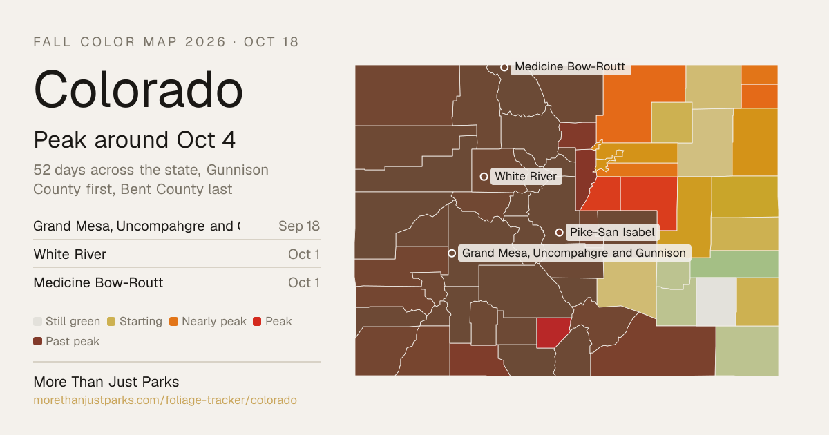
Colorado fall color map, week of Oct 12
When is peak fall color in Colorado in 2026?
Most of Colorado peaks between Sep 26 and Nov 1: the high country first, around Sep 29, and the low ground last, around Oct 30. The first county to peak is Gunnison County, around Sep 18, and the last is Bent County, around Nov 9.
Elevation does most of the work here. Color runs down a mountain at roughly a day per 100 meters, so a ridge and the valley below it can be a week or two apart in the same county. This fall is running 4 days late on September's temperatures, and the dates here already include it.
| Week | Where it peaks | Most of the state |
|---|---|---|
| Sep 14 to Sep 20 | Grand Mesa, Uncompahgre and Gunnison National Forests, Flat Tops Wilderness, West Elk Wilderness and 3 counties | Starting to turn |
| Sep 21 to Sep 27 | Collegiate Peaks Wilderness, Mount Zirkel Wilderness, La Garita Wilderness and 7 counties | Nearly peak |
| Sep 28 to Oct 4 | White River National Forest, Medicine Bow-Routt National Forest, Rio Grande National Forest and 25 counties | Peak color |
| Oct 5 to Oct 11 | Pike-San Isabel National Forests, San Juan National Forest, Lost Creek Wilderness and 5 counties | Peak color |
| Oct 12 to Oct 18 this week | Dominguez/Escalante National Conservation Area, Great Sand Dunes National Park, Baca National Wildlife Refuge and 1 county | Just past peak |
| Oct 19 to Oct 25 | Dinosaur National Monument, Pawnee National Grassland, Black Ridge Canyons Wilderness Area and 7 counties | Fading |
| Oct 26 to Nov 1 | Canyons of the Ancients National Monument, McInnis Canyons National Conservation Area, Colorado National Monument and 10 counties | Leaves down |
| Nov 2 to Nov 8 | Comanche National Grassland, Bent's Old Fort National Historic Site and 5 counties | Leaves down |
| Nov 9 to Nov 15 | Bent County | Leaves down |
Each date is the middle of the four days we’d aim a trip at, and each place page names them. We publish what the model got wrong, region by region.
20 of 64 counties here are corrected by people who have actually looked at the trees this season. 103 reports from official state sources have moved those dates off the model and narrowed their windows. Counties with neither keep the model forecast and say so. Which is which is marked in the table below.
Mid-September at 10,000 feet, late September at 8,000 feet, early October in the valleys is how Colorado is usually described.
Colorado’s season, place by place
The 24 places closest to their peak in Colorado, each set on the calendar at its peak and painted by how far along it is today, Oct 18.
First: Indian Peaks Wilderness, Sep 17. Last: Bent's Old Fort National Historic Site, Nov 6.
The dashed rule is today; the solid one is the median of the places on this chart, Oct 21. The date at the top of the page is the median county, which includes the low ground between them.
Where to go in Colorado
The destinations we cover in Colorado, in the order their color arrives. Each carries its own forecast and its own band, because a state isn’t one place.
- Dinosaur National MonumentPeakPeak Oct 20 best Oct 19 to 22
- Black Ridge Canyons Wilderness AreaPeakPeak Oct 20 best Oct 19 to 22
- Pawnee National GrasslandPeakPeak Oct 21 best Oct 20 to 23
- PeakPeak Oct 21 best Oct 20 to 23
- Tabeguache Wilderness AreaPeakPeak Oct 21 best Oct 20 to 23
- Chimney Rock National MonumentPeakPeak Oct 22 best Oct 21 to 24
- Rocky Mountain Arsenal National Wildlife RefugePeakPeak Oct 23 best Oct 22 to 25
- PeakPeak Oct 24 best Oct 23 to 26
- Gunnison Gorge Wilderness AreaPeakPeak Oct 24 best Oct 23 to 26
- Colorado National MonumentPeakPeak Oct 26 best Oct 25 to 28
- Canyons of the Ancients National MonumentPeakPeak Oct 27 best Oct 26 to 29
- McInnis Canyons National Conservation AreaPeakPeak Oct 28 best Oct 27 to 30
- Sand Creek Massacre National Historic SitePeakPeak Oct 28 best Oct 27 to 30
- Hovenweep National MonumentPeakPeak Oct 28 best Oct 27 to 30
- Near peakPeak Oct 17 best Oct 16 to 19
- Browns Park National Wildlife RefugeNear peakPeak Oct 18 best Oct 17 to 20
- Comanche National GrasslandToo earlyPeak Nov 6 best Nov 5 to 8
- Bent's Old Fort National Historic SiteToo earlyPeak Nov 6 best Nov 5 to 8
- Past peakPeak Sep 17 best Sep 16 to 19
- Past peakPeak Sep 18 best Sep 17 to 20
- Past peakPeak Sep 18 best Sep 17 to 20
- Fossil Ridge Recreation Management AreaPast peakPeak Sep 18 best Sep 17 to 20
- Past peakPeak Sep 18 best Sep 17 to 20
- Past peakPeak Sep 18 best Sep 17 to 20
Also forecast in ColoradoArapaho and Roosevelt National ForestsArapaho National Recreation AreaBrowns Canyon National MonumentBuffalo Peaks WildernessCamp Hale - Continental Divide National MonumentCollegiate Peaks WildernessComanche Peak WildernessCurecanti National Recreation AreaDominguez Canyon Wilderness AreaEagles Nest WildernessGreat Sand Dunes National ParkHoly Cross WildernessHunter-Fryingpan WildernessJames Peak WildernessLizard Head WildernessLost Creek WildernessManti-La Sal National ForestMaroon Bells-Snowmass WildernessMedicine Bow-Routt National ForestMolas Pass National Recreation AreaMount Evans WildernessMount Massive WildernessMount Sneffels WildernessPike-San Isabel National ForestsPlatte River WildernessPowderhorn WildernessPtarmigan Peak WildernessRaggeds WildernessRawah WildernessRio Grande National ForestRocky Flats National Wildlife RefugeRocky Mountain National ParkSan Juan National ForestSouth San Juan WildernessSpanish Peaks WildernessUncompahgre WildernessWeminuche WildernessWhite River National Forest
Questions people ask about Colorado fall colors
- When is peak fall color in Colorado?
Most of Colorado peaks between Sep 26 and Nov 1: the high country first, around Sep 29, and the low ground last, around Oct 30. The first county to peak is Gunnison County, around Sep 18, and the last is Bent County, around Nov 9. This fall is running 4 days late on September's temperatures, and the dates here already include it.
- Where is the best fall color in Colorado right now?
As of Oct 18, Dinosaur National Monument, Black Ridge Canyons Wilderness Area, Pawnee National Grassland and five more are at peak, with Rocky Mountain Arsenal National Wildlife Refuge, Gunnison Gorge National Conservation Area and Gunnison Gorge Wilderness Area within a week of it. Colorado National Monument follows around Oct 26.
- How long does peak last in Colorado?
In any one place, about four days at the top, with a week or so either side that's still worth the drive. Across Colorado as a whole, peak moves 52 days from Gunnison County to Bent County, so there's peak color somewhere in the state for about 56 days.
- Is Colorado past peak?
Mostly. As of Oct 18, 41 of Colorado's 64 counties are past peak, 2 are at it and 21 are still ahead. Bent County is the last to peak, around Nov 9.
- How far along is Colorado's fall color today?
On Oct 18, 2 of Colorado's 64 counties (3 percent) are at peak, 20 (31 percent) are turning, 41 (64 percent) are past peak and 1 (2 percent) is still green. The county map above paints each one, and the live map lets you scrub the day.
- When do the leaves change in Colorado?
The first color shows in Gunnison County around Aug 28 and peaks there around Sep 18. Bent County is the last of Colorado's 64 counties, peaking around Nov 9. Most of the state turns through the weeks around Oct 4.
- What's the best time to visit Colorado for fall colors?
The week of Oct 4 catches the most of the state at once, and the four days we'd aim at there are Oct 3 to 6. That's the leaf peeping window for Colorado as a whole. For Gunnison County and the counties around it, aim for the week of Sep 18; for Bent County and its neighbors, the week of Nov 9.
What actually turns
Colorado aspens are the main event, turning entire mountainsides gold and amber while Gambel oaks add russet and orange at lower elevations and cottonwoods line the rivers in yellow.
- Quaking Aspen
- Narrowleaf Cottonwood
- Gambel Oak
- Rocky Mountain Maple
- Alder
Kebler Pass between Crested Butte and Paonia runs through one of the largest aspen groves on Earth, and in late September it is a wall of gold stretching to the horizon.
Worth the drive
Gunnison County contains Crested Butte and Kebler Pass, home to one of the largest aspen groves on Earth. The aspens here grow in massive clonal stands that color entire mountainsides in a single week, and the gold against the dark green of spruce and the gray of the West Elk and Raggeds peaks is as graphic as any fall landscape in America. Time your visit for the last week of September.
San Juan County contains Silverton and the northern end of the Million Dollar Highway, and it sits in the most rugged mountain terrain in Colorado. The aspens here grow on steep slopes above the road between 9,000 and 11,000 feet, and the color against the red and gray rock of the San Juan Mountains is stark and beautiful. Red Mountain Pass is the centerpiece.
Pitkin County is home to Aspen, Colorado, the town that literally took its name from the tree. The Maroon Bells, the most photographed peaks in North America, are reflected in Maroon Lake with aspen groves on the slopes above. Castle Creek Road and the road to Ashcroft are two of the most concentrated aspen drives in the state, and they peak in the last two weeks of September.
Every county, by peak week
Grand observed, Gunnison observed, Lake
Chaffee regional, Clear Creek observed, Conejos observed, Costilla, Custer, Delta regional, Dolores, Fremont, Garfield, Hinsdale, Jackson observed, Mesa observed, Park, Rio Grande, Saguache corrected, San Juan corrected, Summit observed
Eagle observed, El Paso, Gilpin regional, Huerfano observed, La Plata corrected, Larimer observed, Mineral observed, Moffat, Montezuma, Montrose, Ouray, Pitkin observed, Rio Blanco, Routt, San Miguel corrected, Teller observed
Archuleta, Boulder observed, Jefferson corrected, Las Animas
Alamosa, Douglas regional, Elbert
Adams regional, Arapahoe regional, Broomfield regional, Denver regional, Lincoln, Phillips, Sedgwick, Weld corrected, Yuma
Cheyenne, Kit Carson, Logan, Morgan, Prowers, Pueblo, Washington
Baca, Bent, Crowley, Kiowa, Otero
Every date on this site is a forecast: a model corrected by ground reports, carrying a measured error, published in full. Check conditions with the land manager before you travel. Last reviewed September 2026. Open the live map