
Peak color lands around Oct 27 in most of Kansas, but it moves 14 days across the state. Here’s where, and when, and how sure we are.
Kansas fall foliage map, week of Oct 26
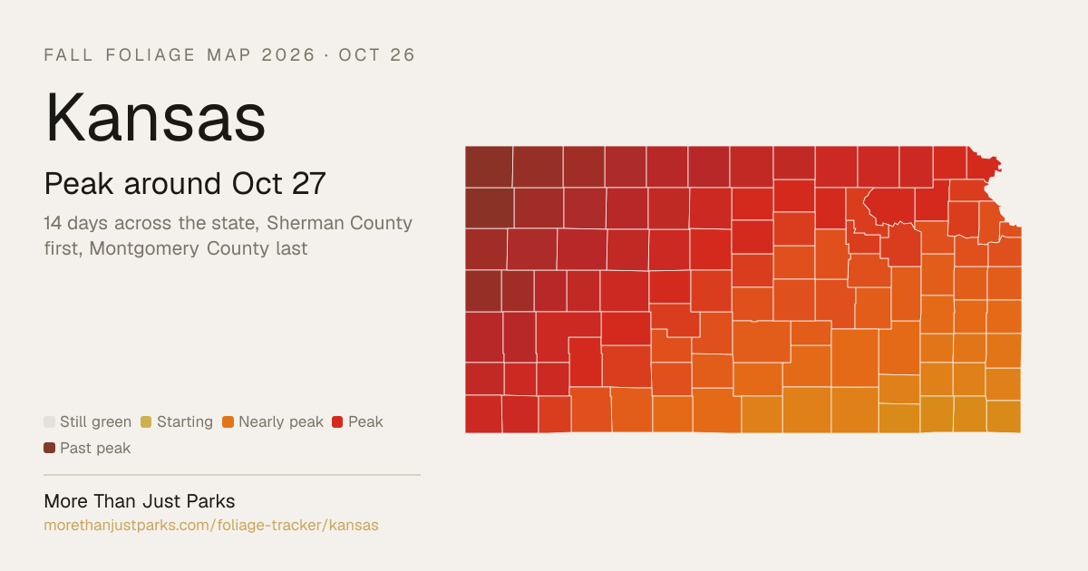
When is peak fall foliage in Kansas in 2026?
Most of Kansas peaks between Oct 22 and Nov 1: the high country first, around Oct 24, and the low ground last, around Oct 29. The first county to peak is Sherman County, around Oct 19, and the last is Montgomery County, around Nov 2.
Elevation does most of the work here. Color runs down a mountain at roughly a day per 100 meters, so a ridge and the valley below it can be a week or two apart in the same county. This fall is running 6 days late on September's temperatures, and the dates here already include it.
| Week | Where it peaks | Most of the state |
|---|---|---|
| Oct 19 to Oct 25 | Cheyenne County, Sherman County, Greeley County and 32 more | Nearly peak |
| Oct 26 to Nov 1 this week | Cimarron National Grassland, Quivira National Wildlife Refuge, Flint Hills National Wildlife Refuge and 66 counties | Peak color |
| Nov 2 to Nov 8 | Chautauqua County, Cherokee County, Labette County and 1 more | Just past peak |
Each date is the middle of the four days we’d aim a trip at, and each place page names them. We publish what the model got wrong, region by region.
Late October through mid-November is how Kansas is usually described.
Kansas’s season, place by place
Every place we forecast in Kansas, each set on the calendar at its peak and painted by how far along it is today, Oct 26.
First: Cimarron National Grassland, Oct 26. Last: Marais Des Cygnes National Wildlife Refuge, Oct 30.
The dashed rule is today; the solid one is the median of the places on this chart, Oct 28. The date at the top of the page is the median county, which includes the low ground between them.
Where to go in Kansas
The destinations we cover in Kansas, in the order their color arrives. Each carries its own forecast and its own band, because a state isn’t one place.
- Fort Larned National Historic SitePeakPeak Oct 27 best Oct 26 to 29
- Quivira National Wildlife RefugePeakPeak Oct 28 best Oct 27 to 30
- Flint Hills National Wildlife RefugePeakPeak Oct 29 best Oct 28 to 31
- Marais Des Cygnes National Wildlife RefugePeakPeak Oct 30 best Oct 29 to Nov 1
- Cimarron National GrasslandNear peakPeak Oct 26 best Oct 25 to 28
Questions people ask about Kansas fall foliage
- When is peak fall foliage in Kansas?
Most of Kansas peaks between Oct 22 and Nov 1: the high country first, around Oct 24, and the low ground last, around Oct 29. The first county to peak is Sherman County, around Oct 19, and the last is Montgomery County, around Nov 2. This fall is running 6 days late on September's temperatures, and the dates here already include it.
- Where is the best fall foliage in Kansas right now?
As of Oct 26, Fort Larned National Historic Site, Quivira National Wildlife Refuge, Flint Hills National Wildlife Refuge and two more are at peak.
- How long does peak last in Kansas?
In any one place, about four days at the top, with a week or so either side that's still worth the drive. Across Kansas as a whole, peak moves 14 days from Sherman County to Montgomery County, so there's peak color somewhere in the state for about 18 days.
- Is Kansas past peak?
Not yet for most of it. As of Oct 26, 18 of Kansas's 105 counties are past peak, 40 are at it and 47 are still ahead.
- How far along is Kansas's fall foliage today?
On Oct 26, 40 of Kansas's 105 counties (38 percent) are at peak, 47 (45 percent) are turning and 18 (17 percent) are past peak. The county map above paints each one, and the live map lets you scrub the day.
- When do the leaves change in Kansas?
The first color shows in Sherman County around Sep 28 and peaks there around Oct 19. Montgomery County is the last of Kansas's 105 counties, peaking around Nov 2. Most of the state turns through the weeks around Oct 27.
- What's the best time to visit Kansas for fall foliage?
The week of Oct 27 catches the most of the state at once, and the four days we'd aim at there are Oct 26 to 29. That's the leaf peeping window for Kansas as a whole. For Sherman County and the counties around it, aim for the week of Oct 19; for Montgomery County and its neighbors, the week of Nov 2.
What actually turns
The Flint Hills turn amber and bronze as the grasses cure, cottonwoods line the creek bottoms in gold, and the eastern hardwood forests produce scattered oaks in burgundy and rust.
- Cottonwood
- Red Oak
- Hackberry
- Honey Locust
- Bur Oak
The eastern Flint Hills along the Kansas Turnpike south of Emporia are most famous for their tallgrass prairie, but the oak-hickory forests along the Missouri border around Leavenworth produce real color.
Every county, by peak week
Cheyenne, Greeley, Rawlins, Sherman
Atchison, Barton, Brown, Clay, Cloud, Decatur, Doniphan, Ellis, Ellsworth, Finney, Ford, Geary, Gove, Graham, Grant, Gray, Hamilton, Haskell, Hodgeman, Jackson, Jefferson, Jewell, Kearny, Lane, Lincoln, Logan, Marshall, Mitchell, Morton, Nemaha, Ness, Norton, Osborne, Ottawa, Pawnee, Phillips, Pottawatomie, Republic, Riley, Rooks, Rush, Russell, Scott, Seward, Sheridan, Smith, Stanton, Stevens, Thomas, Trego, Wabaunsee, Wallace, Washington, Wichita
Allen, Anderson, Barber, Bourbon, Butler, Chase, Chautauqua, Cherokee, Clark, Coffey, Comanche, Cowley, Crawford, Dickinson, Douglas, Edwards, Elk, Franklin, Greenwood, Harper, Harvey, Johnson, Kingman, Kiowa, Labette, Leavenworth, Linn, Lyon, Marion, McPherson, Meade, Miami, Montgomery, Morris, Neosho, Osage, Pratt, Reno, Rice, Saline, Sedgwick, Shawnee, Stafford, Sumner, Wilson, Woodson, Wyandotte
Every date on this site is a forecast: a model corrected by ground reports, carrying a measured error, published in full. Check conditions with the land manager before you travel. Last reviewed September 2026. Open the live map