More Than Just ParksFoliage TrackerPowered byPublic Lands Intelligence

Forecast issued 25 Sep, 5:21pm ET

Back to the map

National Forest·Colorado·2,965,451 acres

Grand Mesa, Uncompahgre and Gunnison National Forests

Forecast issued 25 Sep, 5:21pm ET

Peak color4 OctAim for 3 to 6 Oct
In the forest today, Sep 25Starting to turn
SepOctNov

Higher ground turns first, so the slopes above the road lead the valley by a few days.

17 reports came in from Gunnison County this week, 5 of them past peak and 4 of them at peak. Our date held. See the county on the map.

Conejos County, peak Sep 29Summit County, peak Sep 26Jackson County, peak Sep 25Archuleta County, peak Oct 7Coconino County, peak Oct 8Washington County, peak Nov 1San Juan County, peak Oct 2Garfield County, peak Sep 28Rio Grande County, peak Sep 28Morgan County, peak Oct 29Elbert County, peak Oct 18Montrose County, peak Oct 4Otero County, peak Nov 5Teller County, peak Sep 29Pueblo County, peak Oct 31Alamosa County, peak Oct 14Montezuma County, peak Oct 4Union County, peak Oct 26Daggett County, peak Sep 22Arapahoe County, peak Oct 20Mineral County, peak Sep 27Rio Arriba County, peak Oct 6Dolores County, peak Sep 29Davis County, peak Oct 4Piute County, peak Sep 26Utah County, peak Sep 30Sanpete County, peak Sep 22Navajo County, peak Oct 20Taos County, peak Oct 4Wayne County, peak Sep 29Emery County, peak Sep 26San Juan County, peak Oct 9Garfield County, peak Sep 27Jefferson County, peak Oct 3Delta County, peak Sep 30Grand County, peak Sep 20Saguache County, peak Sep 25Summit County, peak Sep 21Gunnison County, peak Sep 28Costilla County, peak Sep 28Weld County, peak Oct 25Las Animas County, peak Oct 7Routt County, peak Sep 29Uintah County, peak Sep 26Douglas County, peak Oct 16Rio Blanco County, peak Sep 30Broomfield County, peak Oct 21Denver County, peak Oct 22Boulder County, peak Sep 24Larimer County, peak Sep 23Crowley County, peak Nov 5Custer County, peak Sep 26El Paso County, peak Sep 30Gilpin County, peak Sep 25Huerfano County, peak Sep 30Duchesne County, peak Sep 21Juab County, peak Sep 22Ouray County, peak Sep 30Sevier County, peak Sep 30Moffat County, peak Oct 2Pitkin County, peak Sep 28San Juan County, peak Sep 28La Plata County, peak Oct 1Hinsdale County, peak Sep 25Carbon County, peak Sep 28Grand County, peak Sep 30San Miguel County, peak Sep 29Clear Creek County, peak Sep 21Kiowa County, peak Nov 7Colfax County, peak Oct 4Park County, peak Sep 23Lake County, peak Sep 18Lincoln County, peak Oct 26Adams County, peak Oct 24Eagle County, peak Sep 25Wasatch County, peak Sep 24Logan County, peak Oct 31Chaffee County, peak Sep 27Apache County, peak Oct 12Fremont County, peak Sep 28Mesa County, peak Sep 25Salt Lake County, peak Oct 4Bent County, peak Nov 8Kane County, peak Oct 2I-76I-70I-25US 36PaoniaGrand JunctionColorado SpringsDeltaHighlands RanchPuebloDurangoGlenwood SpringsUncompahgre Wildernesspeak 20 SepMaroon Bells-Snowmass Wildernesspeak 28 SepCollegiate Peaks Wildernesspeak 22 SepGrand Mesa, Uncompahgre and Gunnison
Conejos County, peak Sep 29Summit County, peak Sep 26Jackson County, peak Sep 25Archuleta County, peak Oct 7San Juan County, peak Oct 2Garfield County, peak Sep 28Rio Grande County, peak Sep 28Montrose County, peak Oct 4Teller County, peak Sep 29Pueblo County, peak Oct 31Alamosa County, peak Oct 14Montezuma County, peak Oct 4Daggett County, peak Sep 22Arapahoe County, peak Oct 20Mineral County, peak Sep 27Rio Arriba County, peak Oct 6Dolores County, peak Sep 29Navajo County, peak Oct 20Taos County, peak Oct 4Wayne County, peak Sep 29Emery County, peak Sep 26San Juan County, peak Oct 9Garfield County, peak Sep 27Jefferson County, peak Oct 3Delta County, peak Sep 30Grand County, peak Sep 20Saguache County, peak Sep 25Summit County, peak Sep 21Gunnison County, peak Sep 28Costilla County, peak Sep 28Weld County, peak Oct 25Las Animas County, peak Oct 7Routt County, peak Sep 29Uintah County, peak Sep 26Douglas County, peak Oct 16Rio Blanco County, peak Sep 30Broomfield County, peak Oct 21Denver County, peak Oct 22Boulder County, peak Sep 24Larimer County, peak Sep 23Custer County, peak Sep 26El Paso County, peak Sep 30Gilpin County, peak Sep 25Huerfano County, peak Sep 30Duchesne County, peak Sep 21Ouray County, peak Sep 30Moffat County, peak Oct 2Pitkin County, peak Sep 28San Juan County, peak Sep 28La Plata County, peak Oct 1Hinsdale County, peak Sep 25Carbon County, peak Sep 28Grand County, peak Sep 30San Miguel County, peak Sep 29Clear Creek County, peak Sep 21Colfax County, peak Oct 4Park County, peak Sep 23Lake County, peak Sep 18Adams County, peak Oct 24Eagle County, peak Sep 25Chaffee County, peak Sep 27Apache County, peak Oct 12Fremont County, peak Sep 28Mesa County, peak Sep 25I-70US 34US 6US 24PaoniaDeltaAspenRifleCarbondaleDurangoTellurideGypsumGrand Mesa, Uncompahgre and Gunnison
Still greenStartingNearly peakPeakPast peakNo fall canopy we forecastInside the line, each band of elevation is painted on its own date.
Around Grand Mesa, Uncompahgre and Gunnison National Forests Gunnison County holds most of the forest and is nearly peak today. That’s the county as a whole, which peaks 6 days earlier than the forest’s own stands: the forest is starting to turn. San Miguel County, to the southwest, is 1 day behind. Ouray County, to the southwest, is 2 days behind.
By elevation The forest runs from about 6,768 to 12,141 feet. That’s 19 days of season between the top and the bottom: the high stands peak around Sep 23, the low ground holds until about Oct 12, and the color comes downhill in between. The date at the top of this page is the 8,000 to 10,000 foot band.
  1. 12,000–14,000 ftPeak colorpeak Sep 237%
  2. 10,000–12,000 ftJust past peakpeak Sep 1835%
  3. 8,000–10,000 ftNearly peakpeak Sep 2940%
  4. 6,000–8,000 ftStarting to turnpeak Oct 1218%

Height off 3DEP inside the forest’s own boundary; each band carries the date our model gives that elevation, corrections and all. The percentage is how much of the forest stands in it.
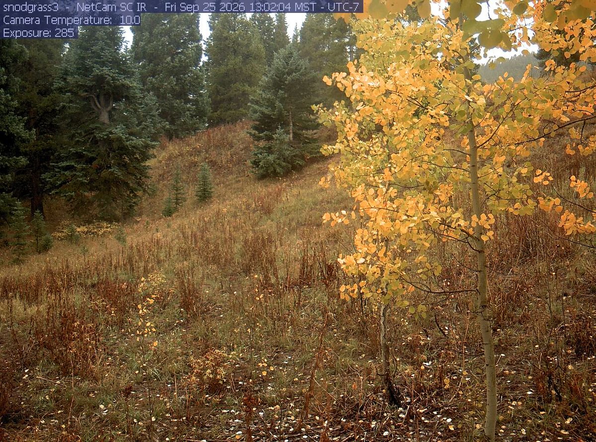
Today from the snodgrass3 camera, 19 km from Grand Mesa, Uncompahgre and Gunnison National Forests
See it now PhenoCam Network, SNOD-MA camera, 19 km away, captured Sep 25.

That’s 3 days later than our model alone would say. This September has been running warm, which shifts peak color.

Plan this trip

If you can only come on certain days

Set the days you can be here. Everything under them answers for those days, not for peak.

Saturday 3 October to Sunday 4 October

You’ll find it fading up high, nearly peak lower down.

Up at 10,000 feet the stands peak around Sep 18; down at 8,000 feet they hold on until about Oct 12. Pick your elevation for the day you come.

  • 10,000–12,000 ftFadingpeak Sep 18
  • 8,000–10,000 ftJust past peakpeak Sep 29
  • 6,000–8,000 ftNearly peakpeak Oct 12
Where to drive
Kebler Pass Road (County Road 12), about 27 miles · Owl Creek Pass, about 27 miles · McClure Pass (CO 133), about 39 miles
What turns
quaking aspen, narrowleaf cottonwood, Gambel oak, willow, bigtooth maple

What turns, and when

Also named across Colorado, outside what the canopy read measures here: Rocky Mountain Maple, Alder.

Colorado aspens are the main event, turning entire mountainsides gold and amber while Gambel oaks add russet and orange at lower elevations and cottonwoods line the rivers in yellow.

This forecast is built from the species that stand here, their elevation and this September’s weather, and corrected in season by cameras, foresters and our own crew. Out here we score it against NASA's satellite record of when the canopy shuts down, read inside each unit’s own boundary: two dates in three land within 12 days of it. How this map is made

All of Colorado