More Than Just ParksFoliage TrackerPowered byPublic Lands Intelligence

Forecast issued 25 Sep, 5:21pm ET

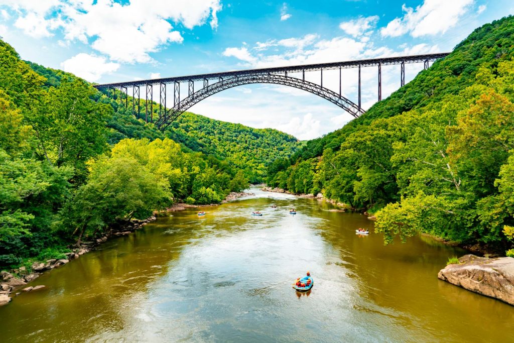
The gorge bridge over the river.

Back to the map

National Park·West Virginia·52,890 acres

New River Gorge National Park and Preserve

Forecast issued 25 Sep, 5:21pm ET

Photograph: More Than Just Parks

Peak color22 OctAim for 21 to 24 Oct
In the park today, Sep 25Still green
SepOctNov

Higher ground turns first, so the slopes above the road lead the valley by a few days.

No new reports from the ground here this week.

Scott County, peak Oct 27Botetourt County, peak Oct 27Pocahontas County, peak Oct 15City of Radford, peak Oct 26McDowell County, peak Oct 25City of Salem, peak Oct 27Gilmer County, peak Oct 24Webster County, peak Oct 19Pulaski County, peak Oct 24Randolph County, peak Oct 15Meigs County, peak Oct 25Gallia County, peak Oct 26Greenbrier County, peak Oct 19Henry County, peak Oct 31Highland County, peak Oct 17Montgomery County, peak Oct 25Mercer County, peak Oct 22Barbour County, peak Oct 20Martin County, peak Oct 28Summers County, peak Oct 23Pike County, peak Oct 29Tazewell County, peak Oct 22Washington County, peak Oct 26Cabell County, peak Oct 27Wise County, peak Oct 26Clay County, peak Oct 25Wirt County, peak Oct 25Bland County, peak Oct 22Calhoun County, peak Oct 25Buchanan County, peak Oct 25Dickenson County, peak Oct 27Logan County, peak Oct 27Pendleton County, peak Oct 17Floyd County, peak Oct 23City of Roanoke, peak Oct 28Alleghany County, peak Oct 22Giles County, peak Oct 21Franklin County, peak Oct 28Bath County, peak Oct 21Boone County, peak Oct 26Fayette County, peak Oct 21Kanawha County, peak Oct 26Roane County, peak Oct 25Pittsylvania County, peak Oct 31Lewis County, peak Oct 23Craig County, peak Oct 23Mingo County, peak Oct 27Rockbridge County, peak Oct 24Lawrence County, peak Oct 26Nicholas County, peak Oct 21Putnam County, peak Oct 26Wyoming County, peak Oct 24Carroll County, peak Oct 24Wythe County, peak Oct 23Patrick County, peak Oct 28Raleigh County, peak Oct 22Upshur County, peak Oct 20Wayne County, peak Oct 27Smyth County, peak Oct 23Lincoln County, peak Oct 27Russell County, peak Oct 25Braxton County, peak Oct 24Bedford County, peak Oct 29Roanoke County, peak Oct 24City of Covington, peak Oct 24Monroe County, peak Oct 22Jackson County, peak Oct 25Mason County, peak Oct 26I-79I-64I-77I-19Oak HillBeckleyFayettevilleShady SpringBradleyDanielsStanafordHintonMountain Lake Wildernesspeak 21 OctCranberry Wildernesspeak 14 OctGeorge Washington and Jeffersonpeak 22 OctMonongahelapeak 15 OctNew River Gorge
Botetourt County, peak Oct 27Pocahontas County, peak Oct 15City of Radford, peak Oct 26McDowell County, peak Oct 25City of Salem, peak Oct 27Gilmer County, peak Oct 24Webster County, peak Oct 19Pulaski County, peak Oct 24Randolph County, peak Oct 15Meigs County, peak Oct 25Greenbrier County, peak Oct 19Henry County, peak Oct 31Montgomery County, peak Oct 25Mercer County, peak Oct 22Barbour County, peak Oct 20Summers County, peak Oct 23Pike County, peak Oct 29Tazewell County, peak Oct 22Washington County, peak Oct 26Clay County, peak Oct 25Wirt County, peak Oct 25Bland County, peak Oct 22Calhoun County, peak Oct 25Buchanan County, peak Oct 25Logan County, peak Oct 27Floyd County, peak Oct 23City of Roanoke, peak Oct 28Alleghany County, peak Oct 22Giles County, peak Oct 21Franklin County, peak Oct 28Bath County, peak Oct 21Boone County, peak Oct 26Fayette County, peak Oct 21Kanawha County, peak Oct 26Roane County, peak Oct 25Lewis County, peak Oct 23Craig County, peak Oct 23Mingo County, peak Oct 27Nicholas County, peak Oct 21Putnam County, peak Oct 26Wyoming County, peak Oct 24Carroll County, peak Oct 24Wythe County, peak Oct 23Patrick County, peak Oct 28Raleigh County, peak Oct 22Upshur County, peak Oct 20Smyth County, peak Oct 23Lincoln County, peak Oct 27Russell County, peak Oct 25Braxton County, peak Oct 24Roanoke County, peak Oct 24City of Covington, peak Oct 24Monroe County, peak Oct 22Jackson County, peak Oct 25Mason County, peak Oct 26I-64I-77I-19US 19Oak HillFayettevilleShady SpringDanielsRainelleAnstedSummersvilleAldersonNew River Gorge
Still greenStartingNearly peakPeakPast peakNo fall canopy we forecastInside the line, each band of elevation is painted on its own date.
Around New River Gorge National Park and Preserve Fayette County holds most of the park and is still green today. Raleigh County, to the southwest, is 1 day behind. Summers County, to the south, is 2 days behind.
By elevation The park runs from about 1,239 to 2,814 feet. That’s 7 days of season between the top and the bottom: the high stands peak around Oct 19, the low ground holds until about Oct 26, and the color comes downhill in between. The date at the top of this page is the 1,500 to 2,000 foot band.
  1. 2,500–3,000 ftStill greenpeak Oct 1926%
  2. 2,000–2,500 ftStill greenpeak Oct 2128%
  3. 1,500–2,000 ftStill greenpeak Oct 2331%
  4. 1,000–1,500 ftStill greenpeak Oct 2615%

Height off 3DEP inside the park’s own boundary; each band carries the date our model gives that elevation, corrections and all. The percentage is how much of the park stands in it.

Today from the summit1 camera, 10 km from New River Gorge National Park and Preserve
See it now PhenoCam Network, Summit Bechtel Reserve camera, 10 km away, captured Sep 25.

That’s 4 days later than our model alone would say. This September has been running warm, which shifts peak color.

Plan this trip

If you can only come on certain days

Set the days you can be here. Everything under them answers for those days, not for peak.

Wednesday 21 October to Thursday 22 October

You’ll find it just past peak up high, nearly peak lower down.

Up at 2,500 feet the stands peak around Oct 19; down at 1,500 feet they hold on until about Oct 26. Pick your elevation for the day you come.

  • 2,500–3,000 ftJust past peakpeak Oct 19
  • 2,000–2,500 ftPeak colorpeak Oct 21
  • 1,500–2,000 ftPeak colorpeak Oct 23
  • 1,000–1,500 ftNearly peakpeak Oct 26
Where to drive
Highland Scenic Highway (Route 150), about 58 miles · Route 39 (Goshen Pass), about 85 miles · Hocking Hills Scenic Byway (Route 374), about 135 miles
What turns
white oak, northern red oak, red maple, shagbark hickory, blackgum

What turns, and when

Also named across West Virginia, outside what the canopy read measures here: Sugar Maple, American Beech.

West Virginia is almost entirely forested, and when the sugar maples, oaks, and tulip poplars turn, the entire state becomes a continuous canopy of orange, gold, burgundy, and bronze.

This forecast is built from the species that stand here, their elevation and this September’s weather, and corrected in season by cameras, foresters and our own crew. We score it here against 16 long-running forest cameras: two dates in three land within 7 days of the camera’s own peak. How this map is made