More Than Just ParksFoliage TrackerPowered byPublic Lands Intelligence

Forecast issued 25 Sep, 3:53pm ET

Back to the map

Wilderness Area·North Carolina, Tennessee·19,247 acres

Joyce Kilmer-Slickrock Wilderness

Forecast issued 25 Sep, 3:53pm ET

Peak color23 OctAim for 22 to 25 Oct
In the wilderness today, Sep 25Still green
SepOctNov

Higher ground turns first, so the slopes above the road lead the valley by a few days.

No new reports from the ground here this week.

Scott County, peak Oct 30Sequatchie County, peak Nov 3Bartow County, peak Nov 7Bledsoe County, peak Nov 2Greenville County, peak Nov 3Washington County, peak Oct 28Fannin County, peak Oct 31Hancock County, peak Oct 29Transylvania County, peak Oct 25White County, peak Nov 2Floyd County, peak Nov 7Murray County, peak Nov 3Loudon County, peak Nov 3Walker County, peak Nov 5DeKalb County, peak Nov 6Anderson County, peak Nov 6Cherokee County, peak Nov 8Greenwood County, peak Nov 8Polk County, peak Nov 1Mitchell County, peak Oct 22Meigs County, peak Nov 5Cocke County, peak Oct 29Haywood County, peak Oct 19Grainger County, peak Oct 30Hawkins County, peak Oct 29Sevier County, peak Oct 28Polk County, peak Nov 2Warren County, peak Nov 4Pickens County, peak Nov 3Anderson County, peak Oct 31Clay County, peak Nov 3Greene County, peak Oct 30Fentress County, peak Oct 31Abbeville County, peak Nov 8Overton County, peak Nov 2Blount County, peak Nov 1Cherokee County, peak Nov 6Gilmer County, peak Nov 2Campbell County, peak Oct 29Hart County, peak Nov 7Yancey County, peak Oct 23Pickens County, peak Nov 5Jefferson County, peak Oct 31Swain County, peak Oct 24DeKalb County, peak Nov 4Laurens County, peak Nov 7White County, peak Nov 3Whitfield County, peak Nov 5Carter County, peak Oct 24Bradley County, peak Nov 4Macon County, peak Oct 25Clay County, peak Oct 27Oconee County, peak Nov 4Dade County, peak Nov 5Pickett County, peak Nov 2Graham County, peak Oct 25Cherokee County, peak Oct 30Putnam County, peak Nov 2Jackson County, peak Oct 22Union County, peak Oct 31Union County, peak Oct 29Dawson County, peak Nov 4Franklin County, peak Nov 7Buncombe County, peak Oct 25Hall County, peak Nov 6Marion County, peak Nov 4Henderson County, peak Oct 27Cumberland County, peak Oct 31Lumpkin County, peak Nov 2Towns County, peak Oct 28Gordon County, peak Nov 7Roane County, peak Nov 3Rabun County, peak Oct 29Grundy County, peak Nov 3Habersham County, peak Nov 3McMinn County, peak Nov 3Madison County, peak Oct 25Hamblen County, peak Oct 31Jackson County, peak Nov 3Catoosa County, peak Nov 5Chattooga County, peak Nov 7Monroe County, peak Oct 31Unicoi County, peak Oct 25Jackson County, peak Nov 6Stephens County, peak Nov 5Banks County, peak Nov 6Hamilton County, peak Nov 4Morgan County, peak Oct 31Claiborne County, peak Oct 30Sullivan County, peak Oct 28Knox County, peak Nov 2Van Buren County, peak Nov 2Rhea County, peak Nov 2I-40I-75I-140US 19AndrewsVonoreMaryvilleAthensTellico VillageLenoir CityMadisonvilleSeviervilleCitico Creek Wildernesspeak 25 OctNantahalapeak 27 OctGreat Smoky Mountainspeak 22 OctSouthern Nantahala Wildernesspeak 22 OctCherokeepeak 26 OctJoyce Kilmer-Slickrock Wilderness
Scott County, peak Oct 30Bartow County, peak Nov 7Bledsoe County, peak Nov 2Fannin County, peak Oct 31Hancock County, peak Oct 29Transylvania County, peak Oct 25White County, peak Nov 2Floyd County, peak Nov 7Murray County, peak Nov 3Loudon County, peak Nov 3Walker County, peak Nov 5Anderson County, peak Nov 6Meigs County, peak Nov 5Cocke County, peak Oct 29Haywood County, peak Oct 19Grainger County, peak Oct 30Hawkins County, peak Oct 29Sevier County, peak Oct 28Polk County, peak Nov 2Pickens County, peak Nov 3Anderson County, peak Oct 31Greene County, peak Oct 30Fentress County, peak Oct 31Overton County, peak Nov 2Blount County, peak Nov 1Cherokee County, peak Nov 6Gilmer County, peak Nov 2Campbell County, peak Oct 29Hart County, peak Nov 7Pickens County, peak Nov 5Jefferson County, peak Oct 31Swain County, peak Oct 24Whitfield County, peak Nov 5Bradley County, peak Nov 4Macon County, peak Oct 25Clay County, peak Oct 27Oconee County, peak Nov 4Pickett County, peak Nov 2Graham County, peak Oct 25Cherokee County, peak Oct 30Putnam County, peak Nov 2Jackson County, peak Oct 22Union County, peak Oct 31Union County, peak Oct 29Dawson County, peak Nov 4Franklin County, peak Nov 7Buncombe County, peak Oct 25Hall County, peak Nov 6Cumberland County, peak Oct 31Lumpkin County, peak Nov 2Towns County, peak Oct 28Gordon County, peak Nov 7Roane County, peak Nov 3Rabun County, peak Oct 29Habersham County, peak Nov 3McMinn County, peak Nov 3Madison County, peak Oct 25Hamblen County, peak Oct 31Catoosa County, peak Nov 5Chattooga County, peak Nov 7Monroe County, peak Oct 31Stephens County, peak Nov 5Banks County, peak Nov 6Hamilton County, peak Nov 4Morgan County, peak Oct 31Claiborne County, peak Oct 30Knox County, peak Nov 2Rhea County, peak Nov 2I-40I-75I-140US 19AndrewsVonoreMaryvilleTellico VillageMadisonvilleLenoir CityAthensLoudonCitico Creek Wildernesspeak 25 OctNantahalapeak 27 OctGreat Smoky Mountainspeak 22 OctSouthern Nantahala Wildernesspeak 22 OctCherokeepeak 26 OctJoyce Kilmer-Slickrock Wilderness
Still greenStartingNearly peakPeakPast peakNo fall canopy we forecastInside the line, each band of elevation is painted on its own date.
Around Joyce Kilmer-Slickrock Wilderness Graham County holds most of the wilderness and is still green today. Monroe County, to the west, is 6 days behind.
By elevation The wilderness runs from about 1,465 to 4,698 feet. That’s 13 days of season between the top and the bottom: the high stands peak around Oct 17, the low ground holds until about Oct 30, and the color comes downhill in between. The date at the top of this page is the 3,000 to 4,000 foot band.
  1. 4,000–5,000 ftStill greenpeak Oct 1718%
  2. 3,000–4,000 ftStill greenpeak Oct 2228%
  3. 2,000–3,000 ftStill greenpeak Oct 2633%
  4. 1,000–2,000 ftStill greenpeak Oct 3021%

Height off 3DEP inside the wilderness’s own boundary; each band carries the date our model gives that elevation, corrections and all. The percentage is how much of the wilderness stands in it.
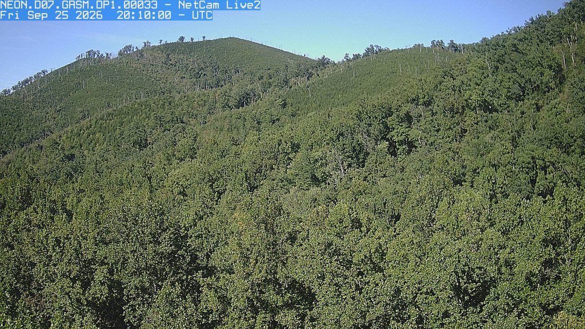
The latest daylight frame from the NEON.D07.GRSM.DP1.00033 camera, 10 km from Joyce Kilmer-Slickrock Wilderness
Latest daylight frame PhenoCam Network, Great Smoky Mountains National Park camera, 10 km away, captured Sep 24.

That’s 4 days later than our model alone would say. This September has been running warm, which shifts peak color.

Plan this trip

If you can only come on certain days

Set the days you can be here. Everything under them answers for those days, not for peak.

Thursday 22 October to Friday 23 October

You’ll find it just past peak up high, nearly peak lower down.

Up at 4,000 feet the stands peak around Oct 17; down at 2,000 feet they hold on until about Oct 30. Pick your elevation for the day you come.

  • 4,000–5,000 ftJust past peakpeak Oct 17
  • 3,000–4,000 ftPeak colorpeak Oct 22
  • 2,000–3,000 ftNearly peakpeak Oct 26
  • 1,000–2,000 ftNearly peakpeak Oct 30
Where to drive
Cherohala Skyway, about 6 miles · Newfound Gap Road, about 34 miles · Blue Ridge Parkway (NC Section), about 103 miles
What turns
northern red oak, red maple, white oak, shagbark hickory, sugar maple

What turns, and when

Also named across North Carolina, outside what the canopy read measures here: Sourwood.

Sourwoods turn deep crimson before anything else, tulip poplars go clear gold, hickories fade to bronze, and the layered ridgelines of the Blue Ridge create that famous smoky depth of warm color.

This forecast is built from the species that stand here, their elevation and this September’s weather, and corrected in season by cameras, foresters and our own crew. We score it here against 16 long-running forest cameras: two dates in three land within 7 days of the camera’s own peak. How this map is made