 MORE THAN JUST PARKS
PART I · WHAT IS PROPOSED CHAPTER 3 What it is for
The road exists to reach four deposits, none of which is a mine. Along the corridor it would open, the State of Alaska carries 5,122 active mining claims on 649,057 acres, two thirds of them staked after the road was applied for, and 504 of them staked in the five weeks after the President revived the permits.
What this chapter finds
Every federal analysis of the road models the same future: four mines in the Ambler Mining District, feeding trucks onto 211 miles of gravel. The traffic forecast of up to 168 trucks a day assumes "full operation of four mines." The state revenue projection assumes it. The jobs estimates assume it. And the record of decision that permits the road describes the district in one sentence:
"Mineral exploration has occurred in the District since the 1950s; however, no mines have been developed, and no plans of development are pending before the federal government." 2024 Record of Decision, p. 24
That sentence was true when it was written and it's almost true now. In April 2026 Ambler Metals filed a Clean Water Act permit application for the Arctic Project with the Army Corps of Engineers, and on May 15, 2026 the project was accepted onto the federal fast-track permitting dashboard. One application, for one deposit, with a published target of late 2028. On September 21, 2026 Trilogy told its shareholders that the Corps had published the Notice of Intent to prepare that project's environmental impact statement, the step that opens public scoping, and that the schedule still targets a draft statement in October 2027 and a Record of Decision in September 2028. The Corps posted it as a special public notice dated September 18, 2026 (reference POA-2019-00081); we checked the Federal Register through October 1 and it hasn't appeared there. Scoping comments are due November 2. The other three remain what they were: exploration-stage deposits with, in the record's words, "various amounts of data gathered and made public."
2024 Record of Decision, p. 24 and p. 25. Joint Record of Decision, p. 144 (traffic "with full operation of four mines"). 2024 Final SEIS, Vol. 1, p. 267 to p. 269. Arctic Project permitting milestones: Trilogy Metals news release, September 11, 2026; Notice of Intent: Trilogy Metals news release, September 21, 2026, Exhibit 99.1 to the Form 8-K filed the same day, and the Federal Register search of October 1, 2026, Exhibit 99.1 to the Form 8-K filed September 14, 2026.
| Deposit | What the record says is there | Who holds the ground |
|---|---|---|
| Arctic | The only reserve in the district: 46.7 million tonnes probable (23.35 million at Trilogy's 50 percent share), grading 2.11% copper, 2.90% zinc, 0.56% lead, 0.42 g/t gold and 31.8 g/t silver, over a 13-year mine life | Ambler Metals: 18 federal patented claims, 271.9 acres, over the deposit, ringed by state claims (567 active within about six kilometers, all Ambler Metals) |
| Bornite | About 202.7 million tonnes of primarily copper resources. A 2025 preliminary assessment describes a 6,000-tonne-a-day underground mine over 17 years, reusing Arctic's plant | NANA Regional Corporation: 25 patented claims, about 517 acres, in two mineral surveys. No active state claims |
| Sun | About 11 million tonnes: silver, copper, lead, zinc, gold | State land; 240 claims, Valhalla Metals |
| Smucker | About 11.6 million tonnes: copper, zinc, lead, silver, gold | Mixed; 9 claims |
Trilogy Metals Form 10-K, fiscal year ended November 30, 2025, p. 11 (Bornite assessment), p. 41 and p. 42 (Arctic reserve, 13-year life), p. 45 (district history). 2024 Record of Decision, p. 25 (Bornite, Sun and Smucker resource estimates). Claims within six kilometers of each deposit counted by us from the state service; NANA's Bornite tenure from the state land records.
Bornite's blank is the correct answer, not missing data. The road's second deposit is on Native corporation land, which is why Ambler Metals reaches it through an agreement with NANA, and why NANA's position on the road, which has shifted since 2019, matters more to this project than any other single institution's. The road's own chapter on the people carries that history; the short version is that NANA withdrew its participation in May 2024, says its Ambler Metals partnership "will remain intact," says the park's founding law "authorizes surface transportation" across the park unit, and signed a non-binding memorandum with AIDEA in December 2025 that it says "does not constitute a final determination."
The supplemental review projects that the State of Alaska would receive "approximately $1.1 billion over the lives of all four mines," about half of it from Arctic, 40 percent from Bornite, and the remaining ten percent from Sun and Smucker together. Total annual jobs attributable to the four mines are estimated at 3,187 in one study and 3,931 in another. Those are mine jobs. The road itself, in the record of decision, supports 81 permanent jobs across an operating life of 44 to 46 years.
Set the $1.1 billion beside what the road costs to build, finance and run for fifty years, about $2.2 billion by our calculation, and beside the fact that the only reserve in the district has a 13-year mine life, and you have the precedents chapter, where Alaska has done this arithmetic before.
2024 Final SEIS, Vol. 1, p. 267 (jobs, Cardno 2015 and UA 2019) and p. 269 (state revenue). 2024 Record of Decision, p. 27 (81 permanent jobs, 44 to 46 years).
The four deposits are the stated purpose. The claims are the ground truth of what the corridor is for. We pulled every active state mining claim along the whole 211 miles from the Alaska Department of Natural Resources' own service, each with its case number, its holder, its acreage and the date it was located.
Our map · Alaska DNR dataActive state mining claims along the Ambler Road corridor
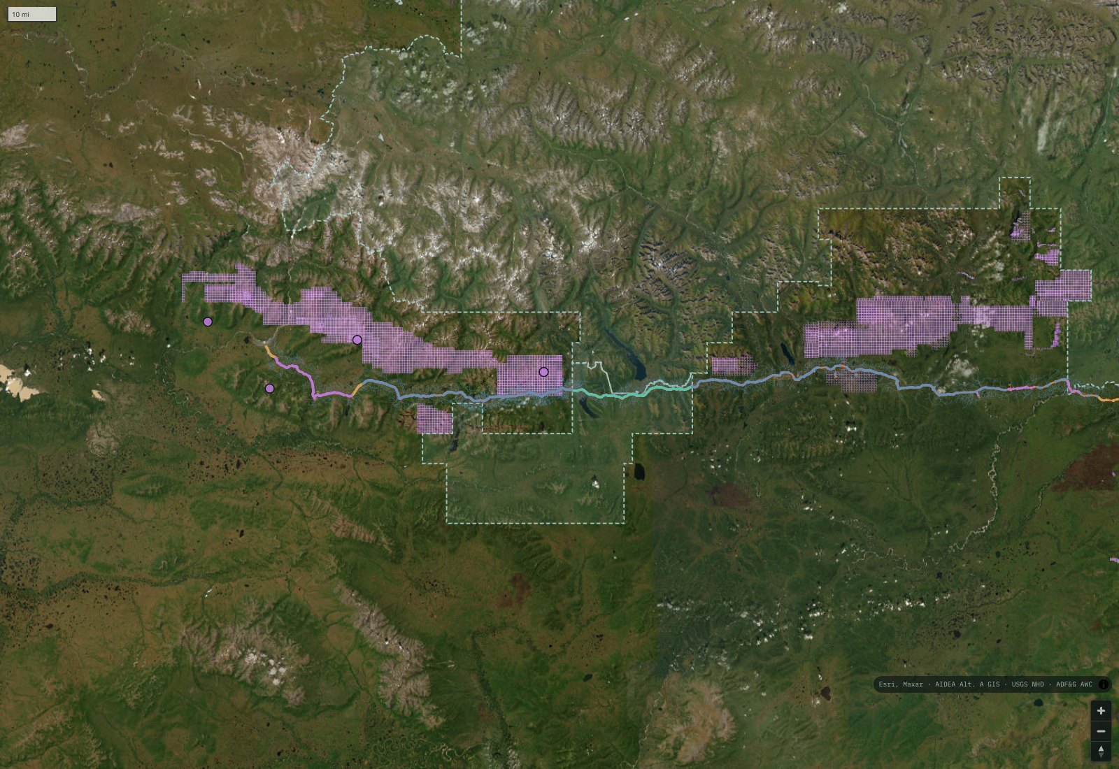
The proposed road, the four deposits, and every active state mining claim along the corridor as of the state's August 2026 records, drawn on our atlas. Violet blocks are claims. The dashed line is Gates of the Arctic. Claims cluster at the district in the west and, less often noticed, along the eastern end near the Dalton Highway.
| Holder | Active claims | Who they're |
|---|---|---|
| Ambler Metals LLC | 2,100 | The joint venture the road is for, half Trilogy Metals of Vancouver, half South32 of Australia |
| South32 USA Exploration Inc. | 1,393 | South32's own United States subsidiary, holding ground in its own name outside the joint venture |
| Valhalla Metals AK Inc. | 600 | Holder of the Sun deposit |
| Lux Copper LLC | 368 | All 368 located in October and November 2025 |
| 995 Exploration Inc. | 183 | A wholly owned subsidiary of Trilogy Metals, named as such in its 10-K |
| Individuals and others | 478 | Smaller holders, mostly named persons |
Alaska DNR, NaturalResource_StateMiningClaim feature service, layers 0 (active) and 1 (closed), pulled August 20, 2026 for the bounding box -157.65, 66.50 to -149.75, 67.66. Holder is the service's own customer name field. 995 Exploration as a Trilogy subsidiary: Trilogy Metals Form 10-K, p. 10.
Two names on that table matter beyond their totals. South32 is the company that sold the Department of War its Trilogy shares and that, with Trilogy, owns the joint venture; it also holds 1,393 claims in its own name along the corridor. And 995 Exploration is Trilogy itself. The road's beneficiaries hold ground along its length directly, not only at the deposits at its end.
AIDEA applied to build the road on November 24, 2015. Of the 5,122 active claims along the corridor, 3,431 were located after that date, covering 522,052 acres. State it as the temporal fact it is: two thirds of the claims along this corridor postdate the application to build a road through it.
| When the claims were located | Claims | What was happening |
|---|---|---|
| 2017 | 212 | Scoping for the environmental review |
| 2019 | 465 | Draft EIS published |
| June 2020 | 1,063 | The month before the first record of decision, July 2020 |
| 2021 | 654 | Right-of-way grant issued in January 2021, with the two lawsuits filed in 2020 pending |
| 2022 to 2024 | 266 | Permits suspended, supplemental review, denial in June 2024 |
| October and November 2025 | 504 | The President reinstated the permits on October 6, 2025. 368 by Lux Copper, 132 by Trilogy's subsidiary |
Alaska DNR state mining claim service, field NTPSTDT (date located), counted by us. The application date: AIDEA audited financial statements FY2025, p. 74.
We don't say the road caused the staking. We say that the claims along this corridor were located in waves, and that the waves line up with the permit decisions, and we let the reader do the arithmetic.
The figure most reporting carries is "roughly 1,700 claims." It's a real number from a real moment: through 2018, when the draft and final environmental statements were being written, the district box held 1,706 active claims. The live count in that same box is 2,744, about 60 percent higher, and the count along the whole corridor is 5,122. The 1,700 has been carried forward for six years by stories quoting stories.
There's a reason the number is easy to get wrong. There's no official "Ambler mining district" boundary in Alaska's state records. The state's own district layer calls this area Shungnak, and that polygon sits south of the mineral belt and contains none of these claims. "Ambler mining district" is an industry term, and any claim count depends on the box someone drew. Ours is the road's own bounding box, buffered by about half a degree, and it's stated in full above so that anyone can rerun it.
Counts by located date from the state service; the 2018 snapshot is our reconstruction from the same data, not a citation to whoever first published 1,700, which we could not trace to a public source.
A mine is reached by its own road off the corridor, and Trilogy's own filings describe the first one: "the Arctic access road from the Ambler Access Project intersection to the mine site will have to be constructed to at least a pioneer road condition" before mining can begin. Four mines in the federal scenario means four of those. Beyond the four, the ground the state has let is 649,057 acres of claims along 211 miles, and every claim that ever becomes a prospect needs a way in.
The record doesn't model those roads. Its cumulative analysis stops at four mines and the trucks they would put on the corridor. The map at the top of this page is the closest thing to a picture of what the corridor would open, because it's the state's own ledger of who has already staked what.
Trilogy Metals Form 10-K, p. 75 and p. 77 (the Arctic access road). 2024 Final SEIS, Appendix H (cumulative scenario, four mines).
What this chapter doesn't say
It doesn't say the claims were staked because of the road. It says when they were staked, and what was happening in the permit record at the time. The inference is the reader's.
It doesn't say the district is worthless. Arctic is a genuine high-grade deposit with a probable reserve, and copper is a genuine critical mineral. The case for mining it's real and it's made honestly in the chapter on the case for the road, still to come.
It doesn't say NANA opposes mining. NANA's own statements say the opposite: it kept its Ambler Metals partnership when it withdrew from the road, and its president said that "we maintain our interest in future mineral development in the region." What it withdrew from was the road, on stated grounds, and what it has since signed is a memorandum it describes as non-final.
It doesn't say where the ore would go. No buyer is under contract and no United States smelter is named in the company's technical report, which assumes a smelter in the Asia Pacific region. That's its own chapter, and it isn't the one you may have heard.
The federal analysis of the road assumes four mines in the district, and not one is permitted. The 2024 record of decision says so in one sentence: "no mines have been developed, and no plans of development are pending before the federal government." The first application, for the Arctic deposit, entered federal review in April 2026, and on September 21, 2026 Trilogy told its shareholders that the Army Corps had published the Notice of Intent to prepare that mine's environmental impact statement.
2024 Record of Decision, p. 24; Trilogy Metals news release, September 21, 2026.The two deposits the road is really for sit on private ground held two different ways. Arctic sits on 18 federal patented claims owned by Ambler Metals, the joint venture of Trilogy Metals and South32, ringed by Ambler Metals' state claims. Bornite sits on 25 patented claims, about 517 acres, that NANA Regional Corporation has owned since 1986.
Alaska Department of Natural Resources, state mining claim feature service; Trilogy Metals Form 10-K, FY2025.The State of Alaska carries 5,122 active mining claims on 649,057 acres along the corridor. 3,431 of them, 67 percent, were staked after AIDEA applied for the road on November 24, 2015. The "roughly 1,700 claims" figure that circulates is a 2018 snapshot of a smaller box.
Staking moves with the permits: 504 claims were located in the five weeks after the President reinstated them in October 2025, 368 of those by Lux Copper and 132 by Trilogy Metals' own subsidiary.
Alaska Department of Natural Resources, state mining claim feature service, our own count. Method on How We Know.The claims are counted from the State of Alaska's own live service, not from a download, because the bulk file is stale and the service truncates by response size rather than record count, which silently drops most of the data unless you page on its own flag. Every claim on our map carries its state case number so the record can be checked claim by claim. The deposits are from the record of decision and from Trilogy's own securities filings.
The road's federal analysis assumes four mines, and the government's own record says none has been developed. If you're a reporter, the question for the Bureau of Land Management is whether a right-of-way justified by four mines survives with one application and a 13-year reserve, and the question for AIDEA is what happens to the toll model if Bornite, on NANA's land, never proceeds.
Every claim on our map opens the state's own case file by its number. If a claim near your community changed hands or was staked in the autumn of 2025, the file will say by whom.