


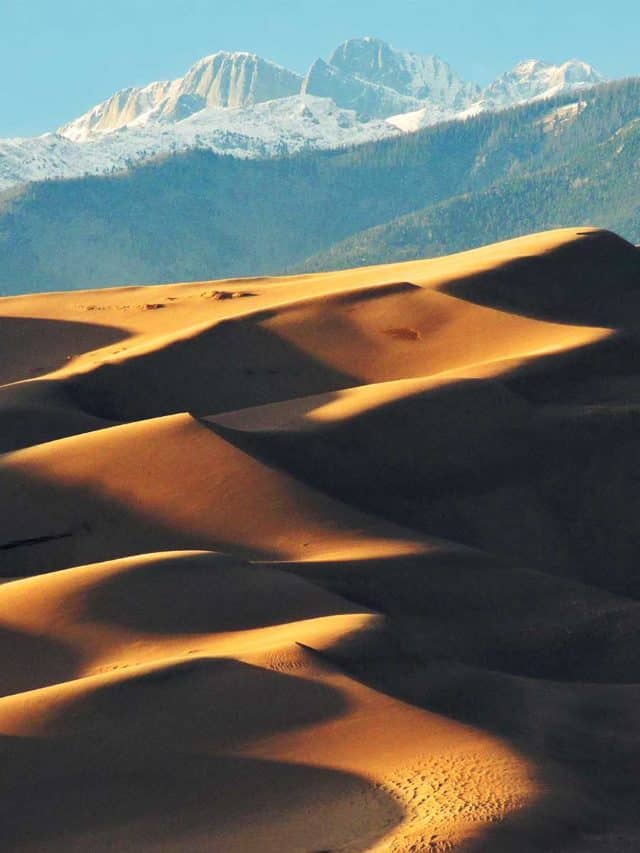
In southern Colorado’s San Luis Valley, a sea of sand covering about 30 square miles laps against the base of the Sangre de Cristo Mountains, and its tallest waves stand about 741 feet high. Nothing else in North America comes close. Great Sand Dunes National Park looks like the Sahara got lost on its way to the Rockies, and the strangest thing about it is that the sand is the least of the story.
What follows are 12 facts about the dunes, the water that holds them together, and the people who have known this valley for eleven millennia. For trip planning, trails, and campgrounds, start with our full Great Sand Dunes National Park guide.
Tony Pattiz taught American history for more than 25 years before he began writing it for this site. Will and Jim made the on-air case for this park when they picked Great Sand Dunes as a top spring destination in our Passport to the Parks series with The Weather Channel; the history below was built at the research desk from the primary record. Every date, number, and name has been checked against the National Park Service and the sources listed at the end of this article. Last verified July 2026.
Great Sand Dunes National Park Basics
- Location: San Luis Valley, southern Colorado, at the western base of the Sangre de Cristo Mountains
- Size: About 150,000 acres of park and preserve combined, per the NPS park FAQ
- Dunefield: The main dunefield covers about 30 square miles, ringed by an even larger sand sheet
- Tallest dune: Hidden Dune, 741 feet from base to crest, with Star Dune essentially tied (per NPS, as of 2026)
- Visitation: 432,498 recreation visits in 2025, per NPS Stats
- Established: Proclaimed a national monument in 1932, designated a national park and preserve in 2004
- Highest point: Tijeras Peak, 13,604 feet, in the park’s mountain preserve
- Designation: International Dark Sky Park since 2019
1. The Tallest Dune In North America Is Essentially A Tie
For decades the park told visitors that Star Dune, at 750 feet, was the tallest dune on the continent. Then the measuring improved, and the story got more interesting. The park’s current hiking guide lists Hidden Dune as the tallest in North America at 741 feet, with Star Dune just behind at 736 feet, while the park’s own profile pages call the two essentially tied at about 741 feet. Different NPS pages still disagree with each other by a few feet, and that tells you something true about this place. Dunes move, and the measuring never really ends.
Love Great Sand Dunes? It's one of 117 threatened public lands destinations we're tracking. Get the free briefing.
Here is the twist most visitors miss. The dune everyone photographs from the parking area is neither of them. High Dune on the first ridge rises about 688 feet and only looks like the champion because it stands out front. Hidden Dune earned its name honestly; it sits deep in the dunefield, a 7 mile round trip hike, and Star Dune is a 6 mile round trip. Either one is a serious half-day in soft sand.
2. The Sand Has Been Piling Up For Around 400,000 Years
How old are the dunes? The honest answer, straight from the NPS geology page, is that scientists don’t yet know a precise age, and the estimates have changed over time. The dunes were once thought to be young. Then researchers found that the sand extends about 300 feet below the valley floor, resting just above the deposits of ancient Lake Alamosa, a vast lake that once covered much of the valley. A USGS study dates the lake’s overflow and draining to about 440,000 years ago, and the Park Service says the lakes and the Rio Grande have fed sand to the dunes for the past 400,000 years. The sand itself washed down from the mountain ranges on both sides of the valley, and the shallow lakes left behind sorted it from the coarser sediment.
Why did the sand pile so high here and nowhere else? Opposing winds. The prevailing southwest winds push sand toward the Sangre de Cristos, and storm winds pour back down through the mountain passes in the opposite direction. Caught between them, the dunes grow up instead of out. Meanwhile Medano and Sand creeks capture sand off the mountain side of the dunefield and carry it back around to the valley floor, where the wind picks it up and returns it. The whole system is a slow, closed loop that has been running since before our species left Africa.
3. People Have Hunted This Valley For About 11,000 Years
The oldest confirmed evidence of humans here goes back about 11,000 years, and the National Park Service notes that the newest research keeps hinting at even earlier arrivals. The first people in the San Luis Valley were nomadic hunter-gatherers drawn by herds of mammoths and prehistoric bison grazing the basin. They hunted with the large stone spear and dart points archaeologists now call Clovis and Folsom points, stayed when hunting and plant gathering were good, and moved on during drought.
The animal at the center of that world takes some imagining. The Columbian mammoth was larger than the better known woolly mammoth, with grown males reaching about 13 feet at the shoulder and close to 22,000 pounds. A valley that could feed animals like that held lakes and lush plant life, nothing like the high desert you cross to reach the park today. Fossils and artifacts still surface in the region; if you ever find one, leave it in place and tell a ranger.
4. The Ute Name For The Dunes Means Sand That Moves
The Ute people, whose connection to this landscape runs back for generations beyond counting, know the Great Sand Dunes as Saa waap maa nache, “sand that moves,” according to the National Park Service. The Jicarilla Apache, who settled in northern New Mexico, know the dunes as Seinanyédi, “it goes up and down,” and the Navajo name translates as “sand comes back down on you.” All of them are field observations, and all of them are accurate.
Photographs from the late 1800s show the major dunes holding essentially the same shapes and positions they have today, but the surface never rests. Wind moves sand grain by grain through a process called saltation, lifting each grain, carrying it a short hop, and dropping it to knock loose the next. Stand on a windy ridge and you can watch the skin of the dune crawl past your boots, sand that moves, exactly as named.

5. A Women’s Club Saved The Dunes From The Cement Business
Who do you thank for this park? Start with a ladies’ club in the San Luis Valley. In the late 1920s, commercial interests eyed the dunes as raw material for making cement and glass. A local chapter of the P.E.O. Sisterhood, a women’s organization devoted to education, launched the campaign to save the dunes and lobbied Colorado’s state leaders, senators, and congressmen until Washington listened, as the NPS founding history records.
They got what they wanted. On March 17, 1932, President Herbert Hoover proclaimed Great Sand Dunes the 36th national monument in the park system, protecting 35,528 acres. It was one of only 5 monument proposals approved that year out of 90 submitted. The next time someone tells you letter-writing campaigns never work, hand them a sand sled.
6. It Became A National Park To Protect Water, Not Sand
The dunes are only the visible part of a water system, and it took a corporate water grab to prove it. In 1986, American Water Development Inc. unveiled a plan to pump San Luis Valley groundwater to Colorado’s growing Front Range cities. In the long court fight that followed, scientific data gathered by the Park Service showed the dunes are hydrologically connected to the valley’s surface water and groundwater; drain one and you starve the other. AWDI lost in 1991, another exporter called Stockman’s Water Company tried again in 1995, and local opposition forced it to abandon the scheme in 1998, a saga the Colorado Encyclopedia tells in full.
Locals, conservancy groups, and politicians of both parties concluded the only permanent fix was a bigger park. Congress passed the Great Sand Dunes National Park and Preserve Act in November 2000, and the deal hinged on acquiring the 97,000 acre Baca Ranch, the very ground the water schemes had eyed. The Nature Conservancy’s purchase satisfied the act, and in September 2004 Interior Secretary Gale Norton formally designated Great Sand Dunes National Park and Preserve, 149,512 acres in all. America’s tallest dunes became a national park so that nobody could ever sell the water out from under them.
7. Medano Creek Flows In Waves You Can Ride
Each late spring, snowmelt off the Sangre de Cristos sends Medano Creek sheeting across the flats at the base of the dunes, and the creek does something almost no other stream on Earth does. It surges. Little dams of sand build up on the smooth creekbed, water piles behind them, the dams break, and a wave rolls downstream, about one every 20 seconds. In wet years the waves can top a foot high, and the sandy shoreline turns into Colorado’s most improbable beach.
The Park Service calls Medano Creek one of the few places in the world to experience surge flow. In an average year the creek reaches the main dunes area in April, peaks in late May or early June, and dries up at the visitor area by midsummer, but the flow swings widely from year to year. Check the park’s current conditions before you drive out with the boogie boards.
8. The Sand Swings From 150 Degrees To Well Below Zero
Respect the surface you walk on. Per the park’s weather page, the sand surface can soar to 150 degrees F on a sunny summer afternoon, hot enough to injure bare feet and dog paws, even while the air reads a pleasant 75 to 80 degrees. Hot sand is the first hazard the Park Service lists for the dunefield, and it is why rangers steer everyone toward early morning and evening hours on the dunes, in closed, sturdy shoes.
Winter flips the extreme. Nighttime lows in the coldest stretch of winter average 15 below to 5 below zero F, and snow periodically dusts the dunes into a black and white photograph of themselves. The quiet season has its rewards; the crowds vanish, and the wildlife does not.

9. You Can Sandboard The Dunes With The Right Gear
This may be the most fun you will have in any national park. Sandboarding and sand sledding are permitted anywhere on the dunefield away from vegetated areas, which means your run is limited only by how far you are willing to climb. The catch is the gear. Snow sleds and snowboards only slide on wet sand, and cardboard simply digs in. Boards and sleds built for sand, with an extra slick base and special wax, are the only things that really fly.
The Park Service does not rent equipment, so pick it up before you arrive from outfitters in the San Luis Valley; the nearest sits a few miles outside the park entrance. Then follow the rangers’ standing advice and ride in the morning or evening, when the sand is cool and the afternoon storms are somewhere else.

10. The Dunes Hum When The Sand Avalanches
My favorite fact about this park is that the dunes make music. During a sand avalanche, air pushed through millions of tumbling grains produces a deep, resonant hum, with the dune itself acting as the amplifier. The Park Service’s natural sounds program counts Great Sand Dunes among the few places in the world where you can hear it. Avalanches happen naturally during storms, or you can start a small one by pushing sand down a steep dune face and listening.
The singing sands were famous enough by the Second World War that Bing Crosby recorded a song named for them, “The Singing Sands of Alamosa,” in 1942, taking the title from the town down the road. Not many geology lessons come with a crooner.
11. It Is A Certified International Dark Sky Park
In 2019, Great Sand Dunes was certified an International Dark Sky Park, a designation that recognizes both the quality of the night sky and the park’s work to keep it dark. The recipe is simple and increasingly rare. Dry air, high elevation, and very little light pollution.
On a moonless night the Milky Way arcs over the dunefield bright enough to hike by, and the park runs summer night sky programs on exactly that theme. Many visitors climb the dunes after dark once the sand cools, either under the stars or by the light of a full moon, when the whole dunefield glows.
12. The Wildlife Is Richer Than A Sea Of Sand Suggests
A landscape that looks like the Sahara should be empty. It is not, though only one mammal can call the dunefield itself home. According to the park’s wildlife pages, Ord’s kangaroo rats can live their entire lives in the main dunefield without ever drinking water. Around the edges the cast fills out fast. Mule deer are the most commonly seen mammal in the park, mountain lion tracks thread along Medano Creek, Abert’s squirrels with their rabbit-like ears go by the joking nickname “scrabbits,” pronghorn hit 60 mph on the grasslands, about 2,000 bison are managed within park boundaries on Nature Conservancy land, and over 4,000 elk roam the eastern side of the valley.
The birds may top them all. More than 250 species have been documented in the park’s habitats, from wetlands to alpine tundra, and each spring more than 20,000 sandhill cranes stage in the San Luis Valley on their way north, arriving in early February and heading on by late March. They stop again on the southbound trip in fall. It is one of the great wildlife spectacles in Colorado, staged against a wall of sand.

How To See The Dunes For Yourself
We will be straight with you about our experience here. Will and Jim have championed this park on national television, telling The Weather Channel’s Passport to the Parks audience to put Great Sand Dunes on their May calendar, and this section is built on the rangers’ own guidance rather than our field notebooks. Their playbook is a good one. Climb the first ridge to High Dune at dawn, a 2.5 mile round trip that puts the whole dunefield at your feet before the sand heats up. Come in late May if you want Medano Creek’s surge flow running beside your basecamp. When the sand bakes, escape into the trees on the Mosca Pass Trail, 3.5 miles one way along a creek through aspen and evergreen, or the short, shaded Montville loop. And stay past sunset at least once; the dark sky is half the park.
Four-wheel-drive owners can continue up the Medano Pass Primitive Road, but its condition changes with sand and creek levels; check the park’s current conditions page before committing. For the full rundown of hikes, seasons, and campgrounds, our guide to the best things to do in Great Sand Dunes National Park ranks it all.

Where These Facts Come From
Every claim in this article was checked against the sources below in July 2026. Numbers that change over time, like dune heights and annual visitation, are stated with the year they were reported.
- NPS, Great Sand Dunes Frequently Asked Questions, for park acreage, dunefield size, sand temperatures, and Tijeras Peak
- NPS, Great Sand Dunes Hiking, with the Star Dune and Hidden Dune profiles, for current dune heights and hike distances
- NPS, Great Sand Dunes Geology and USGS, Ancient Lake Alamosa and the Evolution of the Rio Grande (Machette and others, 2007), for Lake Alamosa, sand depth, dune age, and the 440,000 year overflow date
- NPS, Paleo and Archaic Cultures and NPS, Columbian Mammoth, for the first people and the animals they hunted
- NPS, The Indian Grove and NPS, Affiliated Tribes of Great Sand Dunes, for the Ute, Jicarilla Apache, and Navajo names for the dunes
- NPS, Great Sand Dunes’ Founding Legislation, A Timeline and NPS, National Monument and National Park Status, for the P.E.O. campaign, the 1932 proclamation, and the 2000 and 2004 milestones
- Colorado Encyclopedia, Great Sand Dunes National Park and Preserve (Michael M. Geary) and the US Fish and Wildlife Service’s Baca refuge plan, for the water export battles, the 97,000 acre Baca Ranch purchase, and the 149,512 acre total
- NPS, Medano Creek, for surge flow and the creek’s average season
- NPS, Great Sand Dunes Weather and NPS, Sandboarding and Sand Sledding, for temperature extremes and the sandboarding rules
- NPS Natural Sounds, Singing Sands and the Internet Archive’s 1942 Bing Crosby recording, for the booming dunes and the song they inspired
- NPS, Experience the Night and DarkSky International, for the 2019 Dark Sky Park certification
- NPS, Mammals, NPS, Birds, NPS, Sandhill Crane Migration, and NPS Stats (IRMA), for the wildlife figures and 2025 recreation visits
Keep Exploring Great Sand Dunes
- Great Sand Dunes National Park Guide, our full trip planning hub
- Things To Do In Great Sand Dunes National Park, every hike and season ranked
- Colorado National Parks Worth Visiting
- Black Canyon Of The Gunnison Facts, more Colorado geology done strange
- Mesa Verde National Park Facts, more deep human history from Colorado
- Before you go, check live alerts and air quality on our national park conditions dashboard
What to Bring to Great Sand Dunes
Gear we recommend for Great Sand Dunes. Affiliate links support our work at no cost to you.
More Than Just Parks may earn a small commission from purchases made through these links, at no extra cost to you. We only recommend gear we would actually use.
Affiliate disclosure: Some links on this page earn us a small commission at no extra cost to you. We only recommend gear we actually use.


