Late on the afternoon of May 22, 1915, a mountain in northern California exploded. The blast from Lassen Peak threw a column of ash and gas more than 30,000 feet into the sky, flattened three square miles of forest, and rained fine ash on Winnemucca, Nevada, 200 miles to the east. It was the last eruption in the Cascade Range until Mount St. Helens in 1980, and the country was so astonished that Congress made the volcano a national park the following summer.
What follows are 13 verified facts about Lassen Volcanic National Park, the people who named it, photographed it, and nearly lost their lives in it. For trails, hydrothermal areas, and trip planning, start with our full Lassen Volcanic National Park guide.
Tony Pattiz taught American history for more than 25 years before he began writing it for this site, and Lassen’s story of eruptions, emigrant trails, and an unsolved frontier murder is the kind of history he taught for decades. This piece leans on the rangers and scientists who know it best, along with the named viewpoints in the How To See It section below. Every date, number, and name has been checked against the National Park Service, the U.S. Geological Survey, and the primary sources listed at the end of this article. Last verified July 2026.
Lassen Volcanic National Park Basics
- Location: Northern California, at the southern end of the Cascade Range, northeast of Redding
- Size: 106,589 acres, per the NPS Geodiversity Atlas
- Highest point: Lassen Peak, 10,457 feet
- Visitation: 504,777 recreation visits in 2025, per NPS Stats
- Established: August 9, 1916, built from two national monuments proclaimed in 1907
- Wilderness: 78,982 acres of the park designated as wilderness in 1972
1. All Four Types Of Volcano On Earth Stand Inside This One Park
Geologists sort the world’s volcanoes into four types, and Lassen is the rare place that holds a full set. According to the U.S. Geological Survey, all four are represented in the park. Prospect Peak is the shield volcano, Lassen Peak the plug dome, Cinder Cone the cinder cone, and Brokeoff Volcano the composite.
Love Lassen Volcanic? It's one of 117 threatened public lands destinations we're tracking. Get the free briefing.
The engine under all of it is the Lassen Volcanic Center, which the National Park Service says began erupting about 825,000 years ago and remains the most recently active volcanic center in the park’s corner of the Cascades. That restless plumbing is why the ground here still boils, steams, and roars in a way no other California park can match.
2. Lassen Peak Is One Of The Largest Lava Domes On Earth
Lava domes form when molten rock is too thick to flow away, so it piles up over its own vent like toothpaste squeezed from a tube. More than 30 of them have erupted in the Lassen area over the past 300,000 years, and Lassen Peak is the largest of the group. At 10,457 feet, the Park Service calls it one of the world’s largest plug dome volcanoes.
The USGS puts numbers on that superlative. The dome rises 2,000 feet above its surroundings, holds roughly half a cubic mile of rock, and formed about 27,000 years ago, probably in only a few years. Think about that. A 10,000 foot mountain, assembled within a human lifetime.
3. The Mountain Wore At Least Five Names Before Lassen Peak Became Official
What do you call a mountain that keeps changing hands? The park’s own history timeline reads like a naming contest that ran for a century. Spanish padres traveling with Don Luis Arguello’s 1821 expedition called it San Jose. In 1827 the mountain man Jedediah Smith named it Mt. Joseph, though he applied the name to the whole range he could see. Emigrants of the 1840s knew it as Snow Butte, and Peter Lassen himself called it and neighboring Brokeoff Mountain the Sister Buttes in 1844.
The name Lassen Peak was not officially adopted until June 2, 1915. The timing is hard to beat. The mountain received its permanent name eleven days after the most violent eruption in its recorded history.
4. Peter Lassen Guided Emigrants West And Died In A Murder Never Solved
The park’s namesake was a Danish blacksmith, born near Farum, Denmark, in 1800, who worked as a master blacksmith in Copenhagen before sailing for Boston in 1830. He kept moving west until there was no more west to move to. By 1844 he had taken Mexican citizenship and secured Rancho Bosquejo, a 22,000 acre grant at the mouth of Deer Creek, where he tried to build a town called Benton City that never took hold.
In the fall of 1848 Lassen led a wagon train into California along the route that became known as the Lassen Trail. It was not a kind road. The park timeline records that the traveler J. Goldsborough Bruff, left behind sick in these mountains in 1849, nearly starved through the winter waiting for companions who never returned.
Lassen’s own end was darker still. On April 26, 1859, while prospecting near what is now Clapper Creek, he was shot and killed by an unknown party along with his companion Edward Clapper. A third man, Wyatt, survived. No one was ever charged, and the murder of the man whose name is on this park remains unsolved.
5. Two Gold Rush Trails Still Cross The Park
Lassen’s trail was not the only road through this country. According to the National Park Service, two pioneer trails developed by William Nobles and Peter Lassen are associated with the park, and sections of both are still visible today.
Nobles found his route in 1851 while hunting for a rumored gold lake, and he understood exactly what a shorter, easier road to California was worth. In May 1852 the citizens of Shasta paid him a $2,000 subscription in exchange for revealing it. His road carried emigrants past Manzanita Lake for decades, and a 24 mile portion of the Nobles Emigrant Trail inside the park was placed on the National Register of Historic Places in 1975. Walk it today and you are walking in wagon ruts.
6. The Lassen Area Was A Meeting Point For At Least Four Tribes
Long before any of those names went on maps, this volcanic high country was shared ground. The National Park Service identifies the Lassen area as a meeting point for at least four Native American groups. The Atsugewi wintered along Hat Creek and moved up into the present park in spring and summer. The Yana and Yahi lived most of the year in the foothills along Mill Creek and followed the deer herds to higher ground each summer. The Mountain Maidu made the southern and eastern Lassen region home, including Warner Valley and Juniper Lake.
Deep snow and high elevation made year round living here impractical, so the mountain was a seasonal gathering place rather than a permanent home. That relationship never ended. Tribal members still work with the park on exhibits and cultural demonstrations, and when the park opened its year round visitor center in 2008, it carried a Mountain Maidu name, Kohm Yah-mah-nee, the first park facility to receive a tribal name.
7. In 1914 Lassen Peak Woke From A 27,000 Year Sleep
On May 30, 1914, in the words of the U.S. Geological Survey, Lassen Peak awoke from a 27,000 year long slumber with a steam explosion at its summit. Over the following year, more than 180 steam explosions blasted out a crater 1,000 feet wide. Then, on the evening of May 14, 1915, the eruption changed character. Incandescent blocks of lava could be seen bouncing down the mountain’s flanks from Manton, 20 miles away, and by morning a dome of fresh lava had filled the summit crater.
Late on May 19 a steam explosion shattered that dome. Glowing blocks of hot lava fell onto deep snow and launched a half mile wide avalanche that roared 4 miles down the northeast flank, melting snow into a lahar, a mudflow of volcanic debris, that ran 7 miles down Lost Creek. The floodwaters it released swept the lower Hat Creek Valley in the early morning hours of May 20, destroying six mostly unoccupied ranch houses. Remarkably, the few people in them escaped with only minor injuries.
8. The May 22, 1915 Blast Was The Last Cascades Eruption Before Mount St. Helens
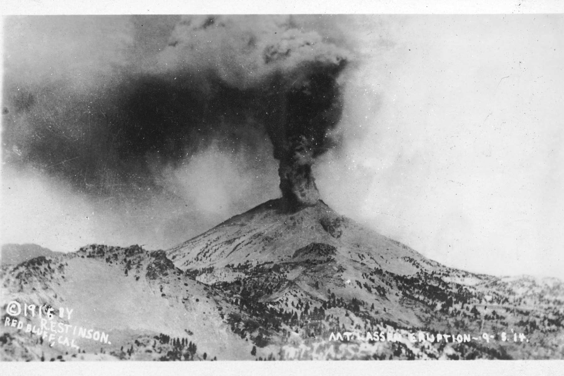
After two quiet days, the mountain delivered its climactic act. Late on the afternoon of May 22, 1915, Lassen Peak exploded, blasting rock and pumice skyward and carving the larger of the two craters visible near the summit today. The ash column rose more than 30,000 feet and could be seen from Eureka, 150 miles to the west. A pyroclastic flow, a high speed avalanche of hot ash, pumice, and gas, swept down the northeastern slope and devastated a 3 square mile area that the park still calls the Devastated Area. A new lahar rushed nearly 10 miles down Lost Creek to Old Station, and fine ash fell at least as far away as Winnemucca, Nevada, 200 miles east.
Steam explosions continued as late as May 1917, blasting out the summit’s second crater, and steam vents lingered near the top into the 1950s. Then the Cascades went quiet. No volcano in the range erupted again until Mount St. Helens in 1980. For the story of what a Cascade volcano can do on a far larger scale, read our Crater Lake National Park facts, where an eruption 7,700 years ago destroyed the entire mountain.
9. B.F. Loomis Photographed The Eruption And Helped Turn It Into A Park
How does a shake cutter from Manzanita Lake end up shaping a national park? Benjamin Franklin Loomis had arrived in northern California as a child by way of the Nobles Emigrant Trail. When word reached him on May 30, 1914 that Lassen Peak was erupting, he went toward the volcano, not away from it. In June he shot a series of six exposures that brought the eruption into the national spotlight and supported the campaign to establish Lassen Volcanic National Park. The USGS credits Loomis with making these some of the first volcanic eruptions ever extensively photographed.
Loomis spent the rest of his life giving the park what he had captured. He and his wife Estella dedicated a museum at Manzanita Lake on July 4, 1927, built in memory of their daughter Mae, who had died of influenza on January 13, 1920. On February 4, 1929, the couple deeded the museum, a seismograph building, and their 40 acres to the park. The Loomis Museum still shows his eruption photographs today, exactly the preservation of the volcano’s record that Loomis said he was building it for. He died in 1935 at 78, and Estella’s remaining property came to the park after her death in 1953.
10. The Park Began As Two Theodore Roosevelt Monuments
Lassen Volcanic National Park existed before it was a park, twice over. On May 6, 1907, President Theodore Roosevelt proclaimed Cinder Cone and Lassen Peak as separate national monuments, protecting the two most dramatic volcanic features in the region.
Then the mountain made its own argument. After the 1914 awakening, Lassen Peak was the only active volcano in the contiguous United States, precisely the kind of superlative Congress looked for in a national park. Congressman John Raker’s bill passed in the summer of 1916, and President Woodrow Wilson signed it on August 9, 1916, combining the two monuments and the land around them into Lassen Volcanic National Park. It is one of the oldest parks in the system, created while its centerpiece was actively erupting.
11. Bumpass Hell Is Named For A Man Who Lost His Leg There
Kendall Vanhook Bumpass filed a claim on the park’s largest hydrothermal basin in 1864, and the ground he claimed took his leg the following year. Guiding a newspaper editor to the site in 1865, Bumpass broke through the thin crust and plunged a leg into a boiling pool. The burns were so severe the leg had to be amputated, and the steaming basin has carried his name, and his warning, ever since.
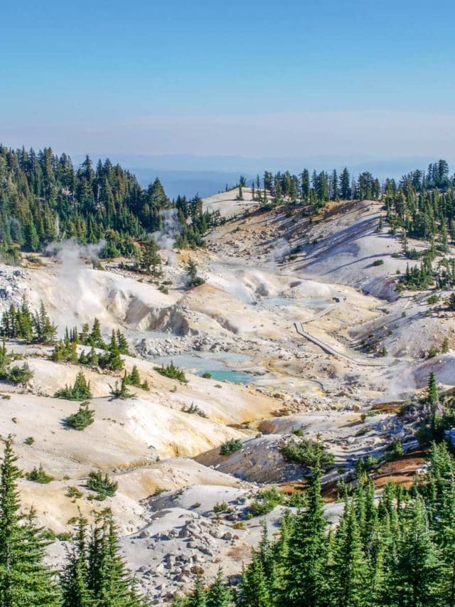
Today a boardwalk carries visitors safely over the 16 acre basin of Bumpass Hell, the largest hydrothermal area in the park. Its showpiece, Big Boiler, is one of the hottest hydrothermal fumaroles in the world. The USGS has measured the steam jetting from it as high as 322 degrees Fahrenheit. The crust here is still thin and the water is still boiling. In 2012 a visitor who stepped off the walkway at Sulphur Works broke through one inch of solid looking ground into boiling acidic mud. Stay on the boardwalk. Bumpass already ran the experiment.
12. A Sitting President Spent The Night At Manzanita Lake
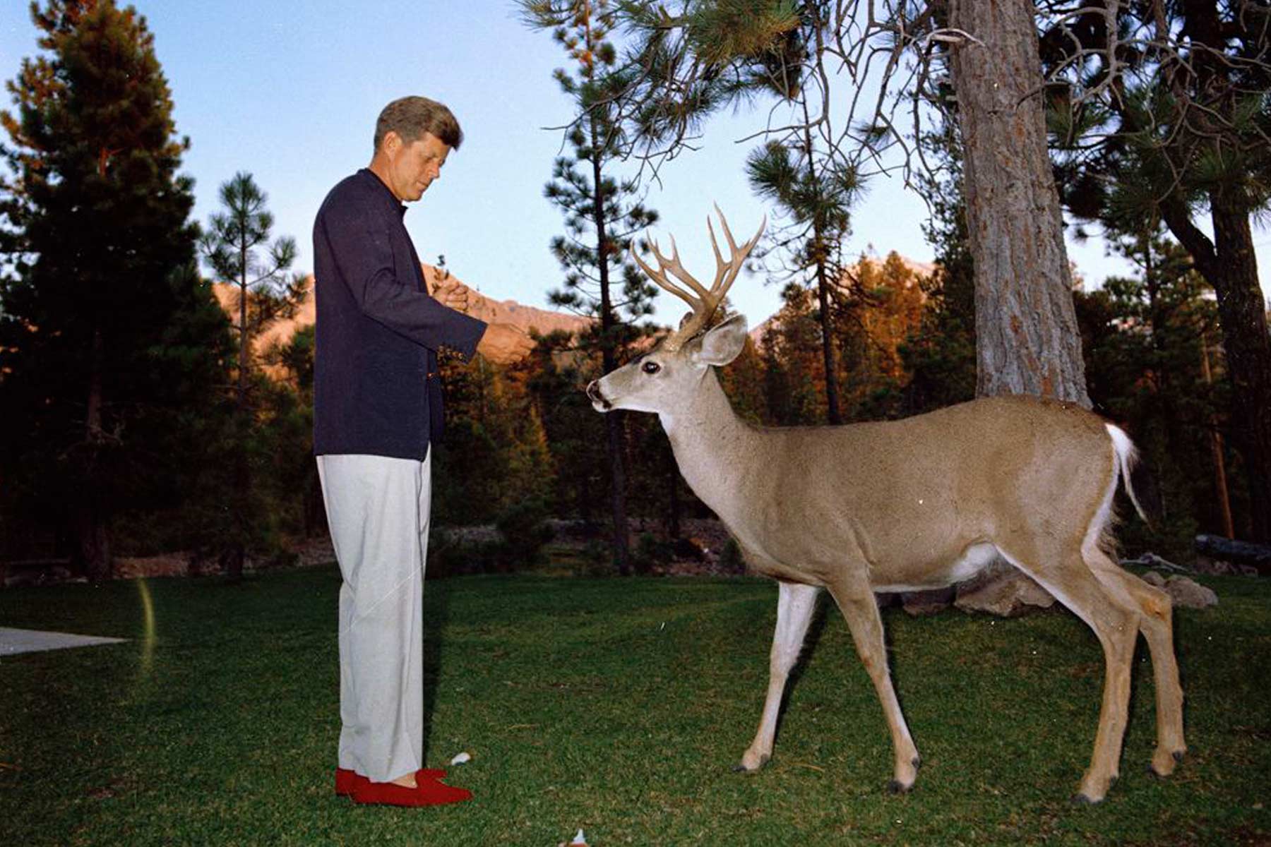
On September 27 and 28, 1963, President John F. Kennedy visited Lassen Volcanic National Park during his five day conservation tour across eleven states, a trip organized with Interior Secretary Stewart Udall and Senator Gaylord Nelson to push conservation onto the national agenda. Kennedy arrived by helicopter from Redding at the Devastated Area, of all places, and drove to Manzanita Lake with Udall, Press Secretary Pierre Salinger, and California Governor Pat Brown.
While the press corps walked a nature trail around the lake, the President rested at the Manzanita Lake Lodge manager’s residence, the building visitors now know as the Discovery Center. He was photographed feeding a deer on the lawn, and he reportedly told the superintendent that running a national park was the best job in the world. Eight weeks later he was gone, and the photographs from that quiet evening at Manzanita Lake became some of the last images of Kennedy at ease outdoors.
13. The 2021 Dixie Fire Burned More Than Two Thirds Of The Park
The park’s newest chapter is its hardest. The Dixie Fire started on July 13, 2021 in the Feather River Canyon southeast of the park and crossed the boundary near Juniper Lake on August 5. By September 30 it had burned 73,240 acres inside the park, more than two thirds of Lassen’s 106,589 acres, and yet that was only about 8 percent of the fire’s full footprint. At containment in October 2021 the Dixie Fire had covered 963,309 acres, at the time the largest single fire in California history.
The park’s framing since then has been recovery, not ruin. Fire moved through the park in a mosaic, severe in some drainages and light in others, and park partners launched a Lassen Resilience campaign to support the recovery. Visitors today see both truths at once, blackened snags on one ridge and green regrowth on the next, the newest layer in a park whose whole story is destruction and return.
How To See Lassen’s Volcanic Story Yourself
Here is the ranger tested way to walk this history. The Sulphur Works sidewalk puts you beside boiling mudpots minutes from the Southwest Entrance. The 3 mile round trip Bumpass Hell Trail, open roughly June through October, ends at the boardwalk over the park’s largest hydrothermal basin. At the Devastated Area Interpretive Trail you can stand next to a house sized chunk of the 1915 lava dome that the avalanche carried down the mountain, and the Loomis Museum at Manzanita Lake displays the eruption photographs from fact 9.
One planning note matters more here than in most parks. The 30 mile park highway is buried under as much as 30 to 40 feet of snow each winter, and its opening date changes every year, so check the park’s current conditions page before you commit to a date. Our guide to the best things to do in Lassen Volcanic National Park ranks every stop along the road.

Where These Facts Come From
Every claim in this article was checked against the sources below in July 2026. Numbers that change over time, like annual visitation and fire recovery status, are stated with the year they were reported.
- USGS Fact Sheet 173-98, Eruptions of Lassen Peak, California, 1914-1917, for the eruption sequence, the dome’s size and age, and the R.E. Stinson photograph record
- USGS, The 1914-1917 Eruption of Lassen Peak, for the May 22, 1915 climax and the last eruption in the Cascades before Mount St. Helens
- USGS, Lassen Volcanic National Park, for the four volcano types and their named examples
- USGS Fact Sheet 101-02, Hot Water in Lassen Volcanic National Park, for Big Boiler’s 322 degree steam and the Lassen hydrothermal system
- NPS, Volcanoes at Lassen Volcanic National Park, for the Lassen Volcanic Center’s 825,000 year history
- NPS, Lassen Peak Scenic Vista, for the peak’s 10,457 foot elevation and plug dome standing
- NPS, Lassen History Timeline, and the California Trail Interpretive Center, for the mountain’s names, Peter Lassen’s life and death, the Nobles Trail, and the Bumpass dates
- NPS, American Indian Tribes at Lassen, for the four tribes and the Kohm Yah-mah-nee Visitor Center
- NPS, Benjamin Franklin Loomis and NPS, Loomis Museum, for the eruption photographs and the museum’s history
- NPS news release, Cinder Cone and Lassen Peak National Monuments centennial, for the 1907 proclamations and the 1916 park campaign
- NPS, John Fitzgerald Kennedy at Lassen, for the 1963 presidential visit
- NPS, Dixie Fire, for the 2021 fire’s dates and acreage
- NPS Geodiversity Atlas, Lassen Volcanic National Park and NPS Stats (IRMA), for park acreage and 2025 recreation visits
Keep Exploring Lassen Volcanic
- Lassen Volcanic National Park Guide, our full trip planning hub
- Best Things To Do In Lassen Volcanic National Park
- California National Parks Ranked
- Redwood National Park Facts, more verified history from northern California
- Best National Parks Near San Francisco
- Before you go, check live alerts and air quality on our national park conditions dashboard
What to Bring to Lassen Volcanic
Gear we recommend for Lassen Volcanic. Affiliate links support our work at no cost to you.
More Than Just Parks may earn a small commission from purchases made through these links, at no extra cost to you. We only recommend gear we would actually use.
Affiliate disclosure: Some links on this page earn us a small commission at no extra cost to you. We only recommend gear we actually use.