
Comments closed October 19 · decided
Stop geothermal leasing on 29,477 acres of Deschutes National Forest
U.S. Forest Service · Deschutes National Forest, OR
- What
- The Forest Service may open nearly 30,000 acres of Deschutes National Forest to geothermal drilling.
- Where
- Deschutes National Forest, OR
- How much
- approximately 29,477 acres nominated National Forest acres proposed for geothermal leasing; approximately 25 air miles southeast distance from Bend, Oregon
- Decided
- Comments closed October 19, 2026. The decision is on file: CTL_DN_FONSI_Signed_2014_10_10. Open it ↗Date from Forest Service CARA comment page ↗, read October 29, 2026.
Where these four lines come from
- WhatOur plain-English read of the Forest Service project page ↗. Check it against the agency’s own words under Case.
- WhereThe places and states the project page names, as PLAN read them.
- approximately 29,477 acres“grant consent to lease approximately 29,477 acres of nominated National Forest System lands for geothermal exploration and development” Project Overview Open the document ↗
- approximately 25 air miles southeast“approximately 25 air miles southeast of Bend, Oregon” Project Overview Open the document ↗
- DecidedOctober 19, 2026, from Forest Service CARA comment page, the notice text ↗: “requested through 10/19/2026 11:59:59 PM (Pacific Standard Time)”. Read October 29, 2026. The decision document is the one on file in PLAN’s record.
- Read from PLAN’s record November 9, 2026.
What the proposal said, and what the decision did
No figure from the proposal has been checked against the decision on this fight yet. What the record does hold is the issues ledger below.
Did the agency answer?
PLAN found 5 issues in the agency’s notice. They’re waiting to be read against the decision.
The issues, awaiting the decision
PendingThe notice treats geothermal exploration and development as a single undivided action without distinguishing between exploratory drilling - test wells, access roads, fluid injection testing - and full commercial development, which could include power plant construction, transmission lines, and decades of continuous operation on nearly 30,000 acres (Project Overview).
The notice treats geothermal exploration and development as a single undivided action without distinguishing between exploratory drilling - test wells, access roads, fluid injection testing - and full commercial development, which could include power plant construction, transmission lines, and decades of continuous operation on nearly 30,000 acres (Project Overview).
NEPA requires analysis of the full scope of reasonably foreseeable future actions connected to the initial consent decision, not just the first exploratory phase. The EA must analyze exploration and development as distinct phases, disclose what activities the consent to lease authorizes at each phase, and analyze the full build-out that a successful exploration program would support.
A hole PLAN found in the agency’s own notice
PendingThe notice gives only a geographic location - the Bend-Fort Rock Ranger District, approximately 25 air miles southeast of Bend - as the entire baseline for 29,477 acres nominated for geothermal leasing (Project Overview).
The notice gives only a geographic location - the Bend-Fort Rock Ranger District, approximately 25 air miles southeast of Bend - as the entire baseline for 29,477 acres nominated for geothermal leasing (Project Overview).
No water resources, groundwater systems, wildlife species, recreation uses, cultural sites, or tribal values within the nominated acres are identified anywhere in the notice. Without a baseline the public cannot evaluate whether an EA is adequate or identify which resources should be prioritized in comments. Before the draft EA comment period opens, the agency must release an affected environment description covering at minimum water resources, wildlife, recreation, and cultural resources within the nominated lease area.
A hole PLAN found in the agency’s own notice
PendingThe notice labels consent to lease 29,477 acres of National Forest System land for geothermal exploration and development 'an administrative action only' but leaves that phrase completely undefined (Project Overview).
The notice labels consent to lease 29,477 acres of National Forest System land for geothermal exploration and development 'an administrative action only' but leaves that phrase completely undefined (Project Overview).
The label could be used to exclude from the EA entire categories of impact - subsurface water effects, induced seismicity, surface infrastructure - without telling the public which categories are out of scope or why. The agency must define 'administrative action only' in the EA, identify which categories of impact that framing excludes from analysis, and provide the legal basis for any such exclusion.
A hole PLAN found in the agency’s own notice
PendingThe notice selects an Environmental Assessment for a consent to lease on 29,477 acres nominated for geothermal exploration and development without any extraordinary circumstances screening, any explanation of why an action of this scale does not significantly affect the human environment, and no discussion of why an EIS is not required (Project Overview).
The notice selects an Environmental Assessment for a consent to lease on 29,477 acres nominated for geothermal exploration and development without any extraordinary circumstances screening, any explanation of why an action of this scale does not significantly affect the human environment, and no discussion of why an EIS is not required (Project Overview).
Geothermal development involves subsurface drilling, fluid injection, potential induced seismicity, and surface facility construction on a very large footprint. The agency should either prepare an EIS or provide in the EA a complete extraordinary circumstances analysis with site-specific rationale explaining why significant impacts are not expected across this acreage.
A hole PLAN found in the agency’s own notice
PendingThe notice records a NEPA start date of April 22, 2026, and an expected decision of April 2027, but provides no scoping notice, no comment deadline, no list of issues to be analyzed, and no date for a draft EA (Project Overview).
The notice records a NEPA start date of April 22, 2026, and an expected decision of April 2027, but provides no scoping notice, no comment deadline, no list of issues to be analyzed, and no date for a draft EA (Project Overview).
The milestone table lists a 'Finding/Decision Date' field with no date filled in. The public has no way to know when or how to participate in the process for a decision affecting nearly 30,000 acres. The agency must publish a scoping notice with a defined comment period, identify the key issues the EA will address, and disclose the full schedule including draft EA release and the target Finding/Decision Date.
A hole PLAN found in the agency’s own notice
PLAN's read: high threat
The Forest Service may open nearly 30,000 acres of Deschutes National Forest to geothermal drilling.
What’s at risk
If this goes through
Our plain-English read of the official notice ↗. Check it against the agency’s own words below.
By the numbers, from the agency’s own document
- Nominated National Forest acres proposed for geothermal leasing
Project Overview
Open the document ↗“grant consent to lease approximately 29,477 acres of nominated National Forest System lands for geothermal exploration and development”
- Distance from Bend, Oregon
Source: the agency’s document ↗
The agency’s own analysis
What the notice says, and what it leaves out
The window has closed; the record of what was missing stays.
The agency says
“approximately 29,477 acres of nominated National Forest System lands for geothermal exploration and development. This decision is an administrative action only.”
The notice labels consent to lease 29,477 acres of National Forest System land for geothermal exploration and development 'an administrative action only' but leaves that phrase completely undefined (Project Overview).
The agency says
“to grant consent to lease approximately 29,477 acres of nominated National Forest System lands for geothermal exploration and development”
The notice selects an Environmental Assessment for a consent to lease on 29,477 acres nominated for geothermal exploration and development without any extraordinary circumstances screening, any explanation of why an action of this scale does not significantly affect the human environment, and no discussion of why an EIS is not required (Project Overview).
The agency says
“The Deschutes National Forest is responding to a Bureau of Land Management (BLM) request to grant consent to lease approximately 29,477 acres”
The notice records a NEPA start date of April 22, 2026, and an expected decision of April 2027, but provides no scoping notice, no comment deadline, no list of issues to be analyzed, and no date for a draft EA (Project Overview).
The agency says
“grant consent to lease approximately 29,477 acres of nominated National Forest System lands for geothermal exploration and development”
The notice treats geothermal exploration and development as a single undivided action without distinguishing between exploratory drilling - test wells, access roads, fluid injection testing - and full commercial development, which could include power plant construction, transmission lines, and decades of continuous operation on nearly 30,000 acres (Project Overview).
The agency says
“located within the Deschutes National Forest on the Bend-Fort Rock Ranger District, Deschutes County, approximately 25 air miles southeast of Bend, Oregon”
The notice gives only a geographic location - the Bend-Fort Rock Ranger District, approximately 25 air miles southeast of Bend - as the entire baseline for 29,477 acres nominated for geothermal leasing (Project Overview).
In the agency’s own words
The Deschutes National Forest is responding to a Bureau of Land Management (BLM) request to grant consent to lease approximately 29,477 acres of nominated National Forest System lands for geothermal exploration and development. This decision is an administrative action only.
The groups on this fight
4 groups predicted likely to care in Oregon
Predicted likely to care is a guess from the group's sourced work in Oregon, with no link to this decision. Give straight to them; nothing routes through us.
- Cascadia Wildlands
Predicted likely to care · a guess
Western Oregon O&C Lands, Oregon: Serial litigant against western Oregon BLM logging, from the 2016 management plan challenge to the current round of timber sale suits.
- Crag Law Center
Predicted likely to care · a guess
Western Oregon O&C Lands, Oregon: Counsel of record for the conservation groups fighting BLM logging across the O&C forests.
- Oregon Natural Desert Association
Predicted likely to care · a guess
McDermitt Caldera, Oregon: Anchors the McDermitt Caldera Coalition on the Oregon side and fought the BLM's December 2025 approval of the Jindalee/HiTech lithium exploration project through the permitting process.
- Oregon Wild
Predicted likely to care · a guess
Western Oregon O&C Lands, Oregon: Its attorneys, with Cascadia Wildlands and Crag Law Center, represent the groups challenging BLM's Blue and Gold old-growth logging project in the Coast Range.
Every group above is on STAND for Public Lands, with its court record, its filings and who backs it.
Who signs it
PLAN hasn’t read a signer into its record for this fight. The decision on file carries the signature: CTL_DN_FONSI_Signed_2014_10_10 ↗.
The ground
The window has closed, so there’s no watch to set on it here.
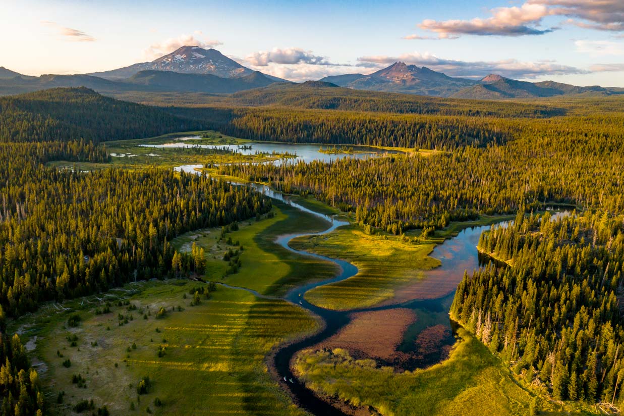
The photograph on this page: Deschutes National Forest, Oregon. More Than Just Parks.
In court on this ground
One court case is over Deschutes National Forest, newest first.
Docket closed · no date on file
The court closed the docket. We don’t hold its entries yet.
Who holds the vote
PLAN’s record doesn’t tie a member of Congress to this fight yet. The scorecard grades the votes and bills that decide public lands; nothing joins a vote or a bill to this decision, so there’s no member to name here without guessing.
See how your members vote ↗Forest ServiceWe track this on the agency’s own system of record, where most on-the-ground decisions live.
On the record for this fight
4 people told us they filed on this fight through PLAN; we haven’t found any of their letters on the agency’s record yet.
- Milton M.38 seals
- Angeline54 seals
- and 2 more stewards
Ranked on letters found on the agency’s record, then letters filed. Readers appear as first name and last initial, or as a steward in their state; switch yours off in your record. All boards
Know an open comment period we are missing, or spotted a wrong deadline? .
More fights that need you
Go deeper, free
See how your members of Congress vote on public lands
Every representative, graded on the votes that decide the fate of parks, forests, and refuges.
Open ↗The mapSee the places under active threat
A live map of the parks, monuments, and wild country in the crosshairs right now.
Open ↗A wrong fact, a dead link, a form that wouldn’t take your letter: one tap and it comes to the people who build PLAN, with this fight attached.