
Stop 4,928 acres of salvage logging in the Akawa Butte Fire on the Deschutes National Forest
Akawa Butte Fire Recovery
U.S. Forest Service· Akawa Butte Fire, Sisters Ranger DistrictU.S. Forest Service project page ↗
Forest ServiceWe track this on the agency’s own system of record, where most on-the-ground decisions live.
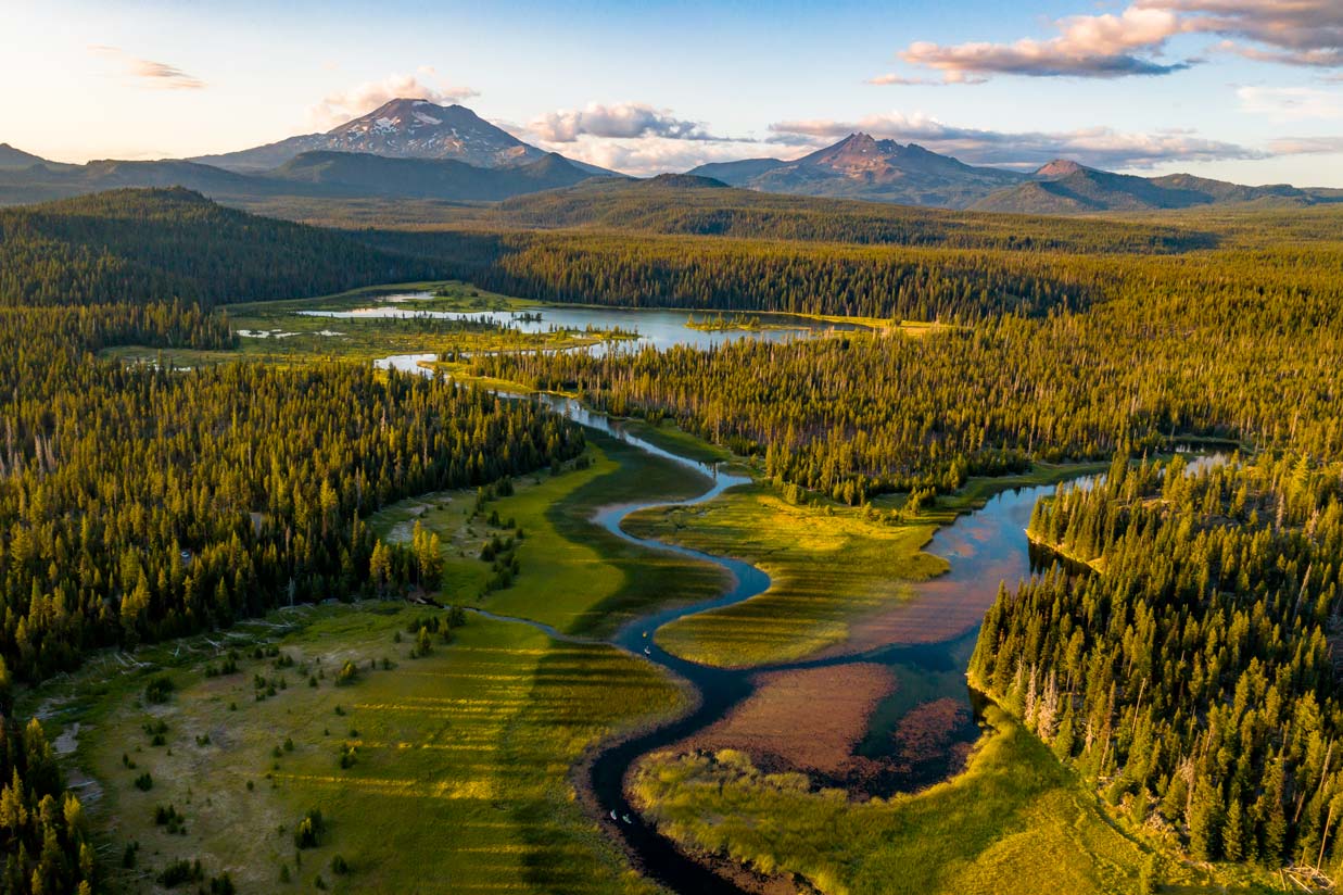
The Forest Service would log 4,928 acres of the Akawa Butte burn just north of Sisters, Oregon, about 12 million board feet of timber, after a seven-day comment window and with no objection process.
What’s at risk
The project covers 10,080 acres of the Akawa Butte Fire just north of Sisters. Timber harvest would run across 4,928 of them: 3,587 acres of commercial salvage and 1,341 acres along 36.8 miles of road, cut 150 feet deep on each side. Burned forest is habitat for woodpeckers, bluebirds and other cavity nesters, and the area includes Metolius mule deer winter range.
If this goes through
The district is aiming to sign a decision by October 1, 2026. Logging would use tracked harvesters and ground-based yarding, with 3.05 miles of temporary road and a half-acre landing for every 10 to 15 acres. Snag retention averages 3 to 4 per acre in the salvage units and there is none required along the roads. Because the project is filed under an emergency determination, nobody gets to file an objection before it is final.
Our plain-English read of the official notice ↗. Check it against the agency’s own words below.
6 holes in the agency’s own analysis
What the public could have raised, from the agency’s own document
- I oppose this action as proposed, and I ask the agency to weigh the specific harms below.
- The document states that about 12 million board feet of timber will be authorized and that commercial salvage covers 3,587 acres, yet no site-specific environmental analysis is provided for the Akawa Butte Fire area. The agency relies entirely on a national programmatic Post-Fire Recovery EA rather than conducting any project-level NEPA analysis of actual site conditions, fire severity, soils, hydrology, or species populations on this specific landscape. The Treatment Acres Table shows 10,080 total acres affected, with 28,655 overlapping activity acres, yet no effects analysis, no alternatives analysis, and no mitigation rationale tied to local conditions appears anywhere in this document. The agency should prepare a project-specific EA or EIS that analyzes the actual environmental consequences of this specific project on this specific landscape.
- The document exempts roadside hazard tree removal units entirely from snag retention requirements. PDC TES-15 states 'there are no retention requirements for roadside danger tree salvage,' yet roadside hazard mitigation covers 1,341 acres and 36.8 miles of open road. Cavity-nesting species and TES species that depend on snags are present in the fire area, as TES-14 and TES-15 acknowledge, but 1,341 acres of potential snag habitat gets zero retention standards with no analysis of cumulative snag loss across the project. The agency should analyze the cumulative effect of zero snag retention across all roadside units on cavity-nesting species populations and justify the blanket exemption or set minimum retention standards.
- The temporary road activity card shows that the checkbox for 'Installing drainage features such as culverts' is unchecked, and the checkbox for 'Restore natural drainage patterns and watershed function by removing culverts or drainage structures' is also unchecked, yet the project authorizes 3.05 miles of new temporary road construction in a post-fire watershed where PDC H-10d expressly requires minimizing erosive effects through proper design and construction. Leaving culverts and drainage restoration unchecked while operating in a hydrologically sensitive burned landscape is internally inconsistent. The agency should explain why drainage features are excluded from temporary road construction and removal on this project and analyze the erosion and sedimentation risk of that choice.
- PDC TES-9 requires maintaining mixed stand conditions in burned areas, including retaining a well-distributed diversity of patch sizes and burned conditions, to support TES species habitat needs. The proposed action removes trees up to 20 inches DBH across 3,587 acres of commercial salvage and 1,341 acres of roadside treatment using mechanical tracked harvesters and ground-based logging on 4,928 acres, yet the document contains no analysis of how patch diversity or structural heterogeneity will be maintained at any scale. No maps, no targets, and no monitoring requirements for patch retention appear anywhere in the document. The agency should provide a spatial analysis showing how the proposed harvest pattern maintains the diversity of patch sizes and burned conditions required by TES-9.
Show all 8 points from the document
- PDC H-10a requires that cumulative detrimental soil effects from project implementation must at a minimum not exceed conditions prior to the planned activity, and that 80 percent of each activity area must retain acceptable productivity potential. The project authorizes landings at a rate of one per 10 to 15 acres, averaging one-half acre each, across 4,928 harvest acres, which implies roughly 330 to 490 landings totaling 165 to 245 acres of concentrated disturbance, yet no soil productivity analysis, no pre-activity detrimental soil condition baseline, and no cumulative soil impact calculation appears in the document. The agency should provide a site-specific soils analysis demonstrating that the 80 percent productivity threshold will be met across the project area given the combined footprint of landings, skid trails, and temporary roads.
- The document states that the gray wolf is an ESA-listed endangered species subject to detailed denning-period PDCs under TES-19a and TES-19b, including a one-mile activity buffer around known dens from April 1 through July 15 and pre-project monitoring plans when the project occurs within an Area of Known Wolf Activity (AKWA) and the homesite is unknown. The project covers 10,080 acres and will operate year-round, yet the document contains no disclosure of whether the project area falls within an AKWA, whether any wolf monitoring plan has been developed, whether any dens or rendezvous sites are known or suspected nearby, or how the agency will ensure operations cease if a den is discovered. The agency should disclose the wolf presence determination for the project area, identify whether a pre-project monitoring plan has been developed as required by TES-19a, and explain how the one-mile…
- Say something only you can say. The law requires the agency to consider and respond to substantive comments, and specifics are what make a comment substantive.
Also on the record, from our reporting
- The comment window is seven days. The district ranger signed the comment letter on September 14, 2026, and it requires that all comments be submitted or postmarked by September 21, 2026. A standard Forest Service environmental assessment gets a 30-day comment period. (Akawa Butte Fire Recovery Public Comment Letter, Sisters Ranger District, September 14, 2026 ↗)
- There is no objection process. The comment letter says the project is authorized as a Forest Health and Fuels Emergency Situation Determination under USDA Secretarial Memo 1078-006 and section 40807 of the Infrastructure Investment and Jobs Act, so the environmental assessment and finding of no significant impact are not subject to pre-decisional review under 36 CFR Part 218. The same law, 16 U.S.C. 6592c, still requires the project to be consistent with the Deschutes forest plan and requires the agency to take into account the probable environmental consequences of the action. (Public Comment Letter, September 14, 2026; 16 U.S.C. 6592c ↗)
- The district told the public meeting on September 14 that it has a target of a decision authorizing the work by October 1, 2026, ten days after comments close, and that it is using the new national post-fire environmental assessment instead of a site-specific one. (Sisters Ranger District public meeting presentation, September 14, 2026 ↗)
- When the Forest Service announced the national Post-Fire Recovery environmental assessment, it wrote that the assessment will not authorize, fund, or carry out any site specific action, and that site specific considerations, including any needed supplemental analysis, would be provided in project-specific documentation. No project-specific effects analysis for Akawa Butte has been released for the public to comment on. (Federal Register, January 9, 2026, 91 FR 954 ↗)
- The project's public comment reading room is switched off, so nobody outside the district can see how many comments came in or what they said. Reading rooms are optional, and the same forest has one running right now for the Newberry Geothermal comment period it opened on September 17. (Forest Service comment system, checked September 20, 2026 ↗)
In the agency’s own words
The project proposes post-fire recovery activities within the footprint of the Akawa Butte Fire. The proposed treatments within the Akawa Butte Fire Recovery include commercial salvage, roadside danger tree removal and reforestation.
Did the agency answer?
6 issues are on this record. The agency has not published its decision document yet, so each one stays pending until the agency answers.
Issues on the record, awaiting the decision
- PendingThe document states that about 12 million board feet of timber will be authorized and that commercial salvage covers 3,587 acres, yet no site-specific environmental analysis is provided for the Akawa
The document states that about 12 million board feet of timber will be authorized and that commercial salvage covers 3,587 acres, yet no site-specific environmental analysis is provided for the Akawa Butte Fire area. The agency relies entirely on a national programmatic Post-Fire Recovery EA rather than conducting any project-level NEPA analysis of actual site conditions, fire severity, soils, hydrology, or species populations on this specific landscape. The Treatment Acres Table shows 10,080 total acres affected, with 28,655 overlapping activity acres, yet no effects analysis, no alternatives analysis, and no mitigation rationale tied to local conditions appears anywhere in this document. The agency should prepare a project-specific EA or EIS that analyzes the actual environmental consequences of this specific project on this specific landscape.
A hole PLAN found in the agency’s own analysis, quote verified against the document
- PendingThe document exempts roadside hazard tree removal units entirely from snag retention requirements.
The document exempts roadside hazard tree removal units entirely from snag retention requirements. PDC TES-15 states 'there are no retention requirements for roadside danger tree salvage,' yet roadside hazard mitigation covers 1,341 acres and 36.8 miles of open road. Cavity-nesting species and TES species that depend on snags are present in the fire area, as TES-14 and TES-15 acknowledge, but 1,341 acres of potential snag habitat gets zero retention standards with no analysis of cumulative snag loss across the project. The agency should analyze the cumulative effect of zero snag retention across all roadside units on cavity-nesting species populations and justify the blanket exemption or set minimum retention standards.
A hole PLAN found in the agency’s own analysis, quote verified against the document
- PendingThe temporary road activity card shows that the checkbox for 'Installing drainage features such as culverts' is unchecked, and the checkbox for 'Restore natural drainage patterns and watershed functio
The temporary road activity card shows that the checkbox for 'Installing drainage features such as culverts' is unchecked, and the checkbox for 'Restore natural drainage patterns and watershed function by removing culverts or drainage structures' is also unchecked, yet the project authorizes 3.05 miles of new temporary road construction in a post-fire watershed where PDC H-10d expressly requires minimizing erosive effects through proper design and construction. Leaving culverts and drainage restoration unchecked while operating in a hydrologically sensitive burned landscape is internally inconsistent. The agency should explain why drainage features are excluded from temporary road construction and removal on this project and analyze the erosion and sedimentation risk of that choice.
A hole PLAN found in the agency’s own analysis, quote verified against the document
- PendingPDC TES-9 requires maintaining mixed stand conditions in burned areas, including retaining a well-distributed diversity of patch sizes and burned conditions, to support TES species habitat needs.
PDC TES-9 requires maintaining mixed stand conditions in burned areas, including retaining a well-distributed diversity of patch sizes and burned conditions, to support TES species habitat needs. The proposed action removes trees up to 20 inches DBH across 3,587 acres of commercial salvage and 1,341 acres of roadside treatment using mechanical tracked harvesters and ground-based logging on 4,928 acres, yet the document contains no analysis of how patch diversity or structural heterogeneity will be maintained at any scale. No maps, no targets, and no monitoring requirements for patch retention appear anywhere in the document. The agency should provide a spatial analysis showing how the proposed harvest pattern maintains the diversity of patch sizes and burned conditions required by TES-9.
A hole PLAN found in the agency’s own analysis, quote verified against the document
- PendingPDC H-10a requires that cumulative detrimental soil effects from project implementation must at a minimum not exceed conditions prior to the planned activity, and that 80 percent of each activity area
PDC H-10a requires that cumulative detrimental soil effects from project implementation must at a minimum not exceed conditions prior to the planned activity, and that 80 percent of each activity area must retain acceptable productivity potential. The project authorizes landings at a rate of one per 10 to 15 acres, averaging one-half acre each, across 4,928 harvest acres, which implies roughly 330 to 490 landings totaling 165 to 245 acres of concentrated disturbance, yet no soil productivity analysis, no pre-activity detrimental soil condition baseline, and no cumulative soil impact calculation appears in the document. The agency should provide a site-specific soils analysis demonstrating that the 80 percent productivity threshold will be met across the project area given the combined footprint of landings, skid trails, and temporary roads.
A hole PLAN found in the agency’s own analysis, quote verified against the document
- PendingThe document states that the gray wolf is an ESA-listed endangered species subject to detailed denning-period PDCs under TES-19a and TES-19b, including a one-mile activity buffer around known dens fro
The document states that the gray wolf is an ESA-listed endangered species subject to detailed denning-period PDCs under TES-19a and TES-19b, including a one-mile activity buffer around known dens from April 1 through July 15 and pre-project monitoring plans when the project occurs within an Akwa area and the homesite is unknown. The project covers 10,080 acres and will operate year-round, yet the document contains no disclosure of whether the project area falls within an Akwa, whether any wolf monitoring plan has been developed, whether any dens or rendezvous sites are known or suspected nearby, or how the agency will ensure operations cease if a den is discovered. The agency should disclose the wolf presence determination for the project area, identify whether a pre-project monitoring plan has been developed as required by TES-19a, and explain how the one-mile buffer will be implemented if operations proceed during the April 1 to July 15 denning period.
A hole PLAN found in the agency’s own analysis, quote verified against the document
The reporting behind this
From More Than Just ParksAfter more than a decade chasing peak color across America, we built the foliage map we always wanted.
Another foreign mining company wants a piece of America’s public lands. This one comes with millions of gallons of groundwater pumping and radioactive radon.
The Forest Service is rushing a massive post-fire logging project through a seven-day public comment window. The deadline is tonight.
More actions that need you
Go deeper, free
See how your members of Congress vote on public lands
Every representative, graded on the votes that decide the fate of parks, forests, and refuges.
Open ↗The mapSee the places under active threat
A live map of the parks, monuments, and wild country in the crosshairs right now.
Open ↗A wrong fact, a dead link, a form that wouldn’t take your letter: one tap and it comes to the people who build PLAN, with this fight attached.
Know an open comment period we are missing, or spotted a wrong deadline? .