Yellowstone has more than 1,000 miles of trails spread across 2.2 million acres, and most folks never get more than a quarter mile from their car. That’s a mistake we’re here to fix.
We’ve spent years filming in Yellowstone in every season. These are the 15 hikes we’d actually send you on, with real distances, real elevation numbers, and honest opinions about which ones earn your limited vacation hours.

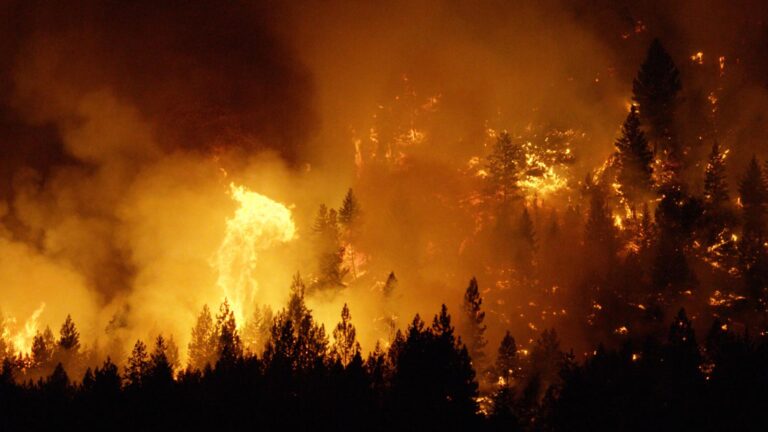
Trail Closures Update (June 2026): Biscuit Basin remains closed following the July 2024 hydrothermal explosion at Black Diamond Pool, and the Mystic Falls Trail is closed due to wildlife activity after a May 2026 bear incident. Both classics are off this list until they reopen. Check the park’s backcountry situation report before any hike, because Yellowstone closes trails on short notice for bears, snow, and geology that won’t sit still.
Yellowstone National Park Map
15 trails mapped — click a pin to learn more
Love Yellowstone? It's one of 109 threatened public lands destinations we're tracking. Get the free weekly briefing.
Yellowstone National Park at a Glance
4 alertsThe 15 Best Hikes in Yellowstone Compared
| Hike | Distance | Elevation Gain | Difficulty | Time |
|---|---|---|---|---|
| 1. Fairy Falls | 5.4 mi round trip | Under 200 ft | Easy | 2.5-3.5 hrs |
| 2. Mount Washburn (Dunraven Pass) | 6 mi round trip | About 1,400 ft | Strenuous | 3-5 hrs |
| 3. North Rim Trail | 3.8 mi one way | About 600 ft of ups and downs | Moderate | 2-3 hrs |
| 4. South Rim Trail to Point Sublime | 6.4 mi round trip | Rolling, under 500 ft | Moderate | 3 hrs |
| 5. Brink of the Lower Falls | 0.8 mi round trip | 600 ft down, then back up | Strenuous (briefly) | 45 min |
| 6. Grand Prismatic Overlook | 1.2 mi round trip | 105 ft | Easy | 45 min-1 hr |
| 7. Trout Lake | 1.2 mi lollipop | About 150 ft | Easy | 1 hr |
| 8. Bunsen Peak | 4.6 mi round trip | 1,300 ft | Moderately strenuous | 2-3 hrs |
| 9. Avalanche Peak | 4.2 mi round trip | 2,100 ft | Strenuous | 3-4 hrs |
| 10. Lone Star Geyser | 4.8 mi round trip | Nearly flat | Easy | 2-3 hrs |
| 11. Storm Point Loop | 2.3 mi loop | Minimal | Easy | 1-1.5 hrs |
| 12. Elephant Back Mountain | 3.5 mi lollipop | 800 ft | Moderate | 2 hrs |
| 13. Slough Creek (First Meadow) | 3.4 mi round trip | About 400 ft | Moderate | 1.5-2 hrs |
| 14. Lamar River Trail to Cache Creek | About 7 mi round trip | Gentle, under 400 ft | Moderate | 3-4 hrs |
| 15. Upper Geyser Basin to Morning Glory | About 3 mi round trip | Flat boardwalk | Easy | 1.5-2 hrs |
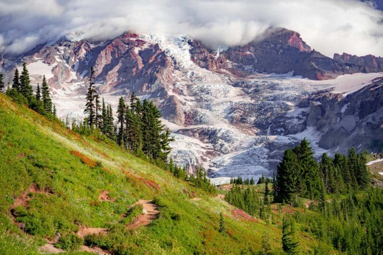
If You Only Do One Hike: Grand Prismatic Spring Overlook. Nothing prepares you for the colors. From the overlook, Grand Prismatic Spring looks like it was painted by someone who had never seen planet Earth, and the whole trail takes under an hour. If you have half a day instead, do Fairy Falls and get the overlook on the way.
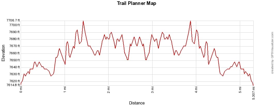
1. Fairy Falls Trail
- Distance: 5.4 miles round trip (6.7 with the geyser extension)
- Difficulty: Easy
- Elevation Gain: Under 200 feet
- Time Required: 2.5 to 3.5 hours
- Trailhead: Fairy Falls Parking Lot, 1 mile south of Midway Geyser Basin
The best hike in Yellowstone is also one of the easiest, which almost feels like cheating. The Fairy Falls Trail passes the Grand Prismatic Overlook spur in the first half mile, so you get the most famous view in the park as an appetizer.
Keep walking through the lodgepole pines and you reach Fairy Falls, a 200-foot ribbon of water dropping off the Madison Plateau. It’s nearly twice the height of Niagara and you might share it with a dozen people instead of a thousand.
Add the 0.6-mile extension to Spray and Imperial geysers if you have the legs. Imperial erupts frequently and you’ll likely have it to yourself. Note that this trailhead stays closed in early spring for bear management, typically opening in late May.
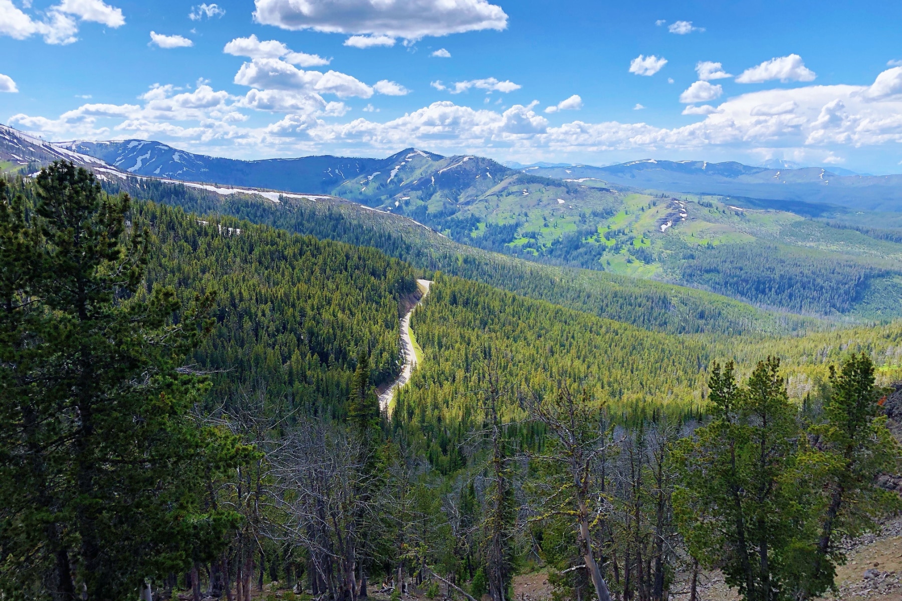
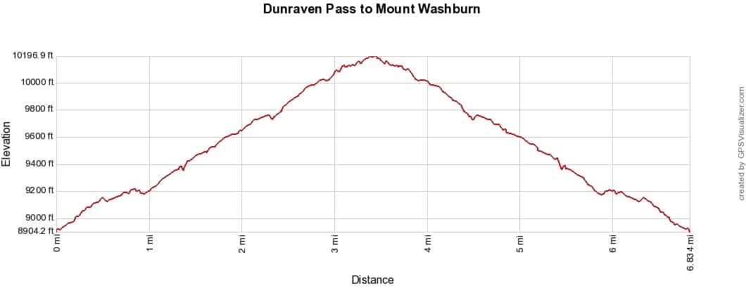
2. Mount Washburn via Dunraven Pass
- Distance: 6 miles round trip
- Difficulty: Strenuous
- Elevation Gain: About 1,400 feet to the 10,219-foot summit
- Time Required: 3 to 5 hours
- Trailhead: Dunraven Pass parking lot, 4.5 miles north of Canyon Junction
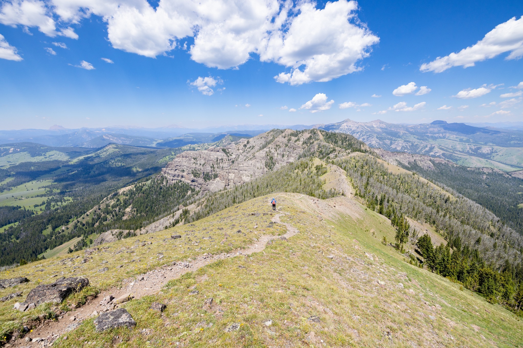
The best view in Yellowstone, full stop. On a clear day from the fire lookout on top of Mount Washburn you can see the Tetons, Yellowstone Lake, the Grand Canyon of the Yellowstone, and on exceptional days a horizon 50 miles out.
The grade is steady rather than brutal because the trail follows an old stagecoach road. Bighorn sheep work the slopes in summer, and July wildflowers up here are absurd.
Two warnings. You’re above treeline for the back half, so start early and bail if thunderheads build. And grizzlies feed heavily on this mountain in fall, which is why the park recommends groups of three or more with bear spray. As of early June 2026 the last mile still held firm snow, so pack accordingly in early season.
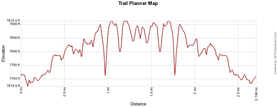
3. North Rim Trail
- Distance: 3.8 miles one way (hike any segment)
- Difficulty: Moderate
- Elevation Gain: About 600 feet of ups and downs
- Time Required: 2 to 3 hours
- Trailhead: Inspiration Point at the northeast end, or pick it up anywhere along the rim
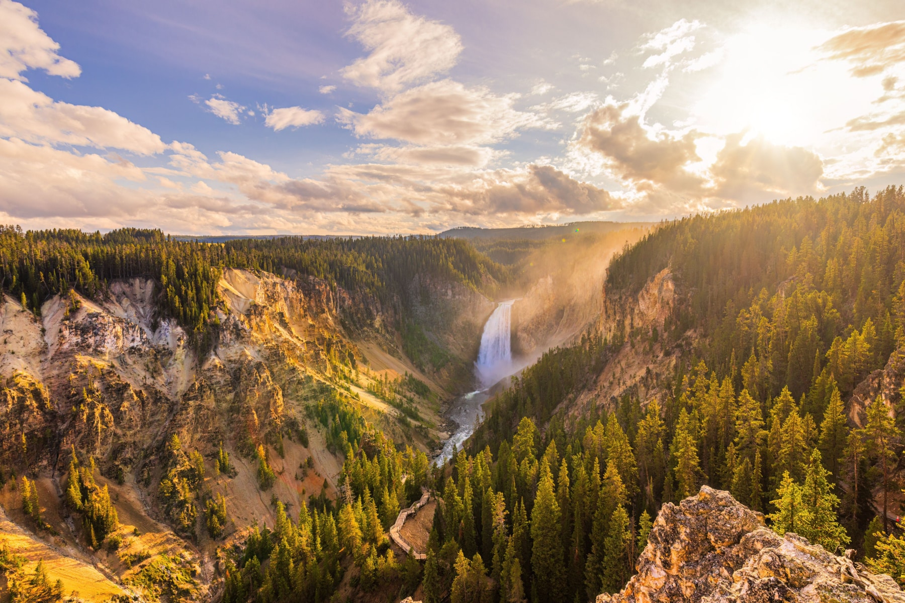
The North Rim Trail strings together the greatest hits of the Grand Canyon of the Yellowstone from Inspiration Point past Grand View to the Upper Falls. The canyon walls glow yellow and pink, hence the park’s name, and the 308-foot Lower Falls thunders below you the whole way.
Park at Inspiration Point and walk as far as your schedule allows. You hit Grand View Point after about 1.3 miles, and the spur down to the Brink of the Lower Falls comes at mile 2.5.
Because the trail parallels the rim drive, you can shuttle it with two cars or just turn around whenever. It’s the best effort-to-payoff ratio in the canyon area.
4. South Rim Trail to Artist Point and Point Sublime
- Distance: 6.4 miles round trip from Chittenden Bridge (3.2 if you start at Artist Point)
- Difficulty: Moderate
- Elevation Gain: Rolling, under 500 feet
- Time Required: 3 hours
- Trailhead: Wapiti Lake Trailhead at Chittenden Bridge, or Artist Point parking
Artist Point is the postcard. Thomas Moran’s paintings from this canyon helped convince Congress to create the park in 1872, and when you stand here you understand why the argument worked.
Here’s the move everybody misses. Keep walking past Artist Point. The crowd evaporates within 200 yards, and the 1.3 miles out to Point Sublime serve up canyon views that are arguably better, with hoodoos and sheer drops and exactly zero tour buses.
Mind your footing near the edges. The rim is crumbly volcanic rock, and the railings end where the crowds do.
5. Brink of the Lower Falls Trail
- Distance: 0.8 miles round trip
- Difficulty: Strenuous on the way back up
- Elevation Change: 600 feet down 10 switchbacks, then 600 feet back up
- Time Required: 45 minutes
- Trailhead: Brink of Lower Falls parking area, North Rim Drive
This trail puts you at the lip of the tallest waterfall in the park, where the Yellowstone River drops 308 feet, nearly twice Niagara, and you feel the rumble in your sternum.
It’s a little tougher than it looks on paper. The trail loses 600 feet in less than half a mile, and every foot of it waits for you on the return. Take it slow at 7,500 feet of altitude and let your knees forgive you later.
This might be the best 45 minutes you can spend in Yellowstone. Closed in winter, and arrive before 9 am in summer if you want a parking spot.
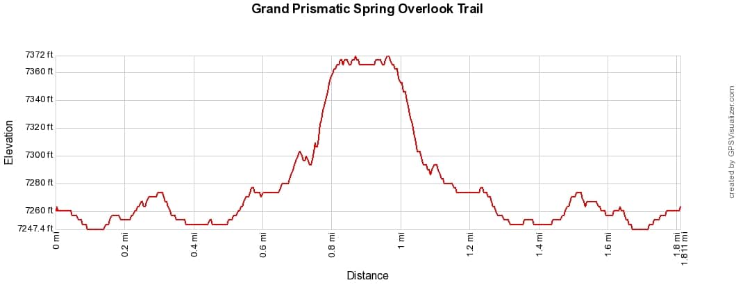
6. Grand Prismatic Overlook Trail

- Distance: 1.2 miles round trip
- Difficulty: Easy
- Elevation Gain: 105 feet
- Time Required: 45 minutes to 1 hour
- Trailhead: Fairy Falls Parking Lot, 1 mile south of Midway Geyser Basin
From the boardwalk at Midway Geyser Basin, Grand Prismatic Spring is steam and hints of color. From this overlook 105 feet up the hillside, it’s the full rainbow, a hot spring wider than a football field ringed in orange, yellow, and impossible blue.
The colors come from heat-loving bacteria sorted into rings by temperature, which is the kind of fact that’s fun to deploy while everyone stands there speechless.
Go mid-morning. Too early and the spring hides under its own steam; midday and you fight the whole park for parking. The overlook trail is open even while areas west of it close seasonally, but check conditions anyway.
7. Trout Lake Trail
- Distance: 1.2-mile lollipop loop
- Difficulty: Easy (one short steep pitch)
- Elevation Gain: About 150 feet
- Time Required: 1 hour
- Trailhead: Pullout 1.5 miles south of Pebble Creek Campground, Northeast Entrance Road
Trout Lake is the most underrated hour in Yellowstone. A short climb through Douglas-fir delivers you to a quiet lake backed by Absaroka peaks, with wildflowers in summer and otters working the shoreline if your timing is good.
In early summer you can watch cutthroat trout stacking up in the inlet stream to spawn, an arm’s length away. Ospreys know this too, so keep your eyes up.
If you want to fish, remember Yellowstone requires its own park fishing permit. A Montana, Idaho, or Wyoming license will not suffice. Bears use this area heavily in spring, so make noise on the blind corners.
8. Bunsen Peak Trail
- Distance: 4.6 miles round trip
- Difficulty: Moderately strenuous
- Elevation Gain: 1,300 feet
- Time Required: 2 to 3 hours
- Trailhead: Gravel lot 5 miles south of Mammoth Hot Springs, just south of Golden Gate
Bunsen Peak is the entry-level summit in Yellowstone, and we mean that as a compliment. You get a real mountaintop, with views over Mammoth, the Gallatin Range, and Swan Lake Flat, for half the effort Avalanche Peak demands.
The climb is steady but never desperate, gaining 1,300 feet in just over two miles. The small parking lot fills by mid-morning in summer, which is your cue to start at 8.
Got extra legs? From the same trailhead you can take the old Bunsen Peak Road toward Osprey Falls, a 150-foot waterfall at the bottom of Sheepeater Canyon. That detour turns the day into 8-plus miles, so save it for when you mean it.
9. Avalanche Peak Trail
- Distance: 4.2 miles round trip
- Difficulty: Strenuous
- Elevation Gain: 2,100 feet
- Time Required: 3 to 4 hours
- Trailhead: Eleanor Lake pullout, 19 miles east of Fishing Bridge Junction
The hardest hike on this list, and the one serious hikers will love most. Avalanche Peak gains 2,100 feet in 2.1 miles, which is a staircase with scenery.
The summit view reaches across Yellowstone Lake to the Absarokas and, on clear days, the Tetons. The last stretch crosses open talus above treeline, so weather matters here more than fitness.
Timing is everything. Snow buries the route until early July, and the park advises skipping it in September and October when grizzlies feed on whitebark pine nuts up high. That leaves a window of about eight good weeks. Use one of them.
10. Lone Star Geyser Trail
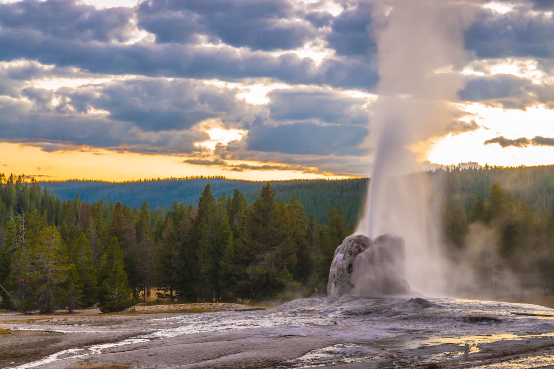
- Distance: 4.8 miles round trip
- Difficulty: Easy
- Elevation Gain: Nearly flat
- Time Required: 2 to 3 hours (time it to the eruption)
- Trailhead: 3.5 miles south of Old Faithful, past the Kepler Cascades parking lot
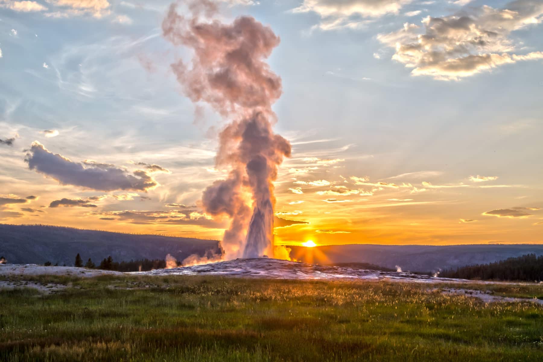
Here’s the math that makes Lone Star our favorite geyser experience in the park. Old Faithful erupts for a crowd of 2,000. Lone Star erupts roughly every three hours for whoever bothered to walk 2.4 miles up an old paved service road along the Firehole River. Sometimes that’s six people.
The 12-foot cone is striking even between eruptions, and when it goes, it can throw water 30 to 45 feet for several minutes. Check the logbook at the geyser for the last eruption time and pack a lunch if you need to wait.
The flat, paved grade makes this one of the few Yellowstone trails you can also bike, though you’ll walk the final few hundred feet. Heads up that bear activity warnings are posted for the trails branching off this area in 2026.
11. Storm Point Loop
- Distance: 2.3-mile loop
- Difficulty: Easy
- Elevation Gain: Minimal
- Time Required: 1 to 1.5 hours
- Trailhead: Indian Pond pullout, 3 miles east of Fishing Bridge Visitor Center
Storm Point gives you Yellowstone Lake the way it deserves to be seen, from a windswept bluff with waves breaking below and the Absarokas across the water. The lake sits at 7,733 feet, and the “storm” in the name is honest advertising on breezy afternoons.
The loop passes Indian Pond, cruises the shoreline, and returns through lodgepole forest. The colony of yellow-bellied marmots living in the rocks at the point will happily pose for photos.
This trail closes frequently in late spring and early summer for bear activity, so check at the Fishing Bridge Visitor Center before driving out.
12. Elephant Back Mountain Trail
- Distance: 3.5-mile lollipop loop
- Difficulty: Moderate
- Elevation Gain: 800 feet
- Time Required: 2 hours
- Trailhead: Pullout 1 mile south of Fishing Bridge Junction, near Lake Village
Elephant Back is the overlook hike for the Lake region. After 0.8 miles the trail splits into a loop, and either fork climbs through dense lodgepole to a panorama of Yellowstone Lake, the largest high-elevation lake in North America, with the Absarokas stacked behind it.
The 800-foot climb packs into about a mile and a half, enough to earn the view without wrecking your afternoon. Take the left fork up for the shorter push and descend the long way.
Staying at Lake Lodge or Lake Hotel? This trailhead is walking distance, which makes it the best sunrise option on the lake.
13. Slough Creek Trail to the First Meadow
- Distance: 3.4 miles round trip (8.6 to the second meadow)
- Difficulty: Moderate
- Elevation Gain: About 400 feet, front-loaded in the first mile
- Time Required: 1.5 to 2 hours
- Trailhead: Slough Creek Campground road, off the Northeast Entrance Road
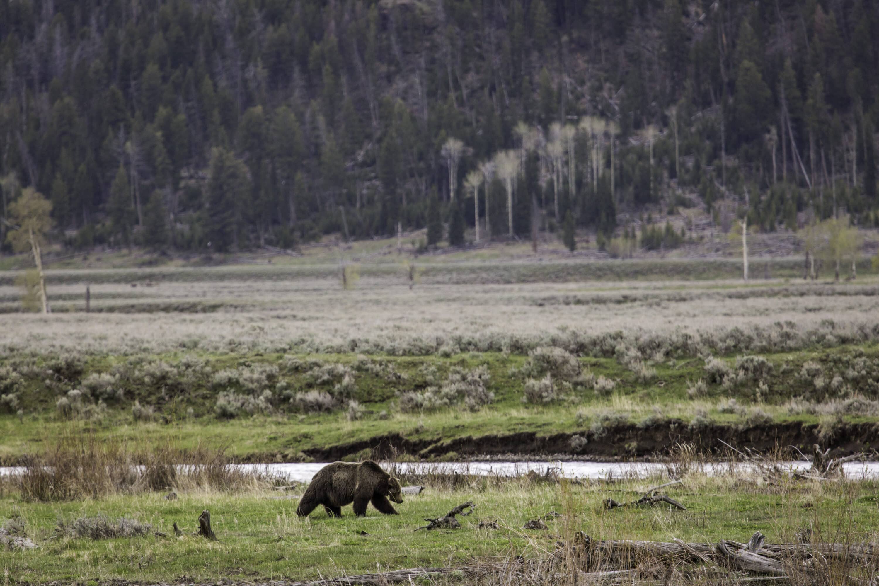
Slough Creek follows a historic wagon route over a forested hump and drops you into a meadow that looks like the West before anybody fenced it. Trout rise in the creek, bison graze the far bank, and wolves from the northern range pass through often enough to keep things interesting.
The first mile climbs about 400 feet and then gives most of it back, which surprises folks expecting a flat meadow stroll. After that it’s all reward.
Anglers consider this one of the best cutthroat streams in America, so expect company with fly rods. Continue another 2.6 miles to the second meadow if solitude is the goal.
14. Lamar River Trail to Cache Creek
- Distance: About 7 miles round trip to Cache Creek
- Difficulty: Moderate (distance, not grade)
- Elevation Gain: Gentle, under 400 feet
- Time Required: 3 to 4 hours
- Trailhead: Lamar River (Soda Butte) Trailhead, Northeast Entrance Road
Lamar Valley gets called the American Serengeti, and this is the trail that lets you walk into it instead of watching from a roadside scope line. Bison herds, pronghorn, badgers, and the occasional wolf or grizzly at a distance that demands respect.
The walking is easy across open sagebrush flats, with the turnaround at Cache Creek’s drainage about 3.5 miles in. The full Lamar River Trail runs 33 miles into the backcountry, so day hikers turn around whenever the valley has made its point.
This is open country with zero shade and resident wildlife in every direction. Carry bear spray, give bison 25 yards minimum, and go early when the animals are moving.
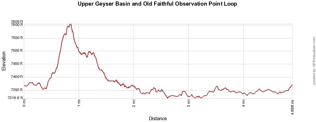
15. Upper Geyser Basin to Morning Glory Pool
- Distance: About 3 miles round trip
- Difficulty: Easy
- Elevation Gain: Flat boardwalk and paved path
- Time Required: 1.5 to 2 hours
- Trailhead: Old Faithful Visitor Education Center
Calling a boardwalk one of the best hikes in Yellowstone feels like a stretch until you remember it crosses the densest concentration of geysers on Earth. Old Faithful is the opening act. Castle, Grotto, Riverside, and finally Morning Glory Pool round out a lineup no other square mile on the planet can match.
The walk from the visitor center to Morning Glory runs about a mile and a half each way. Grab predicted eruption times at the visitor center first and you can time Riverside or Castle going off as you pass.
Go at sunrise or after 6 pm. The basin at golden hour with the crowds gone is a different park, and the bison who wander between the geysers seem to agree.
What About Mystic Falls and Biscuit Basin?
Both belong on this list in a normal year, and this isn’t a normal year. Biscuit Basin has been closed since a hydrothermal explosion at Black Diamond Pool blew rocks and boiling water across the boardwalk in July 2024, and the pool has kept erupting on and off since. Mystic Falls Trail closed in May 2026 after a bear injured two hikers near the falls.
We’ll restore both to the rankings when the Park Service reopens them. Until then, respect the closures. The fines are real and so are the hazards.
Hiking Safety in Yellowstone
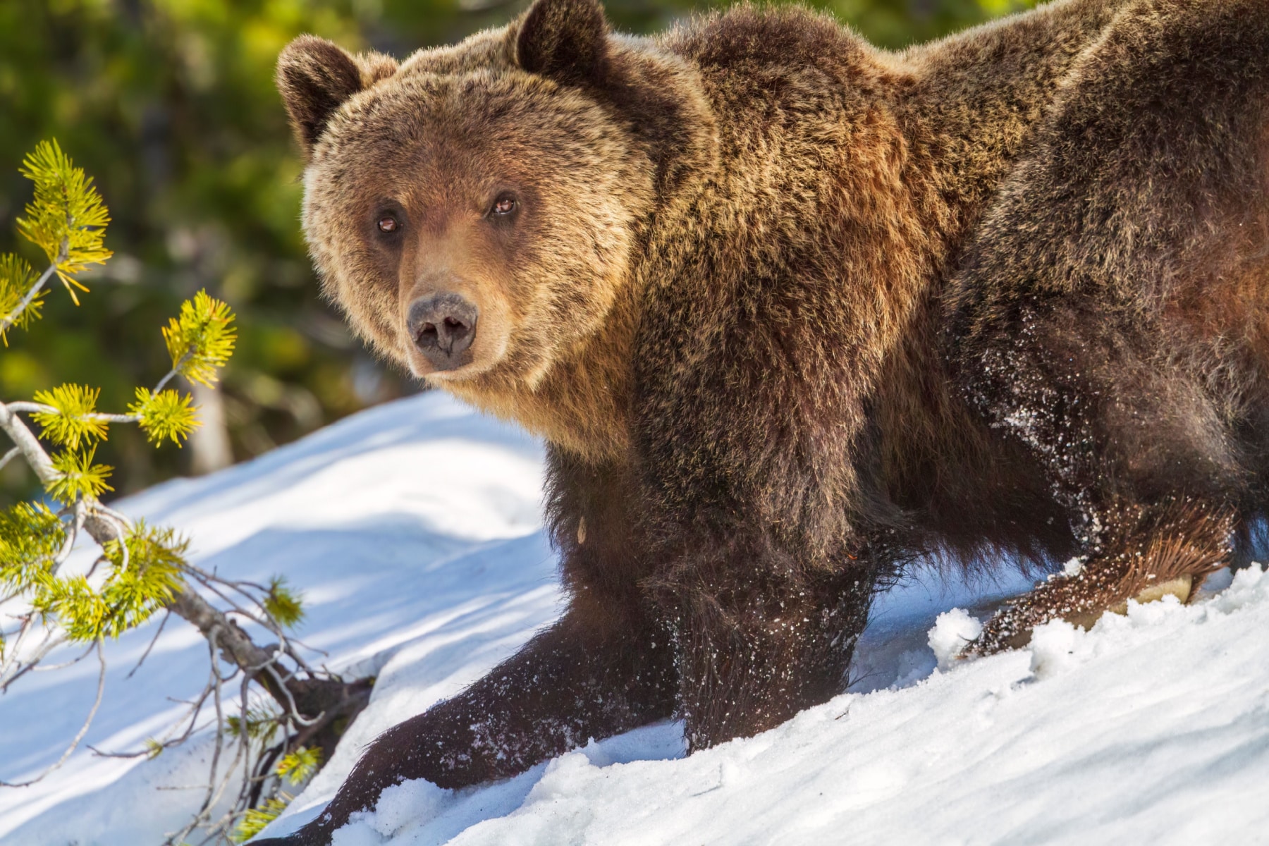
Every trail above runs through grizzly country. Carry bear spray where you can reach it in two seconds, hike in groups of three or more, and make noise in thick forest and near streams. Stay on boardwalks in thermal areas, because the crust is thin and the water below it is literally boiling.
Most of the park sits between 7,000 and 8,500 feet. Afternoon thunderstorms build fast in summer, so summit early and carry layers year-round.
What trail did we miss? With 2.2 million acres, there are always underrated spots we haven’t covered. Tell us your favorite Yellowstone hike in the comments and we’ll check it out on our next trip.
FAQ – Best Hikes in Yellowstone
On this list, Avalanche Peak, which gains 2,100 feet in 2.1 miles and crosses open talus above treeline. Mount Washburn is longer but far more forgiving. Both cross serious grizzly habitat in fall, when the park advises skipping Avalanche Peak entirely.
Hiking alone is strongly discouraged. The park recommends groups of three or more. Yellowstone reports that 91% of people injured by bears in the park were hiking alone or in groups of two. If you are traveling solo, pick the busier trails and keep pace within sight of other groups.
Yes. Bring your own bear spray or buy a canister in the park, and wear it somewhere you can reach instantly. A bear will not wait while you dig through your backpack. Use bear-proof food containers to lower the risk in the first place.
No. Biscuit Basin has been closed since the July 2024 hydrothermal explosion at Black Diamond Pool, and Mystic Falls Trail closed in May 2026 due to bear activity. Check the park’s current conditions page before your trip, because Yellowstone updates closures weekly.
Summary of the Best Hikes in Yellowstone
- Fairy Falls Trail
- Mount Washburn via Dunraven Pass
- North Rim Trail
- South Rim Trail to Artist Point and Point Sublime
- Brink of the Lower Falls Trail
- Grand Prismatic Overlook Trail
- Trout Lake Trail
- Bunsen Peak Trail
- Avalanche Peak Trail
- Lone Star Geyser Trail
- Storm Point Loop
- Elephant Back Mountain Trail
- Slough Creek Trail (First Meadow)
- Lamar River Trail to Cache Creek
- Upper Geyser Basin to Morning Glory Pool
Why Listen to Us About the Best Hikes in Yellowstone?
We’re Will and Jim Pattiz, the Parks Brothers. We’ve spent our adult lives filming America’s national parks, including Yellowstone in every season, and we’ve worked with the National Park Service, the Department of Interior, and the U.S. Forest Service creating films on important places and issues. These rankings come from boots on these specific trails, cross-checked against current NPS trail data.
Helpful Related Links
Yellowstone’s Secrets Revealed: 18 (Fascinating) Yellowstone National Park Facts You Probably Didn’t Realize
Things to Do Yellowstone: 15 Best Things to Do in Yellowstone National Park
Yellowstone in the Fall: Our Guide to Visiting Yellowstone in the Fall
Best Airports Near Yellowstone: The Best Airports Near Yellowstone National Park
The Wyoming National Parks: 10 Epic Wyoming National Parks (+ Photos)
Mount Rushmore to Yellowstone: Driving Mount Rushmore to Yellowstone National Park Road Trip
Grand Teton Hikes: 18 Epic Grand Teton National Park Hikes (Photos + Guide)
Grand Teton Guide: Grand Teton National Park Ultimate Guide
Grand Teton Maps: The Best Maps for Grand Teton National Park
What to Bring to Yellowstone
Gear we recommend for Yellowstone. Affiliate links support our work at no cost to you.
Affiliate disclosure: Some links on this page earn us a small commission at no extra cost to you. We only recommend gear we actually use.