

Arizona has three true national parks, Grand Canyon, Saguaro, and Petrified Forest, plus one of the deepest rosters of National Park Service sites in the country. Counted honestly, the state holds 25 National Park Service units: 3 national parks, 13 national monuments, 1 national historical park, 2 national historic sites, 1 national memorial, 2 national recreation areas, and 3 national historic trails.
A word on accuracy, because Arizona is where these lists almost always inflate. Several famous “national monuments” here, Vermilion Cliffs, Agua Fria, Sonoran Desert, and Ironwood Forest, are run by the Bureau of Land Management, not the National Park Service, so they are not on this list. Neither is Hohokam Pima National Monument, which is closed to the public on tribal land. Everything below is a genuine NPS unit, labeled by its real designation.

Arizona National Park Service Sites At A Glance
| Site | Federal Designation | Region |
|---|---|---|
| Grand Canyon National Park | National Park | North |
| Saguaro National Park | National Park | South (Tucson) |
| Petrified Forest National Park | National Park | East (Holbrook) |
| Canyon de Chelly National Monument | National Monument | Northeast (Chinle) |
| Chiricahua National Monument | National Monument | Southeast (Willcox) |
| Organ Pipe Cactus National Monument | National Monument | South (Ajo) |
| Wupatki National Monument | National Monument | North (Flagstaff) |
| Sunset Crater Volcano National Monument | National Monument | North (Flagstaff) |
| Walnut Canyon National Monument | National Monument | North (Flagstaff) |
| Montezuma Castle National Monument | National Monument | Central (Camp Verde) |
| Tonto National Monument | National Monument | Central (Roosevelt) |
| Navajo National Monument | National Monument | Northeast (Shonto) |
| Tuzigoot National Monument | National Monument | Central (Clarkdale) |
| Casa Grande Ruins National Monument | National Monument | Central (Coolidge) |
| Pipe Spring National Monument | National Monument | Arizona Strip (Fredonia) |
| Grand Canyon-Parashant National Monument | National Monument (NPS / BLM) | Arizona Strip |
| Tumacácori National Historical Park | National Historical Park | South (Tubac) |
| Fort Bowie National Historic Site | National Historic Site | Southeast (Bowie) |
| Hubbell Trading Post National Historic Site | National Historic Site | Northeast (Ganado) |
| Coronado National Memorial | National Memorial | South (Hereford) |
| Glen Canyon National Recreation Area | National Recreation Area | North (Page) |
| Lake Mead National Recreation Area | National Recreation Area | Northwest (Mohave) |
| Juan Bautista de Anza NHT | National Historic Trail | South corridor |
| Old Spanish National Historic Trail | National Historic Trail | Arizona Strip corridor |
| Butterfield Overland National Historic Trail | National Historic Trail | South corridor |
1. Grand Canyon National Park
The first of three true national parks in Arizona, and one of the great landscapes on Earth: a mile-deep, 277-mile-long gorge carved by the Colorado River. The South Rim is open year-round with the most services; the North Rim is higher, cooler, and closed in winter.
Walk a stretch of the Bright Angel or South Kaibab trail below the rim for a real sense of scale, ride the free shuttles along Hermit Road, and stay for sunset at Hopi or Mather Point. Even a single overlook day is worth the trip.
117 public lands destinations are under threat. Get the free briefing that 27,000+ people use to stay informed and take action.

Grand Canyon Facts | Best Hikes | Best Time To Visit
2. Saguaro National Park
The second true national park, split into two districts that bracket Tucson and protect dense forests of the giant saguaro cactus, the iconic symbol of the American Southwest. The Rincon Mountain District east of town and the Tucson Mountain District west of town each has its own scenic loop drive.
Drive the Cactus Forest or Bajada loop, hike among saguaros that can top 40 feet and live 150 years, and go at dawn or dusk to beat the desert heat. Late spring brings the creamy saguaro blossoms.

Saguaro Facts | Best Hikes | Things To Do
3. Petrified Forest National Park
The third true national park, straddling I-40 in the high desert of eastern Arizona. It protects one of the world’s largest concentrations of petrified wood, fossilized logs roughly 225 million years old, alongside the banded badlands of the Painted Desert.
The 28-mile park road links every highlight, from the Painted Desert overlooks to the Crystal Forest and Blue Mesa trails. It is easy to see in half a day as a stop on a longer drive, and old Route 66 runs right through it.

Petrified Forest Facts | Things To Do
4. Canyon de Chelly National Monument
A national monument on Navajo Nation trust land, unusual in that families still live and farm on the canyon floor. Sheer red walls shelter ancient cliff dwellings and the dramatic 800-foot Spider Rock spire.
You can drive the free North and South Rim roads to overlooks on your own, but to go down into the canyon you must hire an authorized Navajo guide, with one exception, the White House Trail. Hiring a guide is the right way to experience it anyway.

5. Chiricahua National Monument
A national monument in the southeast corner, famous for its forest of balanced rocks and towering rhyolite spires, a place the Apache called the land of standing-up rocks. A bill to redesignate it as Arizona’s fourth national park passed the U.S. House in March 2026 but has not become law, so for now it remains a monument.
The scenic drive climbs to Massai Point, and the Echo Canyon and Heart of Rocks trails wind among the hoodoos. It is remote and quiet, well worth the detour from Willcox.
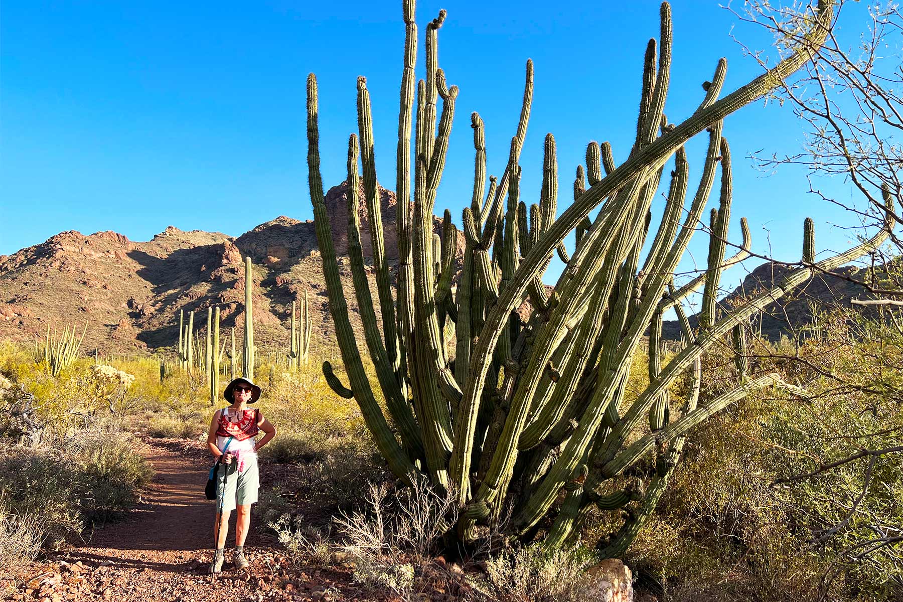
6. Organ Pipe Cactus National Monument
A national monument and international biosphere reserve on the Mexican border, the only place in the United States where the organ pipe cactus grows wild in any number.
Drive the Ajo Mountain Loop, hike among multi-armed cacti, and stay for some of the darkest night skies in the system. Go in the cooler months; summer here is extreme.
7. Wupatki National Monument
A national monument north of Flagstaff preserving red-sandstone pueblos built by Ancestral Puebloan farmers in the 1100s. The largest, Wupatki Pueblo, once stood several stories tall and even had a ceremonial ball court.
A 35-mile loop road links Wupatki with neighboring Sunset Crater Volcano, so plan to see both together. Short trails lead right up to the ruins.
8. Sunset Crater Volcano National Monument
A national monument protecting a 1,000-foot cinder cone that erupted around 1085 CE, the youngest volcano in the region. Its rim glows with red and orange oxidized cinders, which gave it the name.
The Lava Flow Trail loops across the hardened black flows at the cone’s base. Paired with Wupatki on the same loop drive, it makes an easy half-day from Flagstaff.

9. Walnut Canyon National Monument
A national monument just east of Flagstaff where the Sinagua people built cliff dwellings into the limestone ledges of a deep, forested canyon around 700 years ago.
The Island Trail drops 240 steps into the canyon and passes 25 cliff rooms you can look right into. It is short but steep, and at 7,000 feet you will feel the elevation.

10. Montezuma Castle National Monument
A national monument near Camp Verde protecting one of the best-preserved cliff dwellings in North America, a five-story, 20-room Sinagua structure tucked into a limestone cliff about 90 feet up. The Aztec emperor Montezuma had nothing to do with it; early settlers simply misnamed it.
A flat third-mile loop along Beaver Creek gives the classic view from below. The detached Montezuma Well unit, a limestone sinkhole spring, is included and worth the short extra drive.
11. Tonto National Monument
A national monument above Roosevelt Lake preserving Salado-style cliff dwellings built in the 1300s overlooking the Tonto Basin.
A paved half-mile trail climbs to the Lower Cliff Dwelling; the Upper Dwelling is reachable only by guided hike in the cooler season. The views over the lake and Sonoran Desert are the bonus.

12. Navajo National Monument
A national monument on the Navajo Nation preserving three of the largest and best-preserved Ancestral Puebloan cliff dwellings in the Southwest: Betatakin, Keet Seel, and Inscription House.
The easy Sandal Trail leads to an overlook of Betatakin. Reaching the dwellings themselves takes a strenuous ranger-led hike, and Keet Seel requires a permit and an overnight, but the rim views are free and rewarding on their own.

13. Tuzigoot National Monument
A national monument near Clarkdale preserving a hilltop Sinagua pueblo of 110 rooms that crowned the Verde Valley between roughly 1000 and 1400 CE.
A short paved loop climbs through the restored masonry to a rooftop view over the valley and the Verde River wetlands. Pair it with Montezuma Castle for a full Verde Valley day.

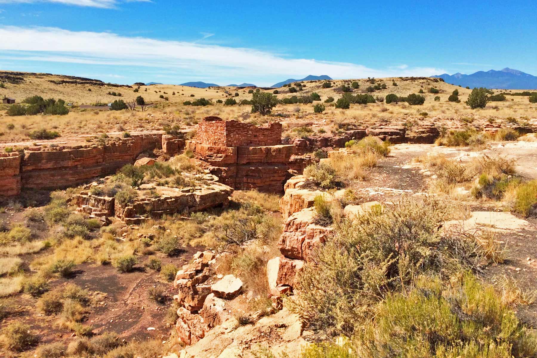
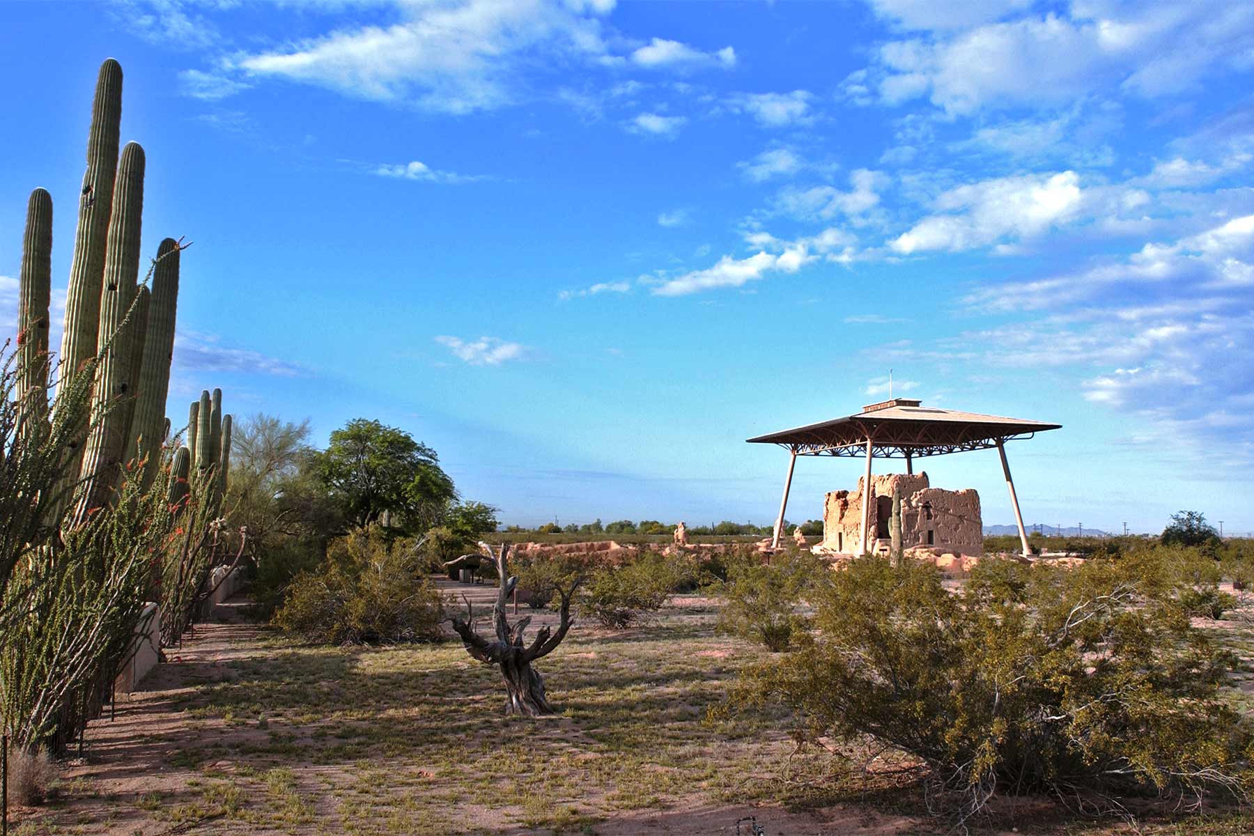
14. Casa Grande Ruins National Monument
A national monument in Coolidge protecting one of the largest known structures the ancient Sonoran Desert people ever built, a four-story earthen Great House raised around 1350 CE. It was the country’s first archaeological preserve.
A modern steel canopy shelters the fragile caliche walls. A short self-guided walk and the visitor center exhibits explain a culture whose canal engineering still shapes the region.
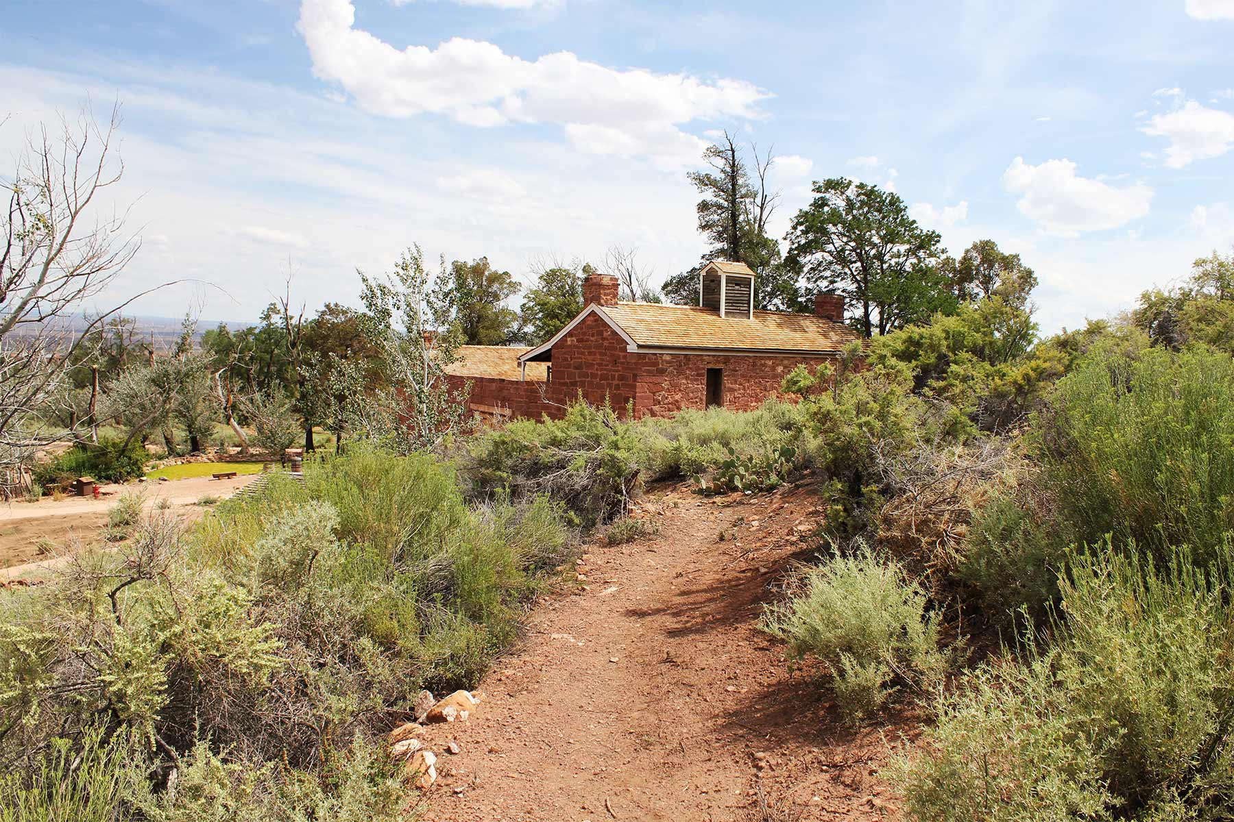
15. Pipe Spring National Monument
A national monument on the remote Arizona Strip, set on Kaibab Paiute land, built around a rare desert spring. A fortified 1870s Mormon ranch house, Winsor Castle, tells the layered story of Paiute, settler, and rancher life around that precious water.
Ranger-guided tours of the fort and a short trail to the spring make a good stop between Zion and the North Rim. It is far from anything, so plan fuel.
16. Grand Canyon-Parashant National Monument
A vast, roadless national monument on the Arizona Strip, jointly managed by the National Park Service and the Bureau of Land Management. It protects more than a million acres of canyon and plateau north of the Grand Canyon.
There are no paved roads, no visitor center, and no services inside it. This is true backcountry for high-clearance, self-sufficient travelers only, but the solitude is the point.
17. Tumacácori National Historical Park
A national historical park south of Tucson preserving the ruins of three Spanish colonial mission communities, the oldest founded by Father Kino in 1691. The graceful adobe church of Mission San José de Tumacácori anchors the main site.
Walk the grounds, the church, and the orchard, and time a visit for the fall craft fair if you can. It pairs naturally with the Juan Bautista de Anza trail that begins nearby.
18. Fort Bowie National Historic Site
A national historic site in the southeast preserving the ruins of a frontier fort central to the long conflict with the Chiricahua Apache and the campaigns against Geronimo through Apache Pass.
Reaching it takes a 1.5-mile walk in from the trailhead, which keeps it quiet and atmospheric. The trail passes the Butterfield stage station, a cemetery, and Apache Spring on the way to the fort ruins.

19. Hubbell Trading Post National Historic Site
A national historic site in Ganado on the Navajo Nation, the oldest continuously operating trading post on the reservation, in business since 1878.
It is still a working store. You can buy authentic Navajo rugs and silverwork, tour the Hubbell home, and watch weaving demonstrations. It is a living piece of history, not a static ruin.
20. Coronado National Memorial
A national memorial on the Mexican border south of Sierra Vista, commemorating the 1540 expedition of Francisco Vázquez de Coronado, the first major European entry into the Southwest.
Drive up to Montezuma Pass for sweeping views into Mexico and the San Pedro Valley, hike a stretch of the Arizona Trail, or tour the Coronado Cave with a free permit. It is a quiet, scenic stop.

21. Glen Canyon National Recreation Area
A national recreation area centered on Lake Powell, the reservoir behind Glen Canyon Dam, spanning northern Arizona and southern Utah. Red-rock canyons, slickrock, and 1.25 million acres surround the water.
Boat or houseboat on Lake Powell, visit Lees Ferry, the launch point for Grand Canyon river trips, and detour to nearby Horseshoe Bend. Drought has dropped lake levels in recent years, so check current conditions for ramps.

22. Lake Mead National Recreation Area
A national recreation area spanning the Arizona-Nevada line around Lake Mead and Lake Mohave, the reservoirs of Hoover and Davis dams on the Colorado River. The Arizona side runs through Mohave County.
It is built for water: boating, fishing, swimming, and paddling, plus desert hiking and scenic drives. As with Lake Powell, prolonged drought has lowered the lake, so check access before you go.
23. Juan Bautista de Anza National Historic Trail
The first of three national historic trails that cross Arizona. These are commemorative corridors administered by the NPS, not single gated parks, so you follow them through markers and interpreted segments.
This trail traces the 1775 to 1776 route Juan Bautista de Anza led from Nogales, Arizona, all the way to San Francisco to found the Spanish colony there. It begins near Tumacácori.
24. Old Spanish National Historic Trail
A national historic trail marking the trade route that once linked Santa Fe to Los Angeles. In Arizona it crosses the remote northern Strip, jointly administered by the NPS and the Bureau of Land Management.
Like the other trails, you experience it through markers and access points rather than a single entrance. Treat it as context for the wider Southwest road network.
25. Butterfield Overland National Historic Trail
The newest national historic trail on this list, added to the National Trails System in January 2023. It commemorates the 1858 to 1861 Butterfield Overland Mail route, the first regular overland stage line to California.
The route crosses southern Arizona through Pima County and past Apache Pass near Fort Bowie. Interpretive development is ongoing, so for now this one is more historical corridor than finished facility.
Planning Your Arizona Trip
Cluster by region. Northern Arizona built around Flagstaff and Page gives you Grand Canyon, the Wupatki and Sunset Crater loop, Walnut Canyon, and Glen Canyon. Central Arizona covers the Verde Valley pair of Montezuma Castle and Tuzigoot, plus Tonto and Casa Grande between Phoenix and the lakes. Southern Arizona around Tucson holds Saguaro, Tumacácori, Coronado, Chiricahua, Fort Bowie, and Organ Pipe. The remote Arizona Strip and Navajo Nation hold Pipe Spring, Parashant, Canyon de Chelly, Navajo Monument, and Hubbell Trading Post.
Fall through spring is ideal across most of the state; the southern desert is brutal in summer, while the high country around Flagstaff and the North Rim is pleasant then and snowbound in winter. The three national parks charge entrance fees and use shuttle or reservation systems in peak season; many monuments are free. On the Navajo Nation, respect local guidelines and hire authorized guides where required.
Parks Near Phoenix | Parks Near Tucson | Arizona Landmarks
Bottom line: Arizona holds three true national parks and 22 more National Park Service units, from a mile-deep canyon to thousand-year-old cliff dwellings. Counted honestly, it is one of the richest NPS states in the country.


