
High threat to public landsFiled 21 August 2026Comments closed 23 September 2026
Every national forest road, open by default
Since 2005 a road or trail on a national forest has been closed to vehicles until the forest weighs the damage and puts it on a map. The Forest Service wants to flip that: open unless someone writes down a reason to close it, and the four tests for soil, water and wildlife gone.
Somebody has to say yes first. That’s the part being removed
- 1
How it works today
You can’t drive a vehicle just anywhere on a national forest. A road or trail has to be studied and put on an official map first. Before it goes on, a forest supervisor has to weigh four things: damage to soil and water, harm to wildlife, conflict with people on foot, and conflict between different kinds of vehicles.
Those four lines are the reason a supervisor can say no.
- 2
What’s been proposed
On 24 August 2026 the Forest Service proposed deleting those four tests and flipping the starting point. Instead of closed until someone approves it, a route would be open unless someone writes down a reason to close it.
Nothing has changed on the ground yet. This is the window where it gets decided.
- 3
What it means where you go
A route that would have failed the old test can go in without taking it. A track through a wet meadow, an engine on a trail people walk for the quiet, a road that puts silt in a creek: those are the things the four tests were there to weigh.
Nobody can tell you exactly which route, which is why the agency has to hear what you know about yours.
- →
What you can do about it
The comment period closed 23 September 2026. A comment that names a forest and says what you know about it is one the agency has to answer; identical form letters get bundled and set aside.
Four lines of regulation are the whole fight
If you’ve ever driven a forest road, somebody made a decision about it. That decision is published on a Motor Vehicle Use Map, and every national forest has one. It’s free, it’s usually a black-and-white PDF, and it’s the legal document: if a route isn’t on it, driving there is a citation.
Before a route gets on that map, a forest supervisor has to sit down and weigh what putting vehicles on it would do. Not as a courtesy. As a requirement, written into federal regulation in 2005, in four lines.
- 01
Soil and water
Ruts, erosion, silt going into a creek.
- 02
Wildlife
Animals harassed off the ground they use, habitat cut through.
- 03
Other people
Engine noise where somebody came to walk, hunt, fish or camp.
- 04
Other vehicles
A dirt bike and a family in a sedan on the same narrow road.
Those four lines are what a supervisor points at when the answer is no. The Forest Service says that since 2005, all but 6 of its 174 forest and grassland units have finished their map. Twenty years of public meetings, field work and lawsuits, and it’s done. That is the system now being described as an unnecessary burden.
The Forest Service has proposed removing all four from the national rule
Closed until it passes, or open until someone objects
Every other change in the notice follows from this one. The starting point for every existing route reverses, and the standard a route had to clear is gone.
The notice is explicit about the criteria it removes: "The Department proposes to remove the national minimization criteria and establish a nationally applicable access policy under which local officials would make designation and closure decisions based on documented local conditions and needs." In the agency’s own words, the amended regulations would establish
"a presumption that existing roads, trails, airfields, trailheads, and other access routes and points on NFS lands are open to appropriate public use unless closure or restriction is required by applicable law, valid existing rights, or another governing instrument, or is supported by specific, documented and justifiable reasons based on science-based resource conditions, public safety, conflicts among uses, or maintenance and administrative capacity."
Notice of intent, 36 CFR parts 212 and 261, published 24 August 2026
Seven more things the proposal would do
Most coverage called it a simplification with easier e-bike access attached. The document itself is considerably larger than that.
- Treat aerial imagery as evidence that a route exists. A two-track somebody cut can become a route on the record, though the notice says this alone does not make it a system route.
- Review every closed route once a year, subject to appropriations, to flag what may warrant reopening.
- Drop the minimum road system. Each forest currently has to identify the smallest road system it needs, using a science-based analysis. That becomes an "adequate and appropriate" system.
- Make digital maps the legal record of what is designated, over a trail network that is under half mapped. The next chapter is about that.
- Exempt class 1 e-bikes from motor vehicle rules on trails where bicycles are already allowed.
- Bring backcountry airstrips into the framework, with criteria for opening, restricting or closing them.
- Open the door to driving off route for game retrieval, firewood and dispersed camping, and to designated areas for over-snow and other motorized recreation.
Half the motorized trail in America is missing from the agency’s map data
We pulled the Forest Service’s route database for all 112 forest units to build the national map, and found something the coverage has missed. Everything below counts what sits in the agency’s national route data, the service it publishes for digital maps and the data this proposal would make the legal record. It isn’t an audit of any one forest’s printed map.
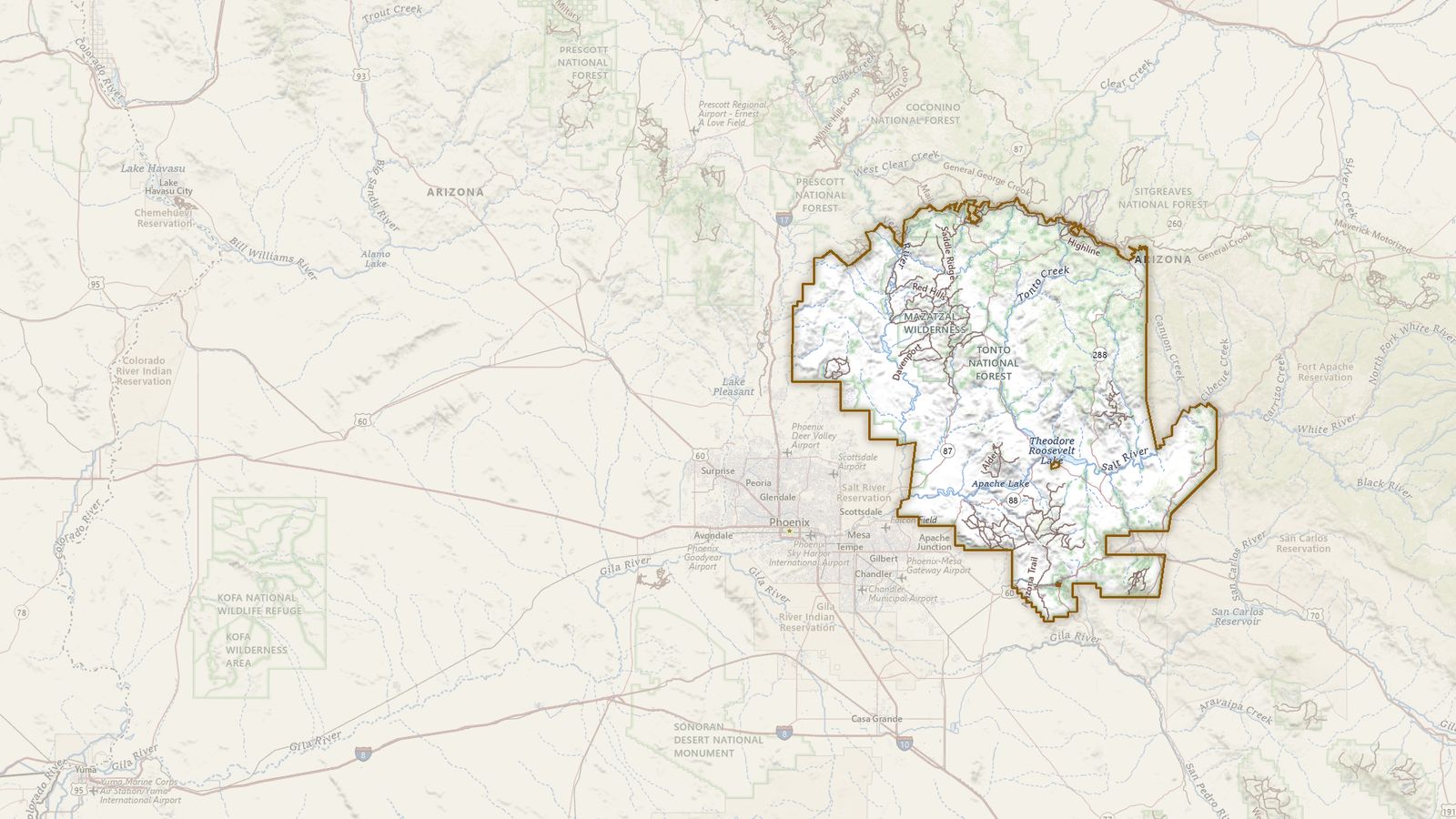
2,284 miles of motorized trail designated, not one of them mapped
Every one is in the agency’s route data with a length and a designation, and no location. Beaverhead-Deerlodge, 2,404 miles, the same. See the Tonto’s page
The plan is to make digital maps the legal record over a network that is 45 percent digitized
The notice proposes that "integrated digital maps" become "the authoritative public source for designations," and cites section 127 of the EXPLORE Act, which directs the agency to provide GIS-compatible motor vehicle use maps for every unit. The record behind the sequence above: 28,595 of 62,717 motorized trail records carry a recorded length and no location at all. They are named, their status is listed as existing, and many carry live designations such as open to ATVs.
This is the rare part of the fight where the interests line up. A trail with no mapped location isn’t a protected trail. It’s a trail you can’t prove you’re allowed to be on, that a future map can quietly omit, and that no one can point to in a comment. Riders lose from that gap and so does everyone else.
See how much of your forest is missing
The access argument, taken seriously
There is a real complaint buried in this, and it deserves to be stated properly rather than waved off. Travel management planning has been slow, expensive and litigious. The notice points out that applying the full set of procedures to every revision, including clerical map corrections, imposes burdens out of proportion to the decision. That’s true, and people who ride have spent twenty years watching minor route changes take years. A rule that distinguishes a typo from a new trail is a reasonable thing to want.
What doesn’t follow is that the criteria are the obstacle. The system described as an unnecessary barrier is 97 percent built, and it was built on the criteria now proposed for removal.
What hunters and anglers have at stake
One piece of this reads like new access, and it is aimed squarely at hunters: the notice proposes processes for driving off route to retrieve a downed big-game animal, gather firewood or reach a dispersed camp. It’s worth reading closely before anyone calls it a win, because the current rule already allows it. Under 36 CFR 212.51(b) a forest can include, in its designation, limited motor vehicle use within a set distance of designated routes and within set time periods, solely for dispersed camping or for retrieving a big-game animal somebody legally took. What the proposal changes isn’t whether retrieval is possible. It’s the instrument: each use would run through a route or area designation, a written authorization or a categorical exemption, with geographic, seasonal, vehicle-class and resource-protection conditions attached. That’s a rewrite of a provision hunters already have, and it lives or dies on conditions the notice hasn’t written yet. Comments that say what those conditions need to look like on a named forest are the ones with somewhere to land.
The cost sits in the second of the four tests. 36 CFR 212.55(b)(2) is the line that makes a forest weigh “harassment of wildlife and significant disruption of wildlife habitats” before it puts a route on the map, and in practice that is where elk security cover through the season gets considered, where road density across a herd unit gets counted, and where sediment coming off a crossing into a trout stream has to be answered for. Remove the criterion and none of those questions is required anywhere in the process. A forest may still ask them. Nothing makes it. The people with the most to lose are the ones who go out for the animals, and they are the same people the access argument is being made on behalf of.
Where the authority went: the legal history, for anyone who wants it
None of this begins with the Forest Service. On 29 May 2026 the President signed Executive Order 14408, which rescinded Executive Order 11644, signed by Richard Nixon in 1972, and Executive Order 11989, signed by Jimmy Carter in 1977. Those two orders are what required federal agencies to designate off-road vehicle use against criteria that minimized damage to resources and conflict between users. EO 14408 called those criteria "vague, subjective" and "not required by statute," and directed every affected agency to rescind or revise the regulations built on them.
The minimization criteria in the travel management rule are those criteria. So is the parallel language in the Bureau of Land Management’s off-road vehicle regulations at 43 CFR 8342.1, which is also now in line for revision.
The Forest Service moved first. As of 17 September 2026 the Interior Department hasn’t published a BLM proposal, so there’s no BLM docket, no deadline and nothing anyone can comment on yet. That’s why this map is Forest Service ground: it covers the rule that’s actually on the table. We watch the Federal Register for the BLM half daily, and when it lands it gets its own chapter here.
One artifact of that is still sitting in the Code of Federal Regulations. Subpart C of part 212, the over-snow vehicle rule, lists its legal authority as:
The regulation cites, as the source of its authority, two executive orders that no longer exist.
Subpart C is worth pausing on for a second reason. It exists because a court ordered it. In Winter Wildlands Alliance v. U.S. Forest Service, decided in the District of Idaho in 2013, the court held that the 2005 rule’s decision to exempt snowmobiles from travel management violated Executive Order 11644, and ordered the agency to write a compliant rule. That order produced Subpart C in 2015. Rescind 11644 and the holding that forced it into existence has nothing underneath it. Eleven years on, that rule has been implemented on 25 of the roughly 101 units that get enough snow to need it. The agency’s own notice says so.
The rule itself is 36 CFR part 212, adopted November 2005, enforced through 36 CFR 261.13, which prohibits motor vehicle use off the designated system. Subpart B holds the designation process and the four criteria at 212.55(b); under 212.56 the result is published on the MVUM, and under 212.57 the forest is supposed to monitor what the designation does. Subpart A includes 212.5(b)(1), the minimum road system requirement the notice would replace.
Three minutes, and it goes on the federal record
134,377 comments are on the official record.
The Forest Service took public comment through docket FS-2026-0100 on regulations.gov until 23 September 2026.
Specific comments carry weight and identical ones don’t. A comment that names a forest, says what you do there, and objects to a particular part of the proposal is one the agency has to answer on the record. The agency says it will study alternatives on four questions in particular, and these are where a comment lands hardest:
- Whether "open unless closed" applies only to routes designated from here on, or reopens routes already closed.
- Whether an "existing" route means one in the official transportation atlas, or anything visible from the air.
- Which public-involvement and monitoring requirements survive.
- Whether class 1 e-bikes stop counting as motor vehicles.
We’ll write it with you. Pick your forest, say in your own words what you do there and what you’ve seen, and your letter comes back carrying that forest’s own figures. You edit it, you file it. Nothing you type reaches us.
Write your comment Talking points and a starter comment Comment on regulations.gov Look up your forest first
When the rule itself lands, we will tell you
This is a notice of intent. The proposed rule comes later, with its own comment window. One email when it does, and when a window opens on the public lands you use. Nothing else.